Fail:Iditarod_Trail_BLM_map.jpg
From Wikipedia, the free encyclopedia
Tiada leraian lebih besar.
Iditarod_Trail_BLM_map.jpg (759 × 576 piksel, saiz fail: 85 KB, jenis MIME: image/jpeg)
Fail ini dari Wikimedia Commons dan mungkin digunakan oleh projek lain. Penerangan pada laman penerangan failnya di sana ditunjukkan di bawah.
Ringkasan
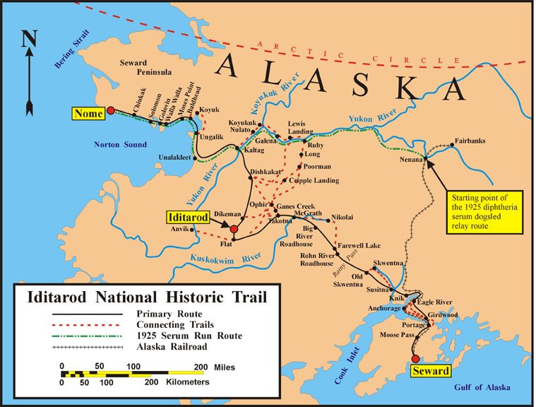
| KeteranganIditarod Trail BLM map.jpg | Map of the historical Iditarod Trail and the current Iditarod National Historic Trail in Alaska, USA |
| Tarikh | |
| Sumber | U.S. Bureau of Land Management |
| Pengarang | U.S. Bureau of Land Management |
| Kebenaran (Penggunaan semula fail ini) |
public domain, as a U.S. federal government work |

|
This map image could be re-created using vector graphics as an SVG file. This has several advantages; see Commons:Media for cleanup for more information. If an SVG form of this image is available, please upload it and afterwards replace this template with
{{vector version available|new image name}}.
It is recommended to name the SVG file “Iditarod Trail BLM map.svg”—then the template Vector version available (or Vva) does not need the new image name parameter. |
 | This map image was uploaded in the JPEG format even though it consists of non-photographic data. This information could be stored more efficiently or accurately in the PNG or SVG format. If possible, please upload a PNG or SVG version of this image without compression artifacts, derived from a non-JPEG source (or with existing artifacts removed). After doing so, please tag the JPEG version with {{Superseded|NewImage.ext}} and remove this tag. This tag should not be applied to photographs or scans. If this image is a diagram or other image suitable for vectorisation, please tag this image with {{Convert to SVG}} instead of {{BadJPEG}}. If not suitable for vectorisation, use {{Convert to PNG}}. For more information, see {{BadJPEG}}. |  |
Perlesenan
| Public domainPublic domainfalsefalse |
| This image is a work of a Bureau of Land Management* employee, taken or made as part of that person's official duties. As a work of the U.S. federal government, the image is in the public domain in the United States. *or predecessor organization |
Captions
Add a one-line explanation of what this file represents
Items portrayed in this file
menggambarkan
2007
media type Inggeris
image/jpeg
Sejarah fail
Klik pada tarikh/waktu untuk melihat rupa fail tersebut pada waktu itu.
| Tarikh/Waktu | Gambar kenit | Ukuran | Pengguna | Komen | |
|---|---|---|---|---|---|
| semasa | 05:47, 9 Februari 2008 | | 759 × 576 (85 KB) | Delirium | {{Information |Description=Map of the historical Iditarod Trail and the current Iditarod National Historic Trail in Alaska, USA |Source=[http://www.blm.gov/ak/st/en/prog/sa/iditarod/inht_map.html U.S. Bureau of Land Management] |Date=2007 |Author=U.S. Bur |
Penggunaan fail
Laman berikut menggunakan fail ini:
Penggunaan fail sejagat
Fail ini digunakan oleh wiki-wiki lain yang berikut:
- Penggunaan di az.wikipedia.org
- Penggunaan di cs.wikipedia.org
- Penggunaan di de.wikipedia.org
- Penggunaan di en.wikipedia.org
- Penggunaan di en.wikivoyage.org
- Penggunaan di es.wikipedia.org
- Penggunaan di fr.wikipedia.org
- Iditarod Trail
- Course au sérum de 1925
- Discussion:Course au sérum de 1925
- Wikipédia:Le saviez-vous ?/Archives/2015
- Utilisateur:GhosterBot/BacASable/testStat/Visibilité des anecdotes (2015)
- Utilisateur:GhosterBot/BacASable/testStat/Visibilité des anecdotes (2015)/2015 02
- Wikipédia:Statistiques des anecdotes de la page d'accueil/Visibilité des anecdotes (2015)/2015 02
- Wikipédia:Statistiques des anecdotes de la page d'accueil/Visibilité des anecdotes (2015)
- Discussion:Course au sérum de 1925/LSV 16741
- Penggunaan di he.wikipedia.org
- Penggunaan di id.wikipedia.org
- Penggunaan di it.wikipedia.org
- Penggunaan di nl.wikipedia.org
- Penggunaan di pl.wikipedia.org
- Penggunaan di ru.wikipedia.org
- Penggunaan di simple.wikipedia.org
- Penggunaan di uk.wikipedia.org
- Penggunaan di uz.wikipedia.org
- Penggunaan di vi.wikipedia.org
- Penggunaan di www.wikidata.org
- Penggunaan di zh.wikipedia.org
Metadata
Fail ini mengandungi maklumat tambahan daripada kamera digital atau pengimbas yang digunakan untuk menghasilkannya. Jika fail ini telah diubah suai daripada rupa asalnya, beberapa butiran dalam maklumat ini mungkin sudah tidak relevan.
| _error | 0 |
|---|
Diambil daripada "https://ms.wikipedia.org/wiki/Fail:Iditarod_Trail_BLM_map.jpg"