Bestand:Bass_Islands_map.png
Uit Wikipedia, de vrije encyclopedia
Grootte van deze voorvertoning: 484 × 599 pixels. Andere resoluties: 194 × 240 pixels | 388 × 480 pixels.
Oorspronkelijk bestand (800 × 990 pixels, bestandsgrootte: 261 kB, MIME-type: image/png)
| Dit is een bestand van Wikimedia Commons. Onderstaande beschrijving komt van de beschrijving van het bestand daar. |
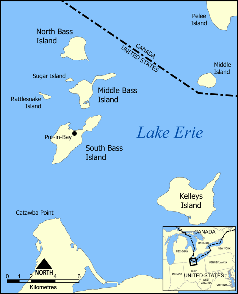
This is a map of the Bass Islands in Lake Erie. The three main islands are South Bass Island, Middle Bass Island, and North Bass Island. As well, the map shows the nearby Kelleys Island, Sugar Island, Rattlesnake Island, and Middle Island.
Created by NormanEinstein, June 23, 2005.
Ik, de auteursrechthebbende van dit werk, maak het hierbij onder de volgende licentie beschikbaar:

|
Toestemming wordt verleend voor het kopiëren, verspreiden en/of wijzigen van dit document onder de voorwaarden van de GNU-licentie voor vrije documentatie, versie 1.2 of enige latere versie als gepubliceerd door de Free Software Foundation; zonder Invariant Sections, zonder Front-Cover Texts, en zonder Back-Cover Texts. Een kopie van de licentie is opgenomen in de sectie GNU-licentie voor vrije documentatie.http://www.gnu.org/copyleft/fdl.htmlGFDLGNU Free Documentation Licensetruetrue |
| Dit bestand is gelicenseerd onder de Creative Commons-licentie Naamsvermelding-Gelijk delen 3.0 Unported | ||
| ||
| Deze licentietag is toegevoegd aan dit bestand in verband met de GFDL licentie-update.http://creativecommons.org/licenses/by-sa/3.0/CC BY-SA 3.0Creative Commons Attribution-Share Alike 3.0truetrue |
Bijschriften
Beschrijf in één regel wat dit bestand voorstelt
Items getoond in dit bestand
beeldt af
image/png
e9641d032fcfb0003520dfb7c242f3c60a302ca0
266.975 byte
990 pixel
800 pixel
Bestandsgeschiedenis
Klik op een datum/tijd om het bestand te zien zoals het destijds was.
| Datum/tijd | Miniatuur | Afmetingen | Gebruiker | Opmerking | |
|---|---|---|---|---|---|
| huidige versie | 23 jun 2005 18:32 | | 800 × 990 (261 kB) | NormanEinstein | Corrected boundary line problem. |
| 23 jun 2005 17:04 |  | 800 × 990 (262 kB) | NormanEinstein | This is a map of the Bass Islands in Lake Erie. The three main islands are South Bass Island, Middle Bass Island, and North Bass Island. As well, the map shows the nearby Kelleys Island, Sugar Island, Rattlesnake Island, and Middle Island. Created by Nor |
Bestandsgebruik
Dit bestand wordt op de volgende pagina gebruikt:
Globaal bestandsgebruik
De volgende andere wiki's gebruiken dit bestand:
- Gebruikt op ceb.wikipedia.org
- Gebruikt op de.wikipedia.org
- Gebruikt op en.wikipedia.org
- Gebruikt op es.wikipedia.org
- Gebruikt op fr.wikipedia.org
- Gebruikt op hu.wikipedia.org
- Gebruikt op pt.wikipedia.org
- Gebruikt op ro.wikipedia.org
- Gebruikt op uk.wikipedia.org
- Gebruikt op ur.wikipedia.org
- Gebruikt op vi.wikipedia.org
- Gebruikt op www.wikidata.org
Overgenomen van "https://nl.wikipedia.org/wiki/Bestand:Bass_Islands_map.png"