Bestand:Ghana-Eastern.png
Uit Wikipedia, de vrije encyclopedia
Geen hogere resolutie beschikbaar.
Ghana-Eastern.png (150 × 211 pixels, bestandsgrootte: 4 kB, MIME-type: image/png)
| Dit is een bestand van Wikimedia Commons. Onderstaande beschrijving komt van de beschrijving van het bestand daar. |
| BeschrijvingGhana-Eastern.png |
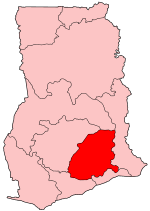
Map of Ghana showing Eastern region. |
||
| Datum | |||
| Bron | Self-made, traced from public domain UN or CIA maps. | ||
| Maker | |||
| Toestemming (Hergebruik van dit bestand) |
Provide attribution, please. See below. | ||
| Georeferencing | Georeference the map in Wikimaps Warper If inappropriate please set warp_status = skip to hide. | ||
| Andere versies |
See Image:Ghana regions named.png for the numbered map of the regions.
|

Ik, de auteursrechthebbende van dit werk, maak het hierbij onder de volgende licenties beschikbaar:
Dit bestand is gelicenseerd onder de Creative Commons-licenties Naamsvermelding-Gelijk delen 2.5 Algemeen, 2.0 Algemeen en 1.0 Algemeen.
- De gebruiker mag:
- Delen – het werk kopiëren, verspreiden en doorgeven
- Remixen – afgeleide werken maken
- Onder de volgende voorwaarden:
- naamsvermelding – U moet op een gepaste manier aan naamsvermelding doen, een link naar de licentie geven, en aangeven of er wijzigingen in het werk zijn aangebracht. U mag dit op elke redelijke manier doen, maar niet zodanig dat de indruk wordt gewekt dat de licentiegever instemt met uw werk of uw gebruik van zijn werk.
- Gelijk delen – Als u het werk heeft geremixt, veranderd, of erop heeft voortgebouwd, moet u het gewijzigde materiaal verspreiden onder dezelfde licentie als het oorspronkelijke werk, of een daarmee compatibele licentie.

|
Toestemming wordt verleend voor het kopiëren, verspreiden en/of wijzigen van dit document onder de voorwaarden van de GNU-licentie voor vrije documentatie, versie 1.2 of enige latere versie als gepubliceerd door de Free Software Foundation; zonder Invariant Sections, zonder Front-Cover Texts, en zonder Back-Cover Texts. Een kopie van de licentie is opgenomen in de sectie GNU-licentie voor vrije documentatie.http://www.gnu.org/copyleft/fdl.htmlGFDLGNU Free Documentation Licensetruetrue |
| Dit bestand is gelicenseerd onder de Creative Commons-licentie Naamsvermelding-Gelijk delen 3.0 Unported | ||
| ||
| Deze licentietag is toegevoegd aan dit bestand in verband met de GFDL licentie-update.http://creativecommons.org/licenses/by-sa/3.0/CC BY-SA 3.0Creative Commons Attribution-Share Alike 3.0truetrue |
U mag zelf één van de licenties kiezen.
Bijschriften
Beschrijf in één regel wat dit bestand voorstelt
Items getoond in dit bestand
beeldt af
juni 2005
image/png
Bestandsgeschiedenis
Klik op een datum/tijd om het bestand te zien zoals het destijds was.
| Datum/tijd | Miniatuur | Afmetingen | Gebruiker | Opmerking | |
|---|---|---|---|---|---|
| huidige versie | 27 jun 2005 11:19 | | 150 × 211 (4 kB) | Golbez | Map of Ghana showing Eastern region. Source: Made by User:Golbez. {{cc-by-sa-2.0}} Category:Maps of Ghana\ |
Bestandsgebruik
Dit bestand wordt op de volgende pagina gebruikt:
Globaal bestandsgebruik
De volgende andere wiki's gebruiken dit bestand:
- Gebruikt op de.wikipedia.org
- Gebruikt op dga.wikipedia.org
- Gebruikt op en.wikipedia.org
- Akwatia (Ghana parliament constituency)
- Akim Swedru (Ghana parliament constituency)
- Atiwa (Ghana parliament constituency)
- Upper Manya (Ghana parliament constituency)
- Akropong (Ghana parliament constituency)
- Okere (Ghana parliament constituency)
- Aburi-Nsawam (Ghana parliament constituency)
- Ofoase-Ayirebi (Ghana parliament constituency)
- Asuogyaman (Ghana parliament constituency)
- Akim Oda (Ghana parliament constituency)
- Abirem (Ghana parliament constituency)
- Akim Abuakwa North (Ghana parliament constituency)
- Akim Abuakwa South (Ghana parliament constituency)
- Fanteakwa (Ghana parliament constituency)
- Kade (Ghana parliament constituency)
- Abetifi (Ghana parliament constituency)
- Afram Plains North (Ghana parliament constituency)
- Afram Plains South (Ghana parliament constituency)
- Mpraeso (Ghana parliament constituency)
- Nkawkaw (Ghana parliament constituency)
- Lower Manya (Ghana parliament constituency)
- New Juaben North (Ghana parliament constituency)
- New Juaben South
- Ayensuano (Ghana parliament constituency)
- Suhum (Ghana parliament constituency)
- Lower West Akim (Ghana parliament constituency)
- Upper West Akim
- Yilo Krobo (Ghana parliament constituency)
- Akwapim South (Ghana parliament constituency)
- Nsawam Adoagyiri (Ghana parliament constituency)
- Fanteakwa North (Ghana parliament constituency)
- Fanteakwa South (Ghana parliament constituency)
- Akuapem North (Ghana parliament constituency)
- Asene Akroso-Manso (Ghana parliament constituency)
- User:GerardM/Constituency of the Parliament of the Republic of Ghana
- Gebruikt op gpe.wikipedia.org
- Abirem (Ghana parliament constituency)
- Akim Abuakwa North (Ghana parliament constituency)
- Akim Abuakwa South (Ghana parliament constituency)
- Akim Swedru (Ghana parliament constituency)
- Akwapim South (Ghana parliament constituency)
- Akwatia (Ghana parliament constituency)
- Asene Akroso-Manso (Ghana parliament constituency)
- Asuogyaman (Ghana parliament constituency)
- Ayensuano (Ghana parliament constituency)
- Fanteakwa North (Ghana parliament constituency)
Globaal gebruik van dit bestand bekijken.
Overgenomen van "https://nl.wikipedia.org/wiki/Bestand:Ghana-Eastern.png"