Bestand:Karte_Ljubljana_si.png
Uit Wikipedia, de vrije encyclopedia
Geen hogere resolutie beschikbaar.
Karte_Ljubljana_si.png (300 × 201 pixels, bestandsgrootte: 44 kB, MIME-type: image/png)
| Dit is een bestand van Wikimedia Commons. Onderstaande beschrijving komt van de beschrijving van het bestand daar. |
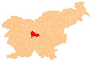
Deutsch: Karte der Gemeinde Ljubljana in Slowenien. Hergestellt vom Benutzer Plp der slowenischen Wikipedia.
English: Localization of Ljubljana in Slovenia. Creator Plp

|
Toestemming wordt verleend voor het kopiëren, verspreiden en/of wijzigen van dit document onder de voorwaarden van de GNU-licentie voor vrije documentatie, versie 1.2 of enige latere versie als gepubliceerd door de Free Software Foundation; zonder Invariant Sections, zonder Front-Cover Texts, en zonder Back-Cover Texts. Een kopie van de licentie is opgenomen in de sectie GNU-licentie voor vrije documentatie.http://www.gnu.org/copyleft/fdl.htmlGFDLGNU Free Documentation Licensetruetrue |
| Dit bestand is gelicenseerd onder de Creative Commons-licentie Naamsvermelding-Gelijk delen 3.0 Unported | ||
| ||
| Deze licentietag is toegevoegd aan dit bestand in verband met de GFDL licentie-update.http://creativecommons.org/licenses/by-sa/3.0/CC BY-SA 3.0Creative Commons Attribution-Share Alike 3.0truetrue |
Bijschriften
Beschrijf in één regel wat dit bestand voorstelt
Items getoond in dit bestand
beeldt af
image/png
Bestandsgeschiedenis
Klik op een datum/tijd om het bestand te zien zoals het destijds was.
| Datum/tijd | Miniatuur | Afmetingen | Gebruiker | Opmerking | |
|---|---|---|---|---|---|
| huidige versie | 19 jul 2005 04:21 | | 300 × 201 (44 kB) | Besednjak~commonswiki | Karte der Gemeinde Ljubljana in Slowenien. Hergestellt von Benutzer Plp der sl.wikipedia. {{GFDL}} |
Bestandsgebruik
Dit bestand wordt op de volgende pagina gebruikt:
Globaal bestandsgebruik
De volgende andere wiki's gebruiken dit bestand:
- Gebruikt op af.wikipedia.org
- Gebruikt op an.wikipedia.org
- Gebruikt op ar.wikipedia.org
- Gebruikt op arz.wikipedia.org
- Gebruikt op ast.wikipedia.org
- Gebruikt op bar.wikipedia.org
- Gebruikt op bg.wikipedia.org
- Шаблон:Община Любляна
- Бесница
- Брезе при Липоглаву
- Велики Липоглав
- Велико Требелево
- Внайнаре
- Волавле
- Габре при Янчах
- Двор (община Любляна)
- Долго Бърдо (община Любляна)
- Заградишче
- Згорня Бесница (община Любляна)
- Згорне Гамелне
- Липе (селище)
- Мали Връх при Прежганю
- Мали Липоглав
- Мало Требелево
- Медно
- Панце
- Подград (община Любляна)
- Подлипоглав
- Прежгане
- Равно Бърдо
- Рашица (община Любляна)
- Репче (община Любляна)
- Садиня вас (община Любляна)
- Село при Панцах
- Сподне Гамелне
- Средне Гамелне
- Станежице
- Тошко Чело
- Туи Гръм
- Чешница (община Любляна)
- Черна вас
- Шентпавел
- Явор (община Любляна)
- Янче (Словения)
- Gebruikt op ca.wikipedia.org
- Gebruikt op ceb.wikipedia.org
- Gebruikt op cs.wikipedia.org
- Gebruikt op cu.wikipedia.org
- Gebruikt op de.wikipedia.org
Globaal gebruik van dit bestand bekijken.
Overgenomen van "https://nl.wikipedia.org/wiki/Bestand:Karte_Ljubljana_si.png"