Bestand:KatrinaNewOrleansFlooded_edit2.jpg
Uit Wikipedia, de vrije encyclopedia
Oorspronkelijk bestand (1.153 × 1.514 pixels, bestandsgrootte: 1,23 MB, MIME-type: image/jpeg)
| Dit is een bestand van Wikimedia Commons. Onderstaande beschrijving komt van de beschrijving van het bestand daar. |
Beschrijving
| BeschrijvingKatrinaNewOrleansFlooded edit2.jpg |
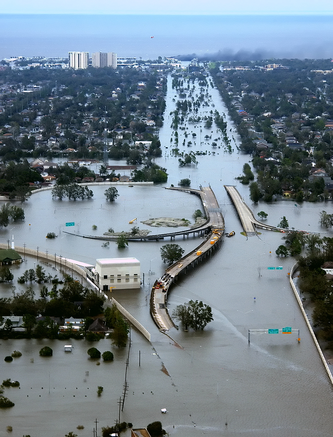
English: New Orleans, Louisiana in the aftermath of Hurricane Katrina (2005:08:29 17:24:22), showing Interstate 10 at West End Boulevard, looking towards Lake Pontchartrain.
The 17th Street Canal is just beyond the left edge of the image. The breach in the levee of that canal was responsible for much of the flooding of the city in the hours after the hurricane. In the foreground, the intersection is the juncture of I-10, running from the bottom of the photo and curving out of the photo to the left, with the western end of I-610, which extends off the photo from the center right, and the West End entrance/exit from I-10. The block shaped building at center left front is a pumping station, one of those used to pump water from heavy rains off city streets in more normal times. The far eastern end of Veterans Memorial Boulevard is seen just back from the interchange extending to the left. The view looks north toward Lake Pontchartrain. The stretch of ground with no buildings from the Interchange to the lake is Pontchartrain Blvd. (on the left) and West End Blvd. (on the right), with a linear park (formerly the route of the New Basin Canal) between them. Smoke can be seen rising near the lake, probably from the burning of the Southern Yacht Club building. This photo provided by the U.S. Coast Guard shows flooded roadways as the Coast Guard conducted initial Hurricane Katrina damage assessment overflights of New Orleans, Monday Aug. 29, 2005. Edit, selective noise reduction by MfieldDeutsch: Das überflutete New Orleans
Español: Carretera Interestatal 10 en Nueva Orleans inundada después del paso del huracán Katrina a finales de agosto de 2005. La inundación se provocó por una brecha en el dique de contención durante el paso del huracán.
Suomi: 80% New Orleansista jäi veden alle, kun hurrikaani Katrina iski Yhdysvaltain rannikolle elokuussa 2005
Türkçe: Sel altında kalan I-10/I-610/West End Bulvarlarının kesiştiği kavşak, kuzeybatı New Orleans ve Metairie, Louisiana. |
||||
| Datum | |||||
| Bron | Published here, here, and here | ||||
| Auteur | AP Photo/U.S. Coast Guard, Petty Officer 2nd Class Kyle Niemi | ||||
| Toestemming (Hergebruik van dit bestand) |
|
||||
| Andere versies |
|

Onderscheidingen
|
Bijschriften
Items getoond in dit bestand
beeldt af
29 aug 2005
image/jpeg
Bestandsgeschiedenis
Klik op een datum/tijd om het bestand te zien zoals het destijds was.
| Datum/tijd | Miniatuur | Afmetingen | Gebruiker | Opmerking | |
|---|---|---|---|---|---|
| huidige versie | 18 apr 2008 05:26 | | 1.153 × 1.514 (1,23 MB) | Mfield | == Summary == {{Information |Description=New Orleans, Louisiana in the aftermath of Hurricane Katrina (2005:08:29 17:24:22), showing Interstate 10 at West End Boulevard, looking towards Lake Pontchartrain. The 17th Street Canal is just beyond the left e |
Bestandsgebruik
Dit bestand wordt op de volgende pagina gebruikt:
Globaal bestandsgebruik
De volgende andere wiki's gebruiken dit bestand:
- Gebruikt op ar.wikipedia.org
- Gebruikt op ast.wikipedia.org
- Gebruikt op az.wiktionary.org
- Gebruikt op ba.wikipedia.org
- Gebruikt op be.wikipedia.org
- Gebruikt op bg.wikipedia.org
- Gebruikt op bs.wikipedia.org
- Gebruikt op bxr.wikipedia.org
- Gebruikt op ca.wikipedia.org
- Gebruikt op cv.wikipedia.org
- Gebruikt op cy.wikipedia.org
- Gebruikt op dag.wikipedia.org
- Gebruikt op de.wiktionary.org
- Gebruikt op el.wikipedia.org
- Gebruikt op en.wikipedia.org
- 2000s
- Wikipedia:Selected anniversaries/August 29
- 2005 Atlantic hurricane season
- User:E. Brown
- Habitat destruction
- User talk:Spikebrennan
- User:Spikebrennan
- Hurricane Katrina
- Effects of Hurricane Katrina in New Orleans
- User:UniReb
- Pontchartrain Expressway
- Wikipedia:WikiProject Tropical cyclones
- User:Nemalki
- User:Canuck85
- User:Lionheart Omega
- User:UBX/remember Katrina
- User:Robomaeyhem
- User talk:Hurricanehink/Archive 2
- User:VerruckteDan
- User:Omni ND/Userboxes
- User:Lavishluau
- User:Eastlaw/UBX
- User:Krzysiu Jarzyna
- User:Samwisep86
Globaal gebruik van dit bestand bekijken.
Metadata
Dit bestand bevat metadata met EXIF-informatie, die door een fotocamera, scanner of fotobewerkingsprogramma toegevoegd kan zijn.
| Gebruikte software | Adobe Photoshop CS3 Macintosh |
|---|---|
| Oriëntatie | Normaal |
| Horizontale resolutie | 72 dpi |
| Verticale resolutie | 72 dpi |
| Tijdstip laatste bestandswijziging | 17 apr 2008 20:24 |
| Kleurruimte | sRGB |