Bestand:Kayangel.png
Uit Wikipedia, de vrije encyclopedia
Grootte van deze voorvertoning: 384 × 599 pixels. Andere resoluties: 154 × 240 pixels | 466 × 727 pixels.
Oorspronkelijk bestand (466 × 727 pixels, bestandsgrootte: 141 kB, MIME-type: image/png)
| Dit is een bestand van Wikimedia Commons. Onderstaande beschrijving komt van de beschrijving van het bestand daar. |
Beschrijving
| BeschrijvingKayangel.png |
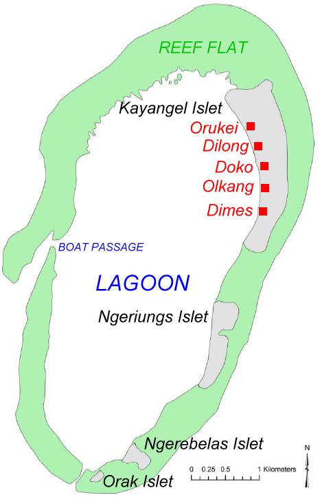
English: Map of Kayangel Atoll, Palau. Based on map from NOAA |
| Datum | |
| Bron | original source: http://ccmaserver.nos.noaa.gov/products/biogeography/Palau_IKONOS_GCPs_report.pdf (PDF) |
| Auteur | NOAA, modified by Ratzer to show names of islets and villages |
Licentie
| Public domainPublic domainfalsefalse |
Deze afbeelding is in het publiek domein omdat het materiaal bevat dat oorspronkelijk van de National Oceanic and Atmospheric Administration kwam in de Verenigde Staten en genomen of gemaakt is tijdens de officiële werkzaamheden van een werknemer.
العربية ∙ čeština ∙ Deutsch ∙ Zazaki ∙ English ∙ español ∙ eesti ∙ suomi ∙ français ∙ hrvatski ∙ magyar ∙ italiano ∙ 日本語 ∙ 한국어 ∙ македонски ∙ മലയാളം ∙ Plattdüütsch ∙ Nederlands ∙ polski ∙ português ∙ română ∙ русский ∙ sicilianu ∙ slovenščina ∙ Türkçe ∙ Tiếng Việt ∙ 简体中文 ∙ 繁體中文 ∙ +/− |
Oorspronkelijk uploadlogboek
| date/time | username | Dimensions | File Size | edit summary |
|---|---|---|---|---|
| 06:12, 08 July 2006 | Ratzer | 466×727 | 141 KB | (new version (workover by me) |
| 15:30, 07 July 2006 | Ratzer | 466×727 | 139 KB | (version 2 - slightly worked over) |
| 10:53, 07 July 2006 | Ratzer | 466×727 | 132 KB | (Base map from http://ccmaserver.nos.noaa.gov/products/biogeography/Palau_IKONOS_GCPs_report.pdf (NOAA page -> U.S. government work) modified by me to show names of islets and villages) |
Bijschriften
Beschrijf in één regel wat dit bestand voorstelt
Items getoond in dit bestand
beeldt af
Bestandsgeschiedenis
Klik op een datum/tijd om het bestand te zien zoals het destijds was.
| Datum/tijd | Miniatuur | Afmetingen | Gebruiker | Opmerking | |
|---|---|---|---|---|---|
| huidige versie | 7 mei 2009 10:03 | | 466 × 727 (141 kB) | Telim tor | == {{int:filedesc}} == {{Information |Description=Map of Kayangel Atoll, Palau. Based on map from NOAA |Source=original source: http://ccmaserver.nos.noaa.gov/products/biogeography/Palau_IKONOS_GCPs_report.pdf (PDF) |Date={{Date|2006}} |Author=NOAA, modif |
Bestandsgebruik
Dit bestand wordt op de volgende 6 pagina's gebruikt:
Globaal bestandsgebruik
De volgende andere wiki's gebruiken dit bestand:
- Gebruikt op ar.wikipedia.org
- Gebruikt op en.wikipedia.org
- Gebruikt op es.wikipedia.org
- Gebruikt op ja.wikipedia.org
- Gebruikt op ko.wikipedia.org
- Gebruikt op lt.wikipedia.org
- Gebruikt op mk.wikipedia.org
- Gebruikt op mrj.wikipedia.org
- Gebruikt op pt.wikipedia.org
- Gebruikt op ru.wikipedia.org
- Gebruikt op rw.wikipedia.org
- Gebruikt op uk.wikipedia.org
- Gebruikt op vi.wikipedia.org
Overgenomen van "https://nl.wikipedia.org/wiki/Bestand:Kayangel.png"