Bestand:Lake_Tiberias_(Sea_of_Galilee),_Northern_Israel.jpg
Uit Wikipedia, de vrije encyclopedia
Grootte van deze voorvertoning: 398 × 599 pixels. Andere resoluties: 159 × 240 pixels | 319 × 480 pixels | 510 × 768 pixels | 680 × 1.024 pixels | 1.440 × 2.168 pixels.
Oorspronkelijk bestand (1.440 × 2.168 pixels, bestandsgrootte: 1,15 MB, MIME-type: image/jpeg)
| Dit is een bestand van Wikimedia Commons. Onderstaande beschrijving komt van de beschrijving van het bestand daar. |
Beschrijving
| BeschrijvingLake Tiberias (Sea of Galilee), Northern Israel.jpg |
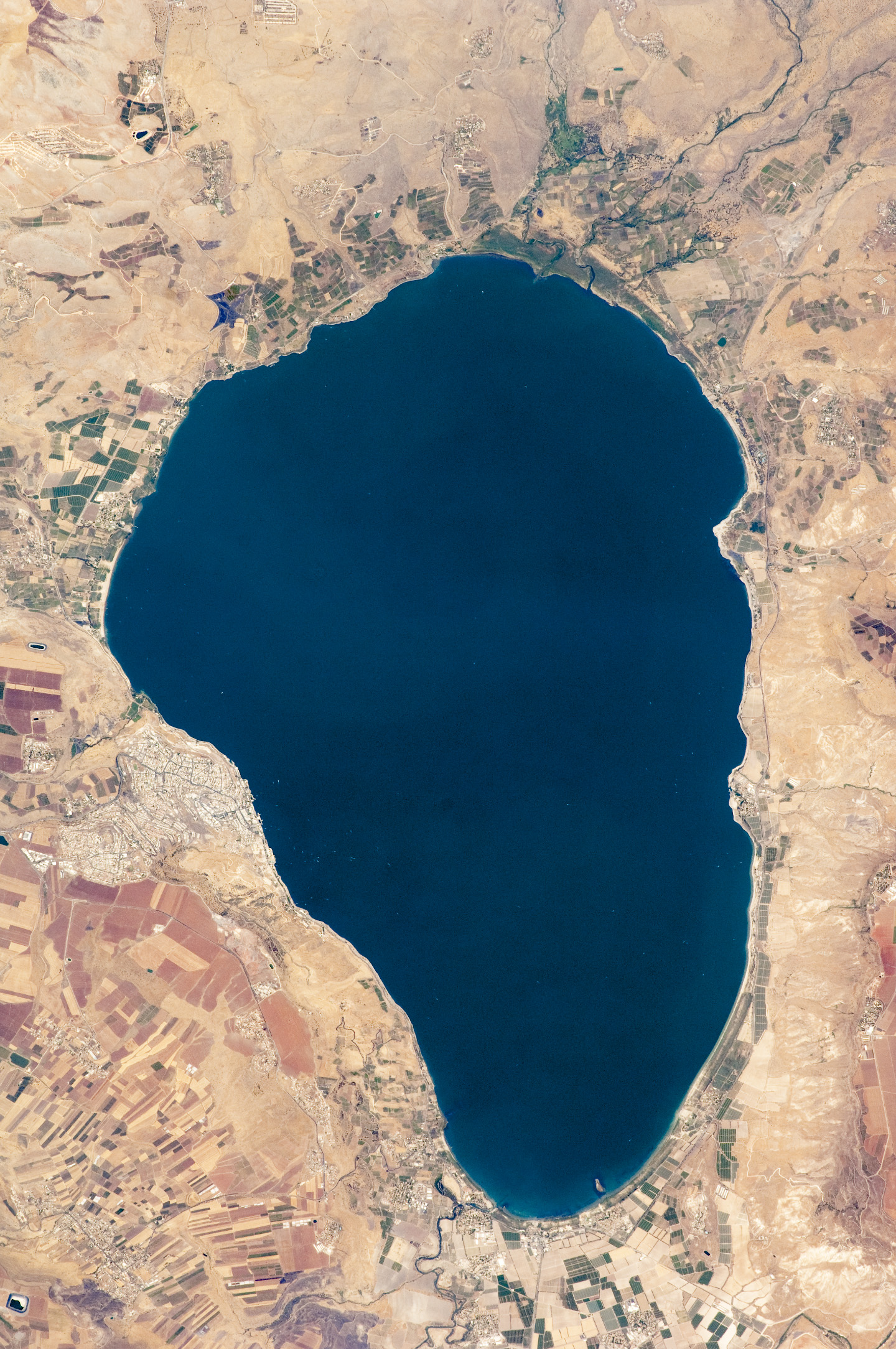
English: Israel’s largest freshwater lake, Lake Tiberias, is also known as the Sea of Tiberias, Lake of Gennesaret, Lake Kinneret, and the Sea of Galilee. The lake measures just more than 21 kilometres north-south, and it is only 43 meters deep. The lake is fed partly by underground springs related to the Jordan sector of the Great Rift Valley, but most of its water comes from the Jordan River, which enters from the north. The river’s winding course can be seen draining the south end of the lake at image bottom. Angular green and brown field patterns clothe most hillsides in this arid landscape. Bright roof tops are the hallmark of several villages in the area. The largest grouping of bright roofs and city blocks indicates the location of Tiberias (named for the Roman Emperor Tiberius), visible at image left on the south-western shore of the lake.
|
||||||||||||||||||||||||||||||||||||||||||||||||||
| Datum | |||||||||||||||||||||||||||||||||||||||||||||||||||
| Bron | NASA Earth Observatory | ||||||||||||||||||||||||||||||||||||||||||||||||||
| Auteur | This image was taken by the NASA Expedition 20 crew. | ||||||||||||||||||||||||||||||||||||||||||||||||||
| Andere versies | Afgeleide werken van dit bestand: (Sea of Galilee Northern Israel-2.jpg | ||||||||||||||||||||||||||||||||||||||||||||||||||
Image acquired with a Nikon D2Xs digital camera fitted with an 400 mm lens, and is provided by the ISS Crew Earth Observations experiment and Image Science & Analysis Laboratory, Johnson Space Centre.
Licentie
| Public domainPublic domainfalsefalse |
| Dit bestand bevindt zich in het publiek domein, omdat het gemaakt is door de NASA. In de reproductierichtlijnen van de NASA staat dat "NASA-materiaal niet beschermd wordt door auteursrecht, tenzij anders vermeld". | ||
 |
Waarschuwingen:
|
Bijschriften
Beschrijf in één regel wat dit bestand voorstelt
Mar de Galilea
Items getoond in dit bestand
beeldt af
14 sep 2009
0.00285714285714285714 seconde
400 millimeter
200
image/jpeg
Bestandsgeschiedenis
Klik op een datum/tijd om het bestand te zien zoals het destijds was.
| Datum/tijd | Miniatuur | Afmetingen | Gebruiker | Opmerking | |
|---|---|---|---|---|---|
| huidige versie | 14 sep 2009 13:32 | | 1.440 × 2.168 (1,15 MB) | Originalwana | {{Information |Description={{en|1=Israel’s largest freshwater lake, Lake Tiberias, is also known as the Sea of Tiberias, Lake of Gennesaret, Lake Kinneret, and the Sea of Galilee. The lake measures just more than 21 kilometres north-south, and it is |
Bestandsgebruik
Dit bestand wordt op de volgende pagina gebruikt:
Globaal bestandsgebruik
De volgende andere wiki's gebruiken dit bestand:
- Gebruikt op af.wikipedia.org
- Gebruikt op ar.wikipedia.org
- Gebruikt op bar.wikipedia.org
- Gebruikt op bn.wikipedia.org
- Gebruikt op br.wikipedia.org
- Gebruikt op ceb.wikipedia.org
- Gebruikt op cy.wikipedia.org
- Gebruikt op de.wikipedia.org
- Gebruikt op el.wikipedia.org
- Gebruikt op en.wikipedia.org
- Gebruikt op en.wikivoyage.org
- Gebruikt op eo.wikipedia.org
- Gebruikt op es.wikipedia.org
- Gebruikt op eu.wikipedia.org
- Gebruikt op fy.wikipedia.org
- Gebruikt op ga.wikipedia.org
- Gebruikt op he.wikipedia.org
- ויקיפדיה:תמונה מומלצת/המלצות קודמות/יולי 2012
- ויקיפדיה:תמונה מומלצת/הוספה למומלצים/ארכיון 40
- תבנית:תמונה מומלצת 23 ביולי 2012
- ויקיפדיה:ערכים מומלצים/המלצות קודמות/יולי 2013
- פורטל:ערכים מומלצים/ערכים/הכנרת
- תבנית:ערך מומלץ 1 ביולי 2013
- תבנית:ערך מומלץ 2 ביולי 2013
- ויקיפדיה:ערכים מומלצים/המלצות קודמות/פברואר 2018
- תבנית:ערך מומלץ 11 בפברואר 2018
- תבנית:ערך מומלץ 12 בפברואר 2018
- Gebruikt op he.wikivoyage.org
- Gebruikt op hy.wikipedia.org
- Gebruikt op ia.wikipedia.org
- Gebruikt op id.wikipedia.org
Globaal gebruik van dit bestand bekijken.
,_Northern_Israel.jpg)
Metadata
Dit bestand bevat metadata met EXIF-informatie, die door een fotocamera, scanner of fotobewerkingsprogramma toegevoegd kan zijn.
| Cameramodel | NIKON D2Xs |
|---|---|
| Gebruikte software | Adobe Photoshop CS4 Macintosh |
| Belichtingstijd | 1/350 sec (0,0028571428571429) |
| F-getal | f/9,5 |
| Tijdstip gegevensaanmaak | 15 aug 2009 10:21 |
| Sluitersnelheid in APEX | 8,451211 |
| Brandpuntsafstand | 400 mm |
| Merk camera | NIKON CORPORATION |
| Oriëntatie | Normaal |
| Horizontale resolutie | 72 dpi |
| Verticale resolutie | 72 dpi |
| Tijdstip laatste bestandswijziging | 10 sep 2009 10:55 |
| Belichtingsprogramma | Normaal programma |
| ISO-waarde | 200 |
| Exif-versie | 2.21 |
| Tijdstip digitalisering | 15 aug 2009 10:21 |
| Diafragma | 6,495855 |
| Belichtingscompensatie | 0 |
| Maximale diafragmawaarde van lens | 3 APEX (f/2,83) |
| Methode lichtmeting | Multi-segment (patroon) |
| Lichtbron | Onbekend |
| Flitser | Flits is niet afgegaan |
| Subseconden tijdstip bestandswijziging | 00 |
| Subseconden tijdstip datageneratie | 00 |
| Subseconden tijdstip digitalisatie | 00 |
| Kleurruimte | Ongekalibreerd |
| Meetmethode | Eén-chip-kleursensor |
| Aangepaste beeldverwerking | Normale verwerking |
| Belichtingsinstelling | Automatische belichting |
| Witbalans | Automatische witbalans |
| Digitale zoomfactor | 1 |
| Brandpuntsafstand (35mm-equivalent) | 600 mm |
| Soort opname | Standaard |
| Contrast | Zacht |
| Verzadiging | Normaal |
| Scherpte | Normaal |
| Afstandscategorie | Onbekend |
,_Northern_Israel.jpg)