Bestand:Map_Greece_expansion_1832-1947-nl.svg
Uit Wikipedia, de vrije encyclopedia

Afmetingen van deze voorvertoning van het type PNG van dit SVG-bestand: 457 × 599 pixels Andere resoluties: 183 × 240 pixels | 366 × 480 pixels | 586 × 768 pixels | 781 × 1.024 pixels | 1.562 × 2.048 pixels | 734 × 962 pixels.
Oorspronkelijk bestand (SVG-bestand, nominaal 734 × 962 pixels, bestandsgrootte: 56 kB)
| Dit is een bestand van Wikimedia Commons. Onderstaande beschrijving komt van de beschrijving van het bestand daar. |
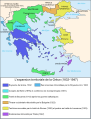
| BeschrijvingMap Greece expansion 1832-1947-nl.svg |
Čeština: Mapa zobrazuje územní expanzi Řeckého království (1832–1947). Dansk: Kort over Grækenlands territoriale udvidelser, 1832-1947. Deutsch: Territoriale Expansion Griechenlands 1832-1947. English: The territorial expansion of Greece, 1832-1947. Español: Mapa de la expansión territorial griega (1832-1947) Euskara: Greziaren lurralde hedapena 1832-1947 bitartean Français : L'expansion territoriale de la Grèce. 1832-1947. Hrvatski: Teritorijalno proširenje Grčke u razdoblju od 1832. do 1947. Italiano: L'espansione territoriale della Grecia dal 1832 al 1947 Magyar: Görögország területi növekedése (1832-1947) Occitan : Evolucions territòrialas de Grècia. Ελληνικά: Η εδαφική επέκταση της Ελλάδας 1832-1947. Македонски: Територијално проширување на Грција Українська: Територіальна експансія Греції (1832-1947). 日本語: ギリシャ王国の版図拡大 (1832-1947年) 中文: 希腊的领土变迁,1832年-1947年间。 العربية : خريطة تُصوِّر الأراضي التي استولت عليها اليونان مُنذُ سنة 1832م حين استقلالها عن الدولة العُثمانيَّة، وُصولًا إلى سنة 1947م |
||||||||
| Datum | |||||||||
| Bron | Image:Map Greece expansion 1832-1947-fr.svg (adaptation of Image:Population exchange 1923.gif, GFDL). Image renamed from Image:L'expansion territoriale de la Grèce 1832-1947.svg | ||||||||
| Auteur | Historicair, translator Rursus | ||||||||
| Toestemming (Hergebruik van dit bestand) |
|
||||||||
| Andere versies |
[bewerken]
|


.PNG)


.png)


Bijschriften
Beschrijf in één regel wat dit bestand voorstelt
Items getoond in dit bestand
beeldt af
31 mrt 2007
Bestandsgeschiedenis
Klik op een datum/tijd om het bestand te zien zoals het destijds was.
| Datum/tijd | Miniatuur | Afmetingen | Gebruiker | Opmerking | |
|---|---|---|---|---|---|
| huidige versie | 25 feb 2012 11:34 | | 734 × 962 (56 kB) | Brbbl | Added first Capital Nafplio, changed border colors to grey so that citynames are more readable, rearrenged legenda, added present names of certain cities and Island. |
| 24 feb 2012 20:11 |  | 734 × 962 (55 kB) | Brbbl | replaced Oost-Thracië in West-Thracië in legenda | |
| 15 feb 2008 13:36 |  | 734 × 962 (111 kB) | Evil berry | ||
| 15 feb 2008 13:34 |  | 734 × 962 (110 kB) | Evil berry | {{Information |Description= {{en|The territorial expansion of Greece, 1832-1947 (Dutch translation, added colors of WikiProject Maps).}} |Source=Image:Map Greece expansion 1832-1947-fr.svg (adaptation o |
Bestandsgebruik
Dit bestand wordt op de volgende 10 pagina's gebruikt:
Globaal bestandsgebruik
De volgende andere wiki's gebruiken dit bestand:
- Gebruikt op nl.wiktionary.org