Bestand:Naddniestrze.png
Uit Wikipedia, de vrije encyclopedia
Oorspronkelijk bestand (2.655 × 3.786 pixels, bestandsgrootte: 5,13 MB, MIME-type: image/png)
| Dit is een bestand van Wikimedia Commons. Onderstaande beschrijving komt van de beschrijving van het bestand daar. |
Beschrijving
| BeschrijvingNaddniestrze.png |
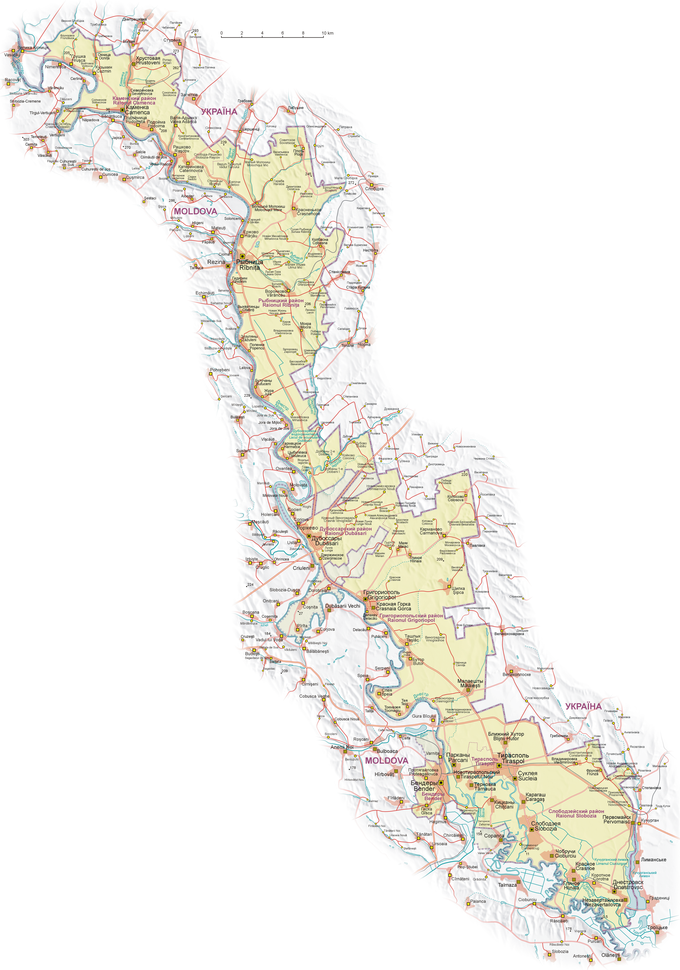
English: Map of Transnistria (with claimed area), based on Soviet and Ukrainian topographic map, and Shuttle Radar Topography Mission (STRM).
Geographical names:
 Polski: Mapa Naddniestrza (wraz z obszarem roszczeń). Mapa opracowana na podstawie radzieckich map topograficznych w skali 1:100 000 z końca lat 80. oraz ukraińskich map topograficznych z lat 2002-2006, rzeźba terenu wygenerowana na podstawie danych Shuttle Radar Topography Mission (STRM) udostępnionych przez United States Geological Survey.
Nazewnictwo geograficzne:
 Español: Mapa de Transnistria, basado en mapas topográficos soviéticos y ucranianos, y en la STRM. Nombres geográficos:
|
| Datum | |
| Bron | Eigen werk |
| Auteur | Aotearoa |
| Andere versies |
|


.png)


Licentie

|
Toestemming wordt verleend voor het kopiëren, verspreiden en/of wijzigen van dit document onder de voorwaarden van de GNU-licentie voor vrije documentatie, versie 1.2 of enige latere versie als gepubliceerd door de Free Software Foundation; zonder Invariant Sections, zonder Front-Cover Texts, en zonder Back-Cover Texts. Een kopie van de licentie is opgenomen in de sectie GNU-licentie voor vrije documentatie.http://www.gnu.org/copyleft/fdl.htmlGFDLGNU Free Documentation Licensetruetrue |
| Dit bestand is gelicenseerd onder de Creative Commons-licentie Naamsvermelding-Gelijk delen 3.0 Unported | ||
| ||
| Deze licentietag is toegevoegd aan dit bestand in verband met de GFDL licentie-update.http://creativecommons.org/licenses/by-sa/3.0/CC BY-SA 3.0Creative Commons Attribution-Share Alike 3.0truetrue |
|
Deze afbeelding is beoordeeld aan de hand van de richtlijnen voor Kwaliteitsafbeeldingen en wordt beschouwd als een Kwaliteitsafbeelding.
العربية ∙ جازايرية ∙ беларуская ∙ беларуская (тарашкевіца) ∙ български ∙ বাংলা ∙ català ∙ čeština ∙ Cymraeg ∙ Deutsch ∙ Schweizer Hochdeutsch ∙ Zazaki ∙ Ελληνικά ∙ English ∙ Esperanto ∙ español ∙ eesti ∙ euskara ∙ فارسی ∙ suomi ∙ français ∙ galego ∙ עברית ∙ हिन्दी ∙ hrvatski ∙ magyar ∙ հայերեն ∙ Bahasa Indonesia ∙ italiano ∙ 日本語 ∙ Jawa ∙ ქართული ∙ 한국어 ∙ kurdî ∙ Lëtzebuergesch ∙ lietuvių ∙ македонски ∙ മലയാളം ∙ मराठी ∙ Bahasa Melayu ∙ Nederlands ∙ Norfuk / Pitkern ∙ polski ∙ português ∙ português do Brasil ∙ rumantsch ∙ română ∙ русский ∙ sicilianu ∙ slovenčina ∙ slovenščina ∙ shqip ∙ српски / srpski ∙ svenska ∙ தமிழ் ∙ తెలుగు ∙ ไทย ∙ Tagalog ∙ Türkçe ∙ toki pona ∙ українська ∙ vèneto ∙ Tiếng Việt ∙ 中文 ∙ 中文(简体) ∙ 中文(繁體) ∙ +/− |
Bijschriften
Items getoond in dit bestand
beeldt af
Waarde zonder Wikidata-item
25 aug 2008
image/png
Bestandsgeschiedenis
Klik op een datum/tijd om het bestand te zien zoals het destijds was.
| Datum/tijd | Miniatuur | Afmetingen | Gebruiker | Opmerking | |
|---|---|---|---|---|---|
| huidige versie | 27 jul 2011 07:08 | | 2.655 × 3.786 (5,13 MB) | Nicolay Sidorov | + русское название села Коржево, исправил название села Zahorna - Загорное, а не "Захорна" |
| 14 sep 2008 12:18 |  | 2.655 × 3.786 (5,21 MB) | Aotearoa | {{Information |Description= |Source= |Date= |Author= |Permission= |other_versions= }} | |
| 25 aug 2008 22:01 |  | 2.655 × 3.790 (5,62 MB) | Aotearoa | {{Information |Description= |Source= |Date= |Author= |Permission= |other_versions= }} | |
| 25 aug 2008 21:39 |  | 2.962 × 4.230 (6,21 MB) | Aotearoa | {{Information |Description= |Source= |Date= |Author= |Permission= |other_versions= }} | |
| 25 aug 2008 21:27 |  | 3.054 × 4.271 (6,22 MB) | Aotearoa | {{Information |Description= |Source= |Date= |Author= |Permission= |other_versions= }} | |
| 25 aug 2008 20:51 |  | 3.054 × 4.271 (6,22 MB) | Aotearoa | {{Information |Description={{en|1=Map of Transnistria, based on Soviet and Ucrainian topographic map, and Shuttle Radar Topography Mission (STRM). Names in Transnistria according Transnistrian government}} {{pl|1= |
Bestandsgebruik
Dit bestand wordt op de volgende pagina gebruikt:
Globaal bestandsgebruik
De volgende andere wiki's gebruiken dit bestand:
- Gebruikt op ast.wikipedia.org
- Gebruikt op ca.wikipedia.org
- Gebruikt op cs.wikipedia.org
- Gebruikt op de.wikipedia.org
- Gebruikt op en.wikipedia.org
- Gebruikt op eo.wikipedia.org
- Gebruikt op eu.wikipedia.org
- Gebruikt op fr.wikipedia.org
- Gebruikt op fr.wikinews.org
- Gebruikt op gl.wikipedia.org
- Gebruikt op he.wikipedia.org
- Gebruikt op hu.wikipedia.org
- Gebruikt op is.wikipedia.org
- Gebruikt op ja.wikipedia.org
- Gebruikt op li.wikipedia.org
- Gebruikt op ml.wikipedia.org
- Gebruikt op pa.wikipedia.org
- Gebruikt op pl.wikipedia.org
- Wikipedysta:Aotearoa/brudnopis
- Wikipedia:Ilustracje na Medal/rysunki i animacje
- Wikipedia:Propozycje do Ilustracji na Medal/Naddniestrze.png
- Dyskusja pliku:Naddniestrze.png
- Wikipedysta:Aotearoa/mapy
- Szablon:Ilustracja na medal/2011-09-02
- Szablon:Ilustracja na medal/2012-02-14
- Szablon:Ilustracja na medal/2013-02-10
- Szablon:Ilustracja na medal/2014-08-16
- Wikipedysta:The Polish/Nieużywane szablony/Ilustracja na medal/1-500
- Wikipedysta:The Polish/Nieużywane szablony/Ilustracja na medal/501-1000
- Wikipedysta:The Polish/Nieużywane szablony/Ilustracja na medal/1001-1500
- Gebruikt op pt.wikipedia.org
- Gebruikt op ro.wikipedia.org
- Gebruikt op ru.wikipedia.org
- Gebruikt op sd.wikipedia.org
- Gebruikt op sr.wikipedia.org
Globaal gebruik van dit bestand bekijken.