Bestand:Ottoman_Provinces_Of_Present_day_Libyapng.png
Uit Wikipedia, de vrije encyclopedia
Geen hogere resolutie beschikbaar.
Ottoman_Provinces_Of_Present_day_Libya.png (282 × 314 pixels, bestandsgrootte: 22 kB, MIME-type: image/png)
| Dit is een bestand van Wikimedia Commons. Onderstaande beschrijving komt van de beschrijving van het bestand daar. |

|
Deze kaartafbeelding zou opnieuw moeten worden aangemaakt als een SVG-bestand door vectorafbeeldingen te gebruiken. Dit heeft een aantal voordelen; zie Commons:Media for cleanup voor meer informatie. Als er een SVG-formaat van deze afbeelding bestaat, dan deze graag uploaden. Nadat u dit heeft gedaan, gelieve dit sjabloon te vervangen door het sjabloon {{vector version available|nieuwe bestandsnaam.svg}} op deze afbeeldingspagina.
|
Beschrijving
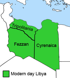
| BeschrijvingOttoman Provinces Of Present day Libya.png |
English: The Ottoman Turks conquered the country in the mid-16th century, and the three States or "Wilayat" of Tripolitania, Cyrenaica and Fezzan (which make up Libya) remained part of their empire with the exception of the virtual autonomy of the Karamanlis. The Karamanlis ruled from 1711 until 1835 mainly in Tripolitania, but had influence in Cyrenaica and Fezzan as well by the mid 18th century. |
|||
| Datum | ||||
| Bron | self-made but based on this image on this image and this image | |||
| Auteur | Esemono; improved by Kirk (talk) | |||
| Toestemming (Hergebruik van dit bestand) |
|
|||
| Andere versies |
Afgeleide werken van dit bestand:
   |
Bijschriften
Beschrijf in één regel wat dit bestand voorstelt
Items getoond in dit bestand
beeldt af
Bestandsgeschiedenis
Klik op een datum/tijd om het bestand te zien zoals het destijds was.
| Datum/tijd | Miniatuur | Afmetingen | Gebruiker | Opmerking | |
|---|---|---|---|---|---|
| huidige versie | 24 aug 2011 14:53 | | 282 × 314 (22 kB) | Kirk979 | See discussion |
| 11 apr 2011 22:46 |  | 300 × 350 (35 kB) | ANGELUS | border | |
| 11 apr 2011 22:35 |  | 300 × 350 (39 kB) | ANGELUS | improved | |
| 12 okt 2009 19:35 |  | 282 × 314 (22 kB) | Kirk979 | corrections | |
| 1 mrt 2009 13:00 |  | 282 × 314 (29 kB) | Kirk979 | corrections | |
| 17 apr 2008 15:43 |  | 282 × 314 (25 kB) | Esemono | Category:Maps of Libya Category:Map images that should use vector graphics |
Bestandsgebruik
Dit bestand wordt op de volgende 3 pagina's gebruikt:
Globaal bestandsgebruik
De volgende andere wiki's gebruiken dit bestand:
- Gebruikt op ar.wikipedia.org
- Gebruikt op azb.wikipedia.org
- Gebruikt op az.wikipedia.org
- Gebruikt op be.wikipedia.org
- Gebruikt op bg.wikipedia.org
- Gebruikt op bs.wikipedia.org
- Gebruikt op ca.wikipedia.org
- Gebruikt op cs.wikipedia.org
- Gebruikt op da.wikipedia.org
- Gebruikt op el.wikipedia.org
- Gebruikt op en.wikipedia.org
- Cyrenaica
- Districts of Libya
- Fezzan
- Tripolitania
- Governorates of Libya
- Subdivisions of Libya
- Provinces of Libya
- Postage stamps and postal history of Tripolitania
- Kingdom of Libya
- Postage stamps and postal history of Cyrenaica
- Postage stamps and postal history of Libya
- Postage stamps and postal history of Fezzan and Ghadames
- Template:Regions of Libya
- Category:Regions of Libya
- Revenue stamps of Libya
- Tripolitania (province of Libya)
- Cyrenaica province
- Fezzan province
Globaal gebruik van dit bestand bekijken.
Metadata
Dit bestand bevat metadata met EXIF-informatie, die door een fotocamera, scanner of fotobewerkingsprogramma toegevoegd kan zijn.
| Tijdstip laatste bestandswijziging | 12 okt 2009 17:34 |
|---|---|
| Horizontale resolutie | 28 dpc |
| Verticale resolutie | 28 dpc |