File:1900_Electoral_Map.png
Uit Wikipedia, de vrije encyclopedia
Grootte van deze voorvertoning: 800 × 430 pixels. Andere resoluties: 320 × 172 pixels | 640 × 344 pixels | 1.182 × 635 pixels.
Oorspronkelijk bestand (1.182 × 635 pixels, bestandsgrootte: 177 kB, MIME-type: image/png)
| Dit is een bestand van Wikimedia Commons. Onderstaande beschrijving komt van de beschrijving van het bestand daar. |
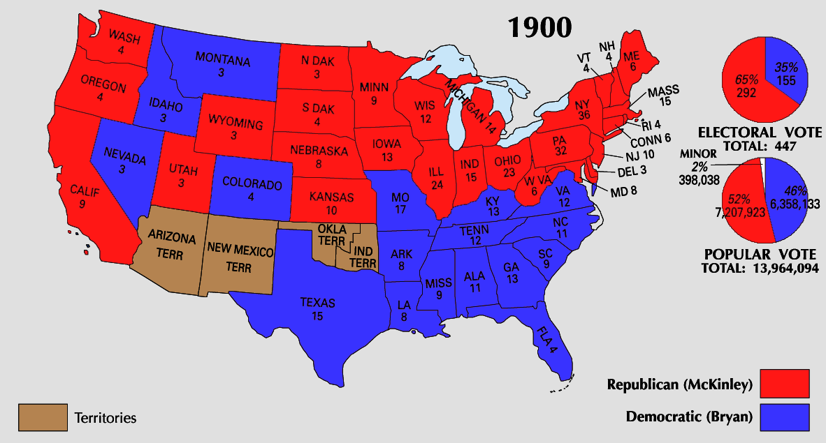
| U.S. presidential election maps from the National Atlas of the United States |
| See also: SVG maps |
| 1789 · 1792 · 1796 · 1800 · 1804 · 1808 · 1812 · 1816 · 1820 · 1824 · 1828 · 1832 · 1836 · 1840 · 1844 · 1848 · 1852 · 1856 · 1860 · 1864 · 1868 · 1872 · 1876 · 1880 · 1884 · 1888 · 1892 · 1896 · 1900 · 1904 · 1908 · 1912 · 1916 · 1920 · 1924 · 1928 · 1932 · 1936 · 1940 · 1944 · 1948 · 1952 · 1956 · 1960 · 1964 · 1968 · 1972 · 1976 · 1980 · 1984 · 1988 · 1992 · 1996 · 2000 · 2004 |
Beschrijving


Licentie
| Public domainPublic domainfalsefalse |
This map was obtained from an edition of the National Atlas of the United States. Like almost all works of the U.S. federal government, works from the National Atlas are in the public domain in the United States.
Online access: NationalAtlas.gov | 1970 print edition: Library of Congress, Perry-Castañeda Library čeština | Deutsch | English | français | Bahasa Indonesia | italiano | македонски | മലയാളം | sicilianu | 中文 | 中文(简体) | 中文(繁體) | +/− |
Bijschriften
Beschrijf in één regel wat dit bestand voorstelt
Items getoond in dit bestand
beeldt af
image/png
c3e47589fe0830cc04f228b795992944b31b06c2
181.182 byte
635 pixel
1.182 pixel
Bestandsgeschiedenis
Klik op een datum/tijd om het bestand te zien zoals het destijds was.
| Datum/tijd | Miniatuur | Afmetingen | Gebruiker | Opmerking | |
|---|---|---|---|---|---|
| huidige versie | 26 jun 2008 00:35 | | 1.182 × 635 (177 kB) | Tallicfan20 | |
| 24 jun 2008 06:51 |  | 1.182 × 635 (157 kB) | Tallicfan20 | ||
| 26 mei 2008 00:40 |  | 1.182 × 635 (147 kB) | Tallicfan20 | better quality | |
| 17 mei 2008 06:56 |  | 1.182 × 635 (101 kB) | Tallicfan20 | {{PD-USGov-Atlas}} |
Bestandsgebruik
Geen enkele pagina gebruikt dit bestand.
Globaal bestandsgebruik
De volgende andere wiki's gebruiken dit bestand:
- Gebruikt op de.wikipedia.org
- Gebruikt op en.wikipedia.org
- Gebruikt op sv.wikipedia.org
- Gebruikt op vi.wikipedia.org
- Gebruikt op zh.wikipedia.org
Metadata
Dit bestand bevat metadata met EXIF-informatie, die door een fotocamera, scanner of fotobewerkingsprogramma toegevoegd kan zijn.
| Horizontale resolutie | 28,35 dpc |
|---|---|
| Verticale resolutie | 28,35 dpc |
Overgenomen van "https://nl.wikipedia.org/wiki/Bestand:1900_Electoral_Map.png"