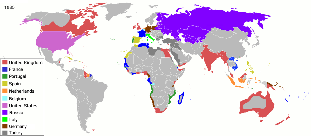
File:Colonisation_1885.png
Uit Wikipedia, de vrije encyclopedia
Oorspronkelijk bestand (1.200 × 526 pixels, bestandsgrootte: 206 kB, MIME-type: image/png)
| Dit is een bestand van Wikimedia Commons. Onderstaande beschrijving komt van de beschrijving van het bestand daar. |
| References for this description (or part of this) or for the depiction in the file are not provided. |
| BeschrijvingColonisation 1885.png |
Map of major world powers by year, derived from public domain animated map on wikipedia.
As the orriginal licence of the animation was Public Domain, this image which has been derived from it is too:
|
|||||||||||||||||||
| Datum | ||||||||||||||||||||
| Bron | public domain animated map by ArdadN here | |||||||||||||||||||
| Auteur | ArdadN | |||||||||||||||||||
.jpg)
._LOC_2001620596.jpg)

|
Deze kaartafbeelding zou opnieuw moeten worden aangemaakt als een SVG-bestand door vectorafbeeldingen te gebruiken. Dit heeft een aantal voordelen; zie Commons:Media for cleanup voor meer informatie. Als er een SVG-formaat van deze afbeelding bestaat, dan deze graag uploaden. Nadat u dit heeft gedaan, gelieve dit sjabloon te vervangen door het sjabloon {{vector version available|nieuwe bestandsnaam.svg}} op deze afbeeldingspagina.
|
Bijschriften
22 mrt 2007
image/png
831fd10c262a996a3291205f48ebb3278f0cca4d
210.626 byte
526 pixel
1.200 pixel
Bestandsgeschiedenis
Klik op een datum/tijd om het bestand te zien zoals het destijds was.
| Datum/tijd | Miniatuur | Afmetingen | Gebruiker | Opmerking | |
|---|---|---|---|---|---|
| huidige versie | 8 nov 2021 11:05 | | 1.200 × 526 (206 kB) | Randomastwritter | jubaland |
| 5 apr 2020 11:52 |  | 1.200 × 526 (206 kB) | Ориенталист | South Sakhalin was part of Russia in 1885 | |
| 2 mei 2015 13:17 |  | 1.425 × 625 (49 kB) | Chrischerf | German Empire and colonies in 1885; Sudan under control of the Mahdi | |
| 3 aug 2014 04:57 |  | 1.425 × 625 (54 kB) | Alvin Lee | correcting the boundaries of Russia and China | |
| 3 nov 2013 15:54 |  | 1.425 × 625 (78 kB) | McZusatz | Reverted to version as of 00:22, 24 January 2011 [corrupt file?] | |
| 3 nov 2012 17:24 |  | 1.425 × 625 (67 kB) | Franco310397 | Spanish presence in Micronesia (Oceania) included in the Captaincy General of the Philippines. In the Caroline Islands and the Mariana Islands. | |
| 24 jan 2011 02:22 |  | 1.425 × 625 (78 kB) | Micsha~commonswiki | Reverted to version as of 02:17, 3 May 2010 | |
| 24 jan 2011 02:22 |  | 506 × 326 (85 kB) | Micsha~commonswiki | Only Africa; includes map key | |
| 3 mei 2010 04:17 |  | 1.425 × 625 (78 kB) | Kieran4 | slight edit | |
| 3 mei 2010 04:14 |  | 1.425 × 625 (78 kB) | Kieran4 | Correct Dutch East INdies |
Bestandsgebruik
Geen enkele pagina gebruikt dit bestand.
Globaal bestandsgebruik
De volgende andere wiki's gebruiken dit bestand:
- Gebruikt op am.wikipedia.org
- Gebruikt op de.wikipedia.org
- Gebruikt op en.wikipedia.org
- Gebruikt op es.wikipedia.org
- Gebruikt op fr.wikipedia.org
- Gebruikt op he.wikipedia.org
- Gebruikt op oc.wikipedia.org
- Gebruikt op sk.wikipedia.org
Metadata
Dit bestand bevat metadata met EXIF-informatie, die door een fotocamera, scanner of fotobewerkingsprogramma toegevoegd kan zijn.
| Gebruikte software | |
|---|---|
| Horizontale resolutie | 47,24 dpc |
| Verticale resolutie | 47,24 dpc |
| Opmerking bij PNG-bestand |