File:Dissolution_of_Austria-Hungary.png
Uit Wikipedia, de vrije encyclopedia
Grootte van deze voorvertoning: 800 × 473 pixels. Andere resoluties: 320 × 189 pixels | 640 × 378 pixels | 1.024 × 605 pixels | 1.641 × 970 pixels.
Oorspronkelijk bestand (1.641 × 970 pixels, bestandsgrootte: 182 kB, MIME-type: image/png)
| Dit is een bestand van Wikimedia Commons. Onderstaande beschrijving komt van de beschrijving van het bestand daar. |

|
Deze kaartafbeelding zou opnieuw moeten worden aangemaakt als een SVG-bestand door vectorafbeeldingen te gebruiken. Dit heeft een aantal voordelen; zie Commons:Media for cleanup voor meer informatie. Als er een SVG-formaat van deze afbeelding bestaat, dan deze graag uploaden. Nadat u dit heeft gedaan, gelieve dit sjabloon te vervangen door het sjabloon {{vector version available|nieuwe bestandsnaam.svg}} op deze afbeeldingspagina.
|
| BeschrijvingDissolution of Austria-Hungary.png |
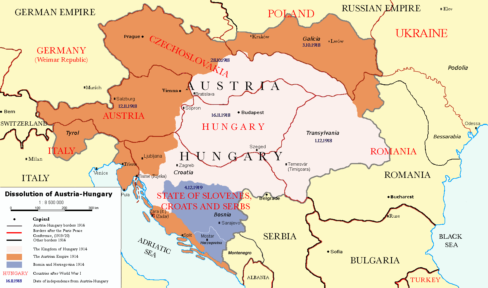
Čeština: Rozdělení Rakouska-Uherska po první světové válce, podle Pařížských předměstských smluv (Versailles s Německem, Saint-Germain-en-Laye s Rakouskem, Neuilly-sur-Seine s Bulharskem, Trianon s Maďarskem, Sèvres s Tureckem), dojednaných na Pařížské mírové konferenci (1919). Deutsch: Das Ende Österreich-Ungarns nach den Pariser Vorortverträgen. English: The end of Austria-Hungary after the Paris Treaty. |
| Datum | (UTC) |
| Bron | |
| Auteur |
|
| Andere versies | العربيَّة |
| Dit is een geretoucheerde foto, wat betekent dat de originele versie digitaal aangepast is. Aanpassingen: translated to english. Het origineel kan hier bekeken worden: Österreich-Ungarns Ende.png. Aanpassingen gedaan door P. S. Burton.
|
Ik, de auteursrechthebbende van dit werk, maak het hierbij onder de volgende licenties beschikbaar:
| Dit bestand is gelicenseerd onder de Creative Commons-licentie Naamsvermelding-Gelijk delen 3.0 Unported | ||
| ||
| Deze licentietag is toegevoegd aan dit bestand in verband met de GFDL licentie-update.http://creativecommons.org/licenses/by-sa/3.0/CC BY-SA 3.0Creative Commons Attribution-Share Alike 3.0truetrue |

|
Toestemming wordt verleend voor het kopiëren, verspreiden en/of wijzigen van dit document onder de voorwaarden van de GNU-licentie voor vrije documentatie, versie 1.2 of enige latere versie als gepubliceerd door de Free Software Foundation; zonder Invariant Sections, zonder Front-Cover Texts, en zonder Back-Cover Texts. Een kopie van de licentie is opgenomen in de sectie GNU-licentie voor vrije documentatie.http://www.gnu.org/copyleft/fdl.htmlGFDLGNU Free Documentation Licensetruetrue |
U mag zelf één van de licenties kiezen.
Oorspronkelijk uploadlogboek
This image is a derivative work of the following images:
- File:Österreich-Ungarns_Ende.png licensed with Cc-by-sa-3.0-migrated, GFDL
- 2007-07-16T11:59:46Z Nihad Hamzic 1568x970 (81916 Bytes) The original image seems to had been saved as JPEG, and that some previous uploader had simply directly converted it to PNG. I have greatly optimised its size by removing JPEG artifacts, reducing color domain, etc.
- 2006-01-23T20:47:06Z AlphaCentauri 1568x970 (924912 Bytes) kleine Änderungen
- 2005-09-23T14:27:32Z AlphaCentauri 1568x970 (924912 Bytes) Laibach and Triest
- 2005-09-17T03:29:55Z Berkut 1568x970 (355556 Bytes) better file compression
- 2005-09-16T09:39:55Z Kallgan 1568x970 (438065 Bytes) Das Ende Österreich-Ungarns nach dem Pariser Vorortverträgen. Selbsterstellte Karte. {{Bild-GFDL}} (Borders between Romania and Bulgaria in Dobrogea modified)(Source: Goode's World Atlas, Rand McNally & Company, 1932 & 19
- 2005-07-04T13:39:25Z AlphaCentauri 1568x970 (924912 Bytes) verbessert
- 2005-04-28T19:29:14Z AlphaCentauri 1568x970 (924912 Bytes) so, nochmals verbessert
- 2005-04-12T18:45:25Z AlphaCentauri 1568x970 (924912 Bytes) nochmals verbessert
- 2005-04-12T15:06:42Z AlphaCentauri 1568x970 (924912 Bytes)
- 2005-04-12T14:47:08Z AlphaCentauri 1568x970 (924912 Bytes) verbesserte Version
- 2005-01-05T20:59:50Z AlphaCentauri 1568x970 (924912 Bytes) verbesserte Version
- 2004-12-29T10:14:48Z AlphaCentauri 1568x970 (924912 Bytes) Das Ende Österreich-Ungarns (Karte)
Uploaded with derivativeFX
Bijschriften
Beschrijf in één regel wat dit bestand voorstelt
Items getoond in dit bestand
beeldt af
23 nov 2010
1914
image/png
Bestandsgeschiedenis
Klik op een datum/tijd om het bestand te zien zoals het destijds was.
| Datum/tijd | Miniatuur | Afmetingen | Gebruiker | Opmerking | |
|---|---|---|---|---|---|
| huidige versie | 26 dec 2021 19:57 | | 1.641 × 970 (182 kB) | Claude Zygiel | Cosmetic and correct romanian-ukrainian border since April 9, 1918 |
| 6 dec 2020 18:27 |  | 1.568 × 970 (175 kB) | Crash48 | before 1919, the Greek-Bulgarian border was far to the southwest | |
| 3 dec 2020 20:08 |  | 1.568 × 970 (175 kB) | Crash48 | Lwów didn't become Lviv until 1939 | |
| 2 dec 2020 18:37 |  | 1.568 × 970 (148 kB) | Crash48 | Romanian-Ukrainian border was way off; fixed according to File:Romania1901.JPG | |
| 10 mrt 2020 17:20 |  | 1.568 × 970 (229 kB) | Kufl | Odessa was never part of the Romania at that time | |
| 10 okt 2013 17:58 |  | 1.568 × 970 (163 kB) | Lvivske | Incorrectly states that Ukraine was the Russian SFSR (Russia is not seen on the map), the area of Ukraine was the Ukraine post-WW1 and later following another war, the Ukrainian Soviet Socialist Republic, and joined ... | |
| 24 nov 2010 23:36 |  | 1.568 × 970 (164 kB) | P. S. Burton | Ungarn ->Hungary etc. | |
| 23 nov 2010 23:46 |  | 1.568 × 970 (163 kB) | P. S. Burton | Zara -> Zara (Zadar) | |
| 23 nov 2010 23:41 |  | 1.568 × 970 (163 kB) | P. S. Burton | Black Sea ->BLACK SEA | |
| 23 nov 2010 23:39 |  | 1.568 × 970 (163 kB) | P. S. Burton | {{Information |Description={{cs|Rozdělení Rakouska-Uherska po první světové válce, podle Pařížských předměstských smluv ([[:cs:Versailles|Ver |
Bestandsgebruik
Geen enkele pagina gebruikt dit bestand.
Globaal bestandsgebruik
De volgende andere wiki's gebruiken dit bestand:
- Gebruikt op ar.wikipedia.org
- Gebruikt op azb.wikipedia.org
- Gebruikt op ba.wikipedia.org
- Gebruikt op ca.wikipedia.org
- Gebruikt op de.wikipedia.org
- Gebruikt op el.wikipedia.org
- Gebruikt op en.wikipedia.org
- Austria-Hungary
- Nation state
- Dalmatia
- Aftermath of World War I
- Treaty of Saint-Germain-en-Laye (1919)
- World War I
- Anschluss
- Key events of the 20th century
- Wikipedia:Graphics Lab/Map workshop/Archive/Dec 2010
- Green Cadres
- Dissolution of Austria-Hungary
- Austria victim theory
- User:Lord Milner/Lord Milner Timeline
- User:Lord Milner/sandbox/Lord Milner's Life Timeline
- Draft:Timeline of Alfred Milner
- User:Falcaorib/Austria-Hungary
- Gebruikt op fr.wikipedia.org
- Gebruikt op he.wikipedia.org
- Gebruikt op hr.wikipedia.org
- Gebruikt op hy.wikipedia.org
- Gebruikt op id.wikipedia.org
- Gebruikt op io.wikipedia.org
- Gebruikt op it.wikipedia.org
- Gebruikt op lmo.wikipedia.org
- Gebruikt op lt.wikipedia.org
- Gebruikt op no.wikipedia.org
- Gebruikt op pnb.wikipedia.org
- Gebruikt op pt.wikipedia.org
- Gebruikt op ro.wikipedia.org
- Gebruikt op sh.wikipedia.org
- Gebruikt op sv.wikipedia.org
Globaal gebruik van dit bestand bekijken.
Metadata
Dit bestand bevat metadata met EXIF-informatie, die door een fotocamera, scanner of fotobewerkingsprogramma toegevoegd kan zijn.
| Horizontale resolutie | 37,8 dpc |
|---|---|
| Verticale resolutie | 37,8 dpc |
Overgenomen van "https://nl.wikipedia.org/wiki/Bestand:Dissolution_of_Austria-Hungary.png"