
St. Osyth
plaats in Essex / Uit Wikipedia, de vrije encyclopedia
St Osyth is een civil parish in het bestuurlijke gebied Tendring, in het Engelse graafschap Essex. De plaats telt 4277 inwoners.
 St. Osyth
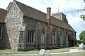 Kerk van St. Peter en St. Paul, St. Osyth


Geplaatst op: 14-07-2007 |
Dit artikel is een beginnetje over landen & volken. U wordt uitgenodigd om op bewerken te klikken om uw kennis aan dit artikel toe te voegen. |
Snelle feiten Situering, Regio ...
| Civil parish in Engeland | |||
|---|---|---|---|
 | |||
| Situering | |||
| Regio | East of England | ||
| Graafschap | Essex | ||
| District | Tendring | ||
| Coördinaten | 51° 48' NB, 1° 5' OL | ||
| Algemeen | |||
| Oppervlakte | 32,2110 km² | ||
| Inwoners (2011) |
4277 (133 inw./km²) | ||
| Overig | |||
| Postcode(s) | CO16 | ||
| Netnummer(s) | 01255 | ||
| Grid code | TM123156 | ||
| ONS-code | E04004108 | ||
| Foto's | |||
 | |||
| Priorij van St. Osyth | |||
| |||
Sluiten