Figura:Karte_Deutschland.png
From Wikipedia, the free encyclopedia
Gnun-a risolussion pì bela disponìbil.
Karte_Deutschland.png (188 × 235 pontin, amzure: 2 KByte, sòrt MIME: image/png)
Cost archivi a riva da Wikimedia Commons e a peul esse dovrà da dj'àutri proget. La descrission an soa pàgina ëd dëscrission ëd l'archivi a l'é smonùa sì-sota.
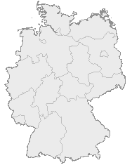
| DescrissionKarte Deutschland.png |
English: Map of Germany with the borders of the 16 federal states.
Deutsch: Karte von Deutschland mit den Grenzen der 16 Bundesländer. |
| Data |
Data nen conossùa Unknown date |
| Sorgiss | OpenGeoDB |
| Autor | NN/OpenGeoDB |
| Përmess (Riusagi ëd cost archivi) |
GFDL |
This image was generated with OpenGeoDB. The information there is placed in the public domain, images generated from OpenGeoDB are derivative works without passing the threshold of creativity, they are therefore also public domain.
| Public domainPublic domainfalsefalse |
| Questa immagine non possiede i requisiti per essere soggetta a copyright ed è quindi nel pubblico dominio, poiché è costituita interamente da informazioni che sono proprietà comune e non contiene condizione dell'autore originale. |

|
File:Germany location map.svg è una versione vettoriale di questo file. Dovrebbe essere usata quella versione al posto di questo file PNG, quando sia migliore.
File:Karte Deutschland.png → File:Germany location map.svg
Per maggiori informazioni, vedi Help:SVG.
|
 |
Stòria dl'archivi
Ch'a-i daga un colp col rat ant sna cobia data/ora për ës-ciairé coma a restèissa l'archivi ant col moment-là.
| Data e Ora | Miniadura | Amzure | Utent | Coment | |
|---|---|---|---|---|---|
| dël dì d'ancheuj | 20:46, 8 gen 2008 | | 188 × 235 (2 KByte) | Evilboy | Reverted to version as of 20:35, 14 March 2007 |
| 22:35, 14 mar 2007 |  | 188 × 235 (2 KByte) | Tene~commonswiki | Optimised (0) | |
| 13:28, 9 Fër 2007 |  | 188 × 235 (2 KByte) | TMg | Contrast slightly improved without loosing precision | |
| 21:04, 31 gen 2007 |  | 188 × 235 (2 KByte) | Leit | Auf eine alte Version zurückgesetzt | |
| 20:17, 31 gen 2007 |  | 188 × 235 (8 KByte) | Der Eberswalder | ||
| 14:29, 31 gen 2007 |  | 188 × 235 (2 KByte) | Rauenstein | Auf eine alte Version zurückgesetzt | |
| 13:04, 31 gen 2007 |  | 188 × 235 (8 KByte) | Der Eberswalder | now white color outside the borders | |
| 12:31, 31 gen 2007 |  | 188 × 235 (2 KByte) | Siebrand | Eerdere versie hersteld | |
| 08:31, 31 gen 2007 |  | 188 × 235 (9 KByte) | Der Eberswalder | better viewable | |
| 17:48, 27 Aos 2006 |  | 188 × 235 (2 KByte) | TMg | Slightly error corrected version, based on Image:Karte stralsund in deutschland-test.png by de:Benutzer:Rauenstein |
Anliure a le figure
Le pàgine sì-sota a l'han andrinta dj'anliure a sta figura-sì:
- Altlandsberg
- Ammerndorf
- Ammerthal
- Bad Schwalbach
- Baudenbach
- Billigheim
- Birenbach
- Bodnegg
- Bösingen (Friburgh)
- Ebermannsdorf
- Eggingen
- Engelthal
- Fahrenbach
- Fichtelberg
- Fluorn-Winzeln
- Freudental
- Gechingen
- Graben-Neudorf
- Grafenau
- Hahnbach
- Hambrücken
- Hattenhofen
- Hohenstein
- Hohentengen
- Horben
- Horgenzell
- Iffezheim
- Kronau
- Lichtenwald
- Mainleus
- Marloffstein
- Marxzell
- Mehrstetten
- Mistelbach
- Möglingen
- Neuhaus
- Nordheim (Württemberg)
- Nusplingen
- Obersulm
- Pemfling
- Pommersfelden
- Riederich
- Runding
- Römerstein
- Röttenbach (Erlangen)
- Salach
- Sankt Märgen
- Schlaitdorf
- Schlier
- Schnaittach
- Schotten
- Schwaig
- Schwarzenbruck
- Schöntal
- Spiegelberg
- Stegen
- Unterensingen
- Unterreichenbach
- Velten
- Viereth-Trunstadt
- Walzbachtal
- Weissach
- Weisweil
- Wiesenthau
- Wimsheim
- Wollershausen
- Zandt
- Zell unter Aichelberg
Dovragi global dël file
J'àutre wiki sì sota a deuvro st'archivi-sì:
- Usagi dzora ceb.wikipedia.org
- Usagi dzora da.wikipedia.org
- Usagi dzora de.wikipedia.org
- Usagi dzora nds.wikipedia.org
- Landkreis Emsland
- Landkreis Rodenborg (Wümm)
- Landkreis Stood
- Landkreis Heidkreis
- Landkreis Vechte
- Landkreis Veern
- Kreis Noordfreesland
- Landkreis Cuxhoben
- Landkreis Oosterholt
- Landkreis Horborg
- Landkreis Lümborg
- Kreis Pinnbarg
- Landkreis Ollnborg
- Kreis Steenborg
- Landkreis Weißenburg-Gunzenhausen
- Landkreis Würzburg
- Landkreis Wunsiedel im Fichtelgebirge
- Landkreis Weilheim-Schongau
- Landkreis Unterallgäu
- Landkreis Traunstein
- Landkreis Tirschenreuth
- Landkreis Straubing-Bogen
- Landkreis Starnberg
- Landkreis Schweinfurt
- Landkreis Schwandorf
- Landkreis Rottal-Inn
- Landkreis Roth
- Landkreis Rosenheim
- Landkreis Rhön-Grabfeld
- Landkreis Paane
- Landkreis Wulfenbüttel
- Landkreis Groafschup Bentem
- Landkreis Hameln-Purmunt
- Landkreis Aichach-Friedberg
- Landkreis Altötting
- Landkreis Amberg-Sulzbach
- Landkreis Schaumborg
- Landkreis Ülzen
- Landraodsamt Stemmert
- Usagi dzora pt.wikipedia.org
Varda l'usagi global dë st'archivi-sì.