Файл:KatrinaNewOrleansFlooded_edit2.jpg
Материал из Википедии — свободной encyclopedia
Исходный файл (1153 × 1514 пкс, размер файла: 1,23 Мб, MIME-тип: image/jpeg)
Этот файл находится на Викискладе. Сведения о нём показаны ниже.
Викисклад — централизованное хранилище для свободных файлов, используемых в проектах Викимедиа.
Сообщить об ошибке с файлом |
Краткое описание
| ОписаниеKatrinaNewOrleansFlooded edit2.jpg |
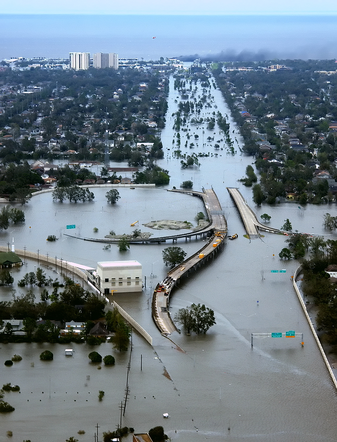
English: New Orleans, Louisiana in the aftermath of Hurricane Katrina (2005:08:29 17:24:22), showing Interstate 10 at West End Boulevard, looking towards Lake Pontchartrain.
The 17th Street Canal is just beyond the left edge of the image. The breach in the levee of that canal was responsible for much of the flooding of the city in the hours after the hurricane. In the foreground, the intersection is the juncture of I-10, running from the bottom of the photo and curving out of the photo to the left, with the western end of I-610, which extends off the photo from the center right, and the West End entrance/exit from I-10. The block shaped building at center left front is a pumping station, one of those used to pump water from heavy rains off city streets in more normal times. The far eastern end of Veterans Memorial Boulevard is seen just back from the interchange extending to the left. The view looks north toward Lake Pontchartrain. The stretch of ground with no buildings from the Interchange to the lake is Pontchartrain Blvd. (on the left) and West End Blvd. (on the right), with a linear park (formerly the route of the New Basin Canal) between them. Smoke can be seen rising near the lake, probably from the burning of the Southern Yacht Club building. This photo provided by the U.S. Coast Guard shows flooded roadways as the Coast Guard conducted initial Hurricane Katrina damage assessment overflights of New Orleans, Monday Aug. 29, 2005. Edit, selective noise reduction by MfieldDeutsch: Das überflutete New Orleans
Español: Carretera Interestatal 10 en Nueva Orleans inundada después del paso del huracán Katrina a finales de agosto de 2005. La inundación se provocó por una brecha en el dique de contención durante el paso del huracán.
Suomi: 80% New Orleansista jäi veden alle, kun hurrikaani Katrina iski Yhdysvaltain rannikolle elokuussa 2005
Türkçe: Sel altında kalan I-10/I-610/West End Bulvarlarının kesiştiği kavşak, kuzeybatı New Orleans ve Metairie, Louisiana. |
||||
| Дата | |||||
| Источник | Published here, here, and here | ||||
| Автор | AP Photo/U.S. Coast Guard, Petty Officer 2nd Class Kyle Niemi | ||||
| Права (Повторное использование этого файла) |
|
||||
| Другие версии |
|

Оценка
|
Краткие подписи
Элементы, изображённые на этом файле
изображённый объект
29 августа 2005
image/jpeg
История файла
Нажмите на дату/время, чтобы посмотреть файл, который был загружен в тот момент.
| Дата/время | Миниатюра | Размеры | Участник | Примечание | |
|---|---|---|---|---|---|
| текущий | 03:26, 18 апреля 2008 | | 1153 × 1514 (1,23 Мб) | Mfield | == Summary == {{Information |Description=New Orleans, Louisiana in the aftermath of Hurricane Katrina (2005:08:29 17:24:22), showing Interstate 10 at West End Boulevard, looking towards Lake Pontchartrain. The 17th Street Canal is just beyond the left e |
Использование файла
Следующие 3 страницы используют этот файл:
Глобальное использование файла
Данный файл используется в следующих вики:
- Использование в ar.wikipedia.org
- Использование в ast.wikipedia.org
- Использование в az.wiktionary.org
- Использование в ba.wikipedia.org
- Использование в be.wikipedia.org
- Использование в bg.wikipedia.org
- Использование в bs.wikipedia.org
- Использование в bxr.wikipedia.org
- Использование в ca.wikipedia.org
- Использование в cv.wikipedia.org
- Использование в cy.wikipedia.org
- Использование в dag.wikipedia.org
- Использование в de.wiktionary.org
- Использование в el.wikipedia.org
- Использование в en.wikipedia.org
- 2000s
- Wikipedia:Selected anniversaries/August 29
- 2005 Atlantic hurricane season
- User:E. Brown
- Habitat destruction
- User talk:Spikebrennan
- User:Spikebrennan
- Hurricane Katrina
- Effects of Hurricane Katrina in New Orleans
- User:UniReb
- Pontchartrain Expressway
- Wikipedia:WikiProject Tropical cyclones
- User:Nemalki
- User:Canuck85
- User:Lionheart Omega
- User:UBX/remember Katrina
- User:Robomaeyhem
- User talk:Hurricanehink/Archive 2
- User:VerruckteDan
- User:Omni ND/Userboxes
- User:Lavishluau
- User:Eastlaw/UBX
- User:Krzysiu Jarzyna
- User:Samwisep86
Просмотреть глобальное использование этого файла.
Метаданные
Файл содержит дополнительные данные, обычно добавляемые цифровыми камерами или сканерами. Если файл после создания редактировался, то некоторые параметры могут не соответствовать текущему изображению.
| Ориентация кадра | Нормальная |
|---|---|
| Горизонтальное разрешение | 72 точек на дюйм |
| Вертикальное разрешение | 72 точек на дюйм |
| Программное обеспечение | Adobe Photoshop CS3 Macintosh |
| Дата и время изменения файла | 20:24, 17 апреля 2008 |
| Цветовое пространство | sRGB |