File:MapaSageo-Guayas-02.png
From Wikipedia, the free encyclopedia
Size o this luikower: 433 × 599 pixels. Ither resolutions: 173 × 240 pixels | 347 × 480 pixels | 702 × 971 pixels.
Oreeginal file (702 × 971 pixels, file size: 55 KB, MIME type: image/png)
This file is fae Wikimedia Commons n micht be uised bi ither waurks. The descreeption oan its file descreeption page thaur is shawn ablo.
Ootline
| DescreeptionMapaSageo-Guayas-02.png |
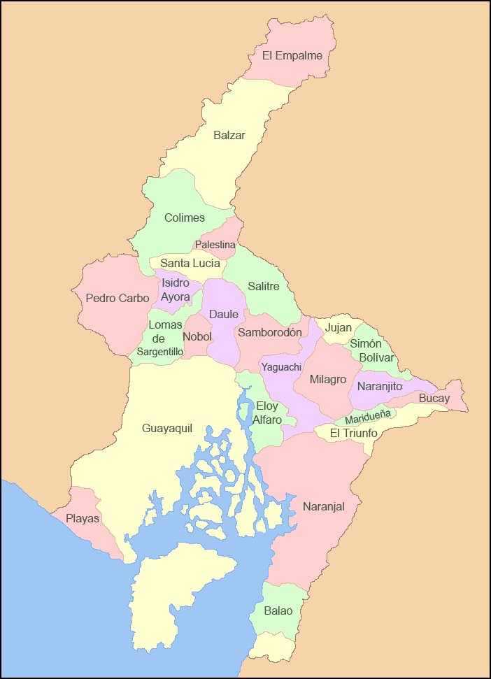
Español: Mapa de los cantones de la Provincia del Guayas |
| Date | |
| Soorce | Ain wirk |
| Author | Sageo |
Licensin
I, the copyright holder of this work, hereby publish it under the following licenses:

|
Permission is grantit tae copy, distribute an/or modify this document unner the terms o the GNU Free Documentation License, Version 1.2 or ony later version published bi the Free Software Foundation; wi no Invariant Sections, no Front-Cover Texts, an no Back-Cover Texts. A copy o the license is includit in the section enteetled GNU Free Documentation License.http://www.gnu.org/copyleft/fdl.htmlGFDLGNU Free Documentation Licensetruetrue |
This file is licensed under the Creative Commons Attribution-Share Alike Attribution-Share Alike 4.0 International, 3.0 Unported, 2.5 Generic, 2.0 Generic and 1.0 Generic license.
- Ye are free:
- tae share – tae copy, distribute an transmit the wirk
- tae remix – tae adapt the wirk
- Unner the follaein condeetions:
- attribution – Ye must attribute the wirk in the manner specified bi the author or licensor (but nae in ony way that suggests that thay endorse ye or yer uise o the wirk).
- share alik – If ye alter, transform, or big upon this wirk, ye mey distribute the resultin wirk anly unner the same or seemilar license tae this ane.
Ye mey select the license o yer choice.
Captions
Add a one-line explanation of what this file represents
Items portrayed in this file
depicts
some value
copyright status Inglis
copyrighted Inglis
source of file Inglis
5 Mairch 2009
File history
Clap oan ae date/time fer tae see the file aes it kithed at that time.
| Date/Time | Thummnail | Dimensions | Uiser | Comment | |
|---|---|---|---|---|---|
| current | 05:22, 5 Mairch 2009 | | 702 × 971 (55 KB) | Sageo | {{Information |Description={{es|1=Mapa de los cantones de la Provincia del Guayas}} |Source=trabajo propio (own work) |Author=Sageo |Date=5 de marzo de 2009 |Permission= |other_versions= }} <!--{{ImageUpload|full}}--> Category:Guayas |
Eimage airtins
The follaein pages airts tae this image:
Global file uisage
The follaein ither wikis uise this file:
- Uisage on ar.wikipedia.org
- Uisage on arz.wikipedia.org
- Uisage on ca.wikipedia.org
- Uisage on ceb.wikipedia.org
- Uisage on cs.wikipedia.org
- Uisage on de.wikipedia.org
- Uisage on en.wikipedia.org
- Guayas Province
- Pedro Carbo
- Guayaquil Canton
- Naranjal Canton
- Alfredo Baquerizo Moreno Canton
- Balao Canton
- El Empalme Canton
- El Triunfo Canton
- General Antonio Elizalde Canton
- Isidro Ayora Canton
- Lomas de Sargentillo Canton
- Milagro Canton
- Naranjito Canton
- Palestina Canton
- Pedro Carbo Canton
- Playas Canton
- Samborondón Canton
- Santa Lucía Canton
- Simón Bolívar Canton
- Yaguachi Canton
- Uisage on es.wikipedia.org
- Uisage on eu.wikipedia.org
- Uisage on fa.wikipedia.org
- Uisage on id.wikipedia.org
- Uisage on incubator.wikimedia.org
View mair global usage o this file.
Metadata
This file contains addeetional information, likelie eikit fae the deegital camera or scanner uised tae cræft or deegitise it.
Gif the file haes bin modeefied fae its oreeginal state, some details micht na fullie reflect the modeefied file.
| Horizontal resolution | 59.06 dpc |
|---|---|
| Verteecal resolution | 59.06 dpc |