File:Asia_satellite_plane_shaded.jpg
From Wikipedia, the free encyclopedia
Asia_satellite_plane_shaded.jpg (800 × 464 pixels, weyninka faylka : 84 KB, nuuca MIME: image/jpeg)
Faylkaan wuxuu ka socdaa Wikimedia Commons waxaana adeegsan kara mashaariic kale. Sharaxaadda ku taal boggeeda faylka ee bogga sharaxaadda faylka halkan hoose ayaa lagu muujiyey.
Qoraal kooban
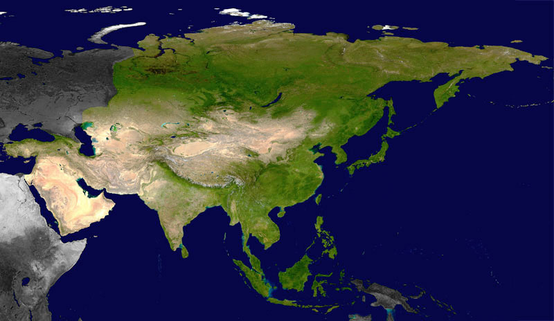
| SharaxaadAsia satellite plane shaded.jpg |
Satellite view of the Asian continent |
| Taariikhda | |
| Xigasho | A modified version (non Asiatic continents shaded) of Image:Asia_satellite_plane.jpg (NASA image) |
| Qoraa | of the modification : Eric Gaba (Sting) |
| Ogolaasho (Dib u isticmaalka faylkaan) |
PD |
| Other versions | original image : Image:Asia_satellite_plane.jpg |
This map was improved or created by the Wikigraphists of the Graphic Lab (fr). You can propose images to clean up, improve, create or translate as well. |
Laysinka
| Public domainPublic domainfalsefalse |
| This file is in the public domain in the United States because it was solely created by NASA. NASA copyright policy states that "NASA material is not protected by copyright unless noted". (See Template:PD-USGov, NASA copyright policy page or JPL Image Use Policy.) | ||
 |
Warnings:
|
Captions
Items portrayed in this file
depicts Ingiriisi
inception Ingiriisi
Nofeembar 2006
media type Ingiriisi
image/jpeg
checksum Ingiriisi
aea78de7162daa6faca8ecf36405a745072b0373
data size Ingiriisi
86,496 byte
height Ingiriisi
464 pixel
width Ingiriisi
800 pixel
Taariikhda faylka
Riix taariikhda/waqtiga si aad u argto faylka sida oo ahaa markiisa hore.
| Taariikhda/Waqtiga | Sawir yar | Cabirka | Isticmaale | Ka hadalka | |
|---|---|---|---|---|---|
| kan hadda | 09:45, 3 Febraayo 2009 | | 800 × 464 (84 KB) | Koyos | reverting geographically inaccurate color coding |
| 13:59, 18 Luuliyo ama Luulyo 2008 |  | 800 × 464 (62 KB) | Aegean Boy~commonswiki | {{Information |Description= |Source= |Date= |Author= |Permission= |other_versions= }} | |
| 01:41, 18 Nofeembar 2006 |  | 800 × 464 (84 KB) | Sting | {{Information| |Description=Satellite view of the Asian continent<br/> |Source= A modified version (non-Asian continents shaded) of Image:Asia_satellite_plane.jpg (NASA image) |Date=November 2006 |Author=of the modification : Eric Gaba ([[User:Sting| |
Faylka lagu isticmaalay
waxyaabaha soo socda ee 2 boggag ayaa isticmaalaya faylkaan:
isticmaalka faylka aduunka
Wikisyada kale ee soosocda ayaa adeegsanaya faylka:
- Ku isticmaal an.wikipedia.org
- Ku isticmaal ar.wikipedia.org
- Ku isticmaal ca.wikipedia.org
- Ku isticmaal de.wikipedia.org
- Ku isticmaal en.wikipedia.org
- Ku isticmaal es.wikipedia.org
- Ku isticmaal fr.wikipedia.org
- Ku isticmaal gcr.wikipedia.org
- Ku isticmaal id.wikipedia.org
- Ku isticmaal incubator.wikimedia.org
- Ku isticmaal io.wikipedia.org
- Ku isticmaal it.wiktionary.org
- Ku isticmaal kab.wikipedia.org
- Ku isticmaal kbp.wikipedia.org
- Ku isticmaal ky.wikipedia.org
- Ku isticmaal pa.wikipedia.org
- Ku isticmaal pcd.wikipedia.org
- Ku isticmaal shi.wikipedia.org
- Ku isticmaal sq.wikipedia.org
- Ku isticmaal tr.wikipedia.org
- Ku isticmaal vec.wiktionary.org
- Ku isticmaal vi.wikipedia.org
Metadata
Faylkani wuxuu ka kooban yahay macluumaad dheeri ah, oo laga yaabo inuu ku daray kamaradda dijitaalka ama scanner oo loo isticmaalay in lagu abuuro ama lagu dijitilaasgareeyo.
Haddii faylka wax laga beddelay xaaladdiisii hore, faahfaahinta qaar lagama yaabo inay si buuxda u muujiyaan faylka wax laga beddelay.
| Orientation | Normal |
|---|---|
| Horizontal resolution | 72 dpi |
| Vertical resolution | 72 dpi |
| Software used | Adobe Photoshop 7.0 |
| File change date and time | 23:30, 17 Nofeembar 2006 |
| Color space | Uncalibrated |