فائل:3D_locations_in_Google_Earth.png
From Wikipedia, the free encyclopedia
اس نمائش کا حجم: 800 × 410 پکسلز۔ دیگر تصمیمات: 320 × 164 پکسلز | 640 × 328 پکسلز | 1,436 × 736 پکسلز۔
اصل فائل (1,436 × 736 پکسل، فائل کا حجم: 51 کلوبائٹ، MIME قسم: image/png)
یہ فائل ویکی ذخائر کی ہے اور دیگر منصوبوں کے زیر استعمال ہوسکتی ہے۔ فائل کے صفحہ تعارف پر موجود تعارف ذیل میں موجود ہے۔
خلاصہ
| تفصیل3D locations in Google Earth.png |
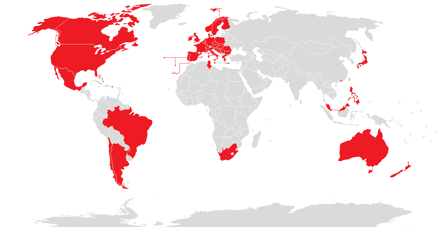
English: Countries which have regions available in Google Earth as a three dimensional model |
| تاریخ | |
| ماخذ | ذاتی کام |
| مصنف | Eugen Simion 14 |

|
File:3D locations in Google Earth.svg is a vector version of this file. It should be used in place of this PNG file when not inferior.
File:3D locations in Google Earth.png → File:3D locations in Google Earth.svg
For more information, see Help:SVG.
|
 |
اجازہ کاری
میں اس تخلیقی کام کے حقوق کا مالک ہوں اور اسے مندرجہ ذیل اجازت نامے کے تحت شائع کرتا ہوں:
| This file is made available under the Creative Commons CC0 1.0 Universal Public Domain Dedication. | |
| The person who associated a work with this deed has dedicated the work to the public domain by waiving all of their rights to the work worldwide under copyright law, including all related and neighboring rights, to the extent allowed by law. You can copy, modify, distribute and perform the work, even for commercial purposes, all without asking permission.
http://creativecommons.org/publicdomain/zero/1.0/deed.enCC0Creative Commons Zero, Public Domain Dedicationfalsefalse |
Captions
Add a one-line explanation of what this file represents
Items portrayed in this file
عکاسی
some value
14 مئی 2015
source of file انگریزی
original creation by uploader انگریزی
media type انگریزی
image/png
checksum انگریزی
dfa528c13d340d6f1f44c6dcf615fa53a15dbe3a
data size انگریزی
51,761 لکمہ
736 عکصر
1,436 عکصر
فائل کا تاریخچہ
کسی خاص وقت یا تاریخ میں یہ فائل کیسی نظر آتی تھی، اسے دیکھنے کے لیے اس وقت/تاریخ پر کلک کریں۔
| تاریخ/وقت | تھمب نیل | ابعاد | صارف | تبصرہ | |
|---|---|---|---|---|---|
| رائج الوقت | 23:26، 1 نومبر 2019ء | | 1,436 × 736 (51 کلوبائٹ) | Owen313 | New 3D Maps in Serbia. Pink means countries with former 3D Maps (Taiwan). |
| 23:07، 25 فروری 2019ء |  | 1,436 × 736 (51 کلوبائٹ) | Owen313 | Google just removed the 3D rendered maps in Taiwan after security concerns. | |
| 01:46، 17 فروری 2019ء |  | 1,436 × 736 (51 کلوبائٹ) | Owen313 | wait. i don't think i added it in right. | |
| 01:44، 17 فروری 2019ء |  | 1,436 × 736 (52 کلوبائٹ) | Owen313 | Added in Taiwan. | |
| 15:00، 3 اگست 2018ء |  | 1,436 × 736 (76 کلوبائٹ) | Lejames18 | Added The Bahamas, Macau, San Marino, and Singapore. | |
| 15:23، 2 اگست 2018ء |  | 1,436 × 736 (75 کلوبائٹ) | Lejames18 | Added Monaco | |
| 23:43، 1 اگست 2018ء |  | 1,436 × 736 (75 کلوبائٹ) | Lejames18 | Added Slovakia | |
| 17:44، 30 جولائی 2018ء |  | 1,436 × 736 (75 کلوبائٹ) | Lejames18 | Added Bosnia and Herzegovina. [https://en.m.wikipedia.org/wiki/Brod,_Bosnia_and_Herzegovina Brod] | |
| 05:21، 28 جنوری 2018ء |  | 1,436 × 736 (48 کلوبائٹ) | Stormocean | Deleted Slovakia; added Malaysia, Tunisia, Malta, and Puerto Rico; updated in Jan 2018 | |
| 11:10، 22 جنوری 2016ء |  | 1,436 × 736 (52 کلوبائٹ) | Eugen Simion 14 | update |
روابط
درج ذیل صفحہ اس فائل کو استعمال کر رہا ہے:
فائل کا عالمی استعمال
مندرجہ ذیل ویکیوں میں یہ فائل زیر استعمال ہے:
- es.wikipedia.org پر استعمال
- it.wikipedia.org پر استعمال
- zh.wikipedia.org پر استعمال
میٹا ڈیٹا
اِس فائل میں اِضافی معلومات شامل ہیں، جو شاید اُس ڈیجیٹل کیمرے یا اِسکینر سے آئی ہیں جس کے ذریعے یہ فائل بنائی گئی تھی۔
اگر فائل اپنی اصل حالت میں نہ ہو تو کچھ معلومات ترمیم شدہ فائل کی مکمل طور پر عکاسی نہیں کر پائیں گی۔
| افقی ریزولوشن | 37.79 dpc |
|---|---|
| عمودی ریزولیشن | 37.79 dpc |