Imådje:Arrondissement_Nivelles_Belgium_Map.png
From Wikipedia, the free encyclopedia
I n’ a nén di pus grande finté.
Arrondissement_Nivelles_Belgium_Map.png (190 × 95 picsels, groxheur do fitchî: 2 Ko, del sôre "MIME": image/png)
Ci fitchî ci provént d’ Wikimedia Commons ; si pout i esse eployî divins des ôtes pordjets Wiki. Li discrijhaedje di si pådje di discrijhaedje låvå est håynêye cial ådzo.
Discrijhaedje
| DiscrijhaedjeArrondissement Nivelles Belgium Map.png |
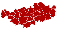
English: This map indicates (in red) the location of administrative and judicial arrondissements of Nivelles in the province of Brabant Wallon, Belgium. Both maps are the same and fill all the province of Brabant Wallon. In this case, a redirection is available at File:Judicial_Arrondissement_Nivelles_Belgium_Map.png for an easy and intuitive access to judicial arrondissement map. Colors changed based on work from w:nl:Gebruiker:LennartBolks/kaartenhoekje also in PD
Français : Cette carte indique (en rouge) la localisation de l'arrondissement administratif et judiciaire de Nivelles dans la Province de Brabant wallon, Belgique. Les deux cartes se confondent et occupent toute la province du Brabant wallon. De cette manière, une redirection est accessible à File:Judicial_Arrondissement_Nivelles_Belgium_Map.png pour un accès facile et intuitif à la carte de l'arrondissement judiciaire. Les couleurs sont basées sur le travail de w:nl:Gebruiker:LennartBolks/kaartenhoekje. |
| Sourdant | Prôpe ovraedje |
| Oteur | LennartBolks |
Licince
| Public domainPublic domainfalsefalse |
| Cette œuvre a été placée dans le domaine public par son auteur, LennartBolks. Ceci s’applique dans le monde entier. Dans certains pays, ceci peut ne pas être possible ; dans ce cas : |
Légendes
Ajoutez en une ligne la description de ce que représente ce fichier
Éléments décrits dans ce fichier
mostere
créé par français
Valeur sans élément de Wikidata
licence français
source du fichier français
type MIME français
image/png
somme de contrôle français
0e68f15a14e6e83ae83915ade98aae1c7593e3e4
taille des données français
1 692 octet
hauteur français
95 picsel
largeur français
190 picsel
Istwere do fitchî
Clitchîz so ene date ey ene eure po vey kimint ki l’ fitchî esteut adon.
| Date/Eure | Imådjete | Grandeur | Uzeu | Comintaire | |
|---|---|---|---|---|---|
| asteure | 2 avri 2005 à 09:27 | | 190 × 95 (2 Ko) | Nicnac25~commonswiki | Map of Nivelles District in province of Brabant Wallon, Belgium FR; Carte indiquant la localisation de l'arrondissement de Nivelles dans la Province de Brabant wallon. {{PD}} colors changed by me, based on work from [[w:nl:Gebruiker:LennartBolks/kaartenh |
Eployaedjes do fitchî
Li pådje shuvante eploye ci fitchî ci :
Eployaedje tot avå do fitchî
Les ôtes shuvants wikis eployèt c’ fitchî ci :
- Eployaedje so bg.wikipedia.org
- Eployaedje so br.wikipedia.org
- Eployaedje so bs.wikipedia.org
- Eployaedje so ceb.wikipedia.org
- Eployaedje so cs.wikipedia.org
- Eployaedje so de.wikipedia.org
- Eployaedje so de.wikivoyage.org
- Eployaedje so fa.wikipedia.org
- Eployaedje so fr.wikipedia.org
- Eployaedje so gl.wikipedia.org
- Eployaedje so hu.wikipedia.org
- Eployaedje so it.wikipedia.org
- Eployaedje so lb.wikipedia.org
- Eployaedje so li.wikipedia.org
- Eployaedje so lv.wikipedia.org
- Eployaedje so nl.wikipedia.org
- Eployaedje so no.wikipedia.org
- Eployaedje so ru.wikipedia.org
- Eployaedje so sv.wikipedia.org
- Eployaedje so th.wikipedia.org
- Eployaedje so vec.wikipedia.org
- Eployaedje so vi.wikipedia.org
- Eployaedje so vls.wikipedia.org
Meta-dnêyes
Ci fitchî cial a des infôrmåcions di rawete, motoit bén radjoutêyes pa l’ aparey foto limerike ou l’ sicanrece eployeye po fé l’ imådje.
Si l’ imådje a stî candjeye dispoy adon, i s’ pout ki sacwants detays ni corespondexhe pus totafwait.
| Finté d’ coûtchî | 37,95 pt/cm |
|---|---|
| Finté d’ astampé | 37,95 pt/cm |
| Date ey eure ki l’ fitchî a stî candjî | 2 d' avri 2005 a 09:29 |