File:Oslo_Areas_and_barrier_projection_2005.png
From Wikipedia, the free encyclopedia
原本檔案 (3,789 × 7,221 像素,檔案大細:268 KB ,MIME類型:image/png)
摘要
| 描述Oslo Areas and barrier projection 2005.png |
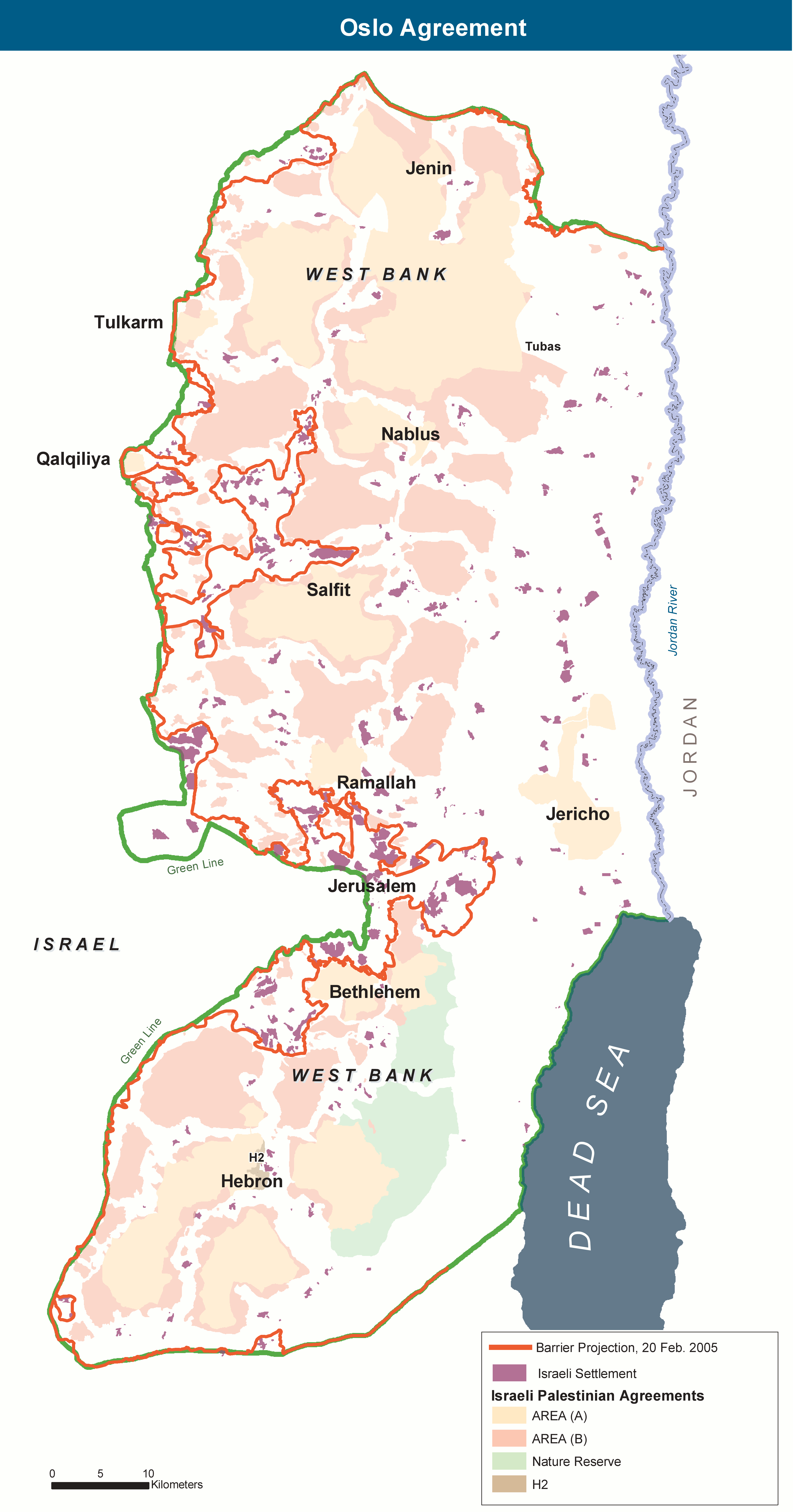
English: The Areas of the West Bank, created by the Oslo II Accord of 1995, and the Israeli Wall project as of 20 February 2005. |
| 日期 | |
| 來源 | 自己作品. Adaptation of http://www.ochaopt.org/documents/WB_OsloGov&Barrier_July05.pdf on OCHAoPt Map Centre. |
| 作者 | Wickey-nl |
協議
| Public domainPublic domainfalsefalse |
| This image is a map derived from a United Nations map.
Unless stated otherwise, UN maps are to be considered in the public domain. This applies worldwide. UN maps are, in principle, open source material and you can use them in your work or for making your own map. UN requests however that you delete the UN name, logo and reference number upon any modification to the map. Content of your map will be your responsibility. You can state in your publication, if you wish, something like: based on UN map … (map name, map number, revision number and date). See: Geospatial Information Section. And: Geospatial, location data for a better world. |
 |
Captions
Items portrayed in this file
圖中顯示嘅係
7 11 2013
image/png
檔案歷史
撳個日期/時間去睇響嗰個時間出現過嘅檔案。
| 日期/時間 | 縮圖 | 尺寸 | 用戶 | 註解 | |
|---|---|---|---|---|---|
| 現時 | 2013年11月7號 (四) 12:01 | | 3,789 × 7,221(268 KB) | Wickey-nl | User created page with UploadWizard |
檔案用途
以下嘅1版用到呢個檔:
全域檔案使用情況
下面嘅維基都用緊呢個檔案:
- ar.wikipedia.org嘅使用情況
- arz.wikipedia.org嘅使用情況
- ca.wikipedia.org嘅使用情況
- de.wikipedia.org嘅使用情況
- en.wikipedia.org嘅使用情況
- es.wikipedia.org嘅使用情況
- eu.wikipedia.org嘅使用情況
- fr.wikipedia.org嘅使用情況
- he.wikipedia.org嘅使用情況
- it.wikipedia.org嘅使用情況
- ko.wikipedia.org嘅使用情況
- pl.wikipedia.org嘅使用情況
- sh.wikipedia.org嘅使用情況
- sv.wikipedia.org嘅使用情況
- www.wikidata.org嘅使用情況
Metadata
呢個檔案有額外嘅資料。佢應該係數碼相機或者掃描器整出來嘅。如果佢整咗之後畀人改過,裏面嘅資料未必同改過之後相符。
| 橫解像度 | 236.22 dpc |
|---|---|
| 直解像度 | 236.22 dpc |
| 檔案更動日期時間 | 2013年11月7號 (四) 11:44 |