File:PIA01153.jpg
維基百科,自由的 encyclopedia
本预览的尺寸:798 × 133像素。 其他分辨率:320 × 53像素 | 640 × 107像素 | 4,201 × 701像素。
原始文件 (4,201 × 701像素,文件大小:817 KB,MIME类型:image/jpeg)
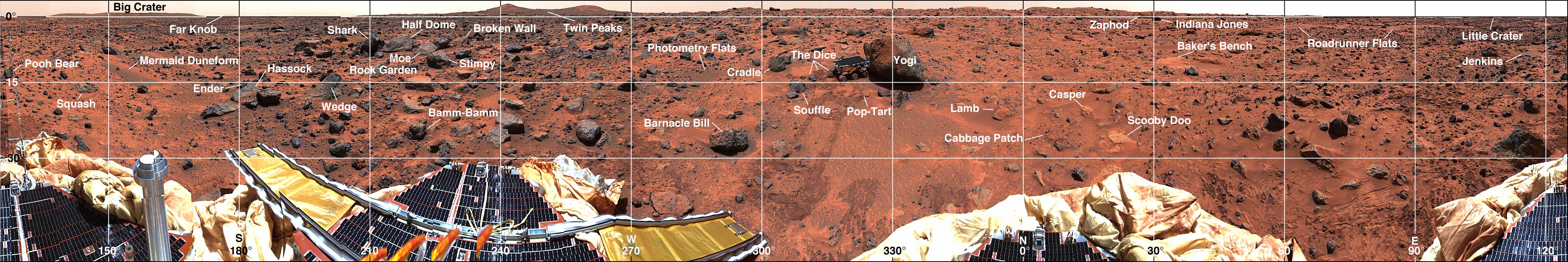
| 描述PIA01153.jpg | Mars-local-level (LL frame) coordinate map of rocks counted at the Mars Pathfinder landing site. Positions, apparent diameters (D), and heights (H) were measured to the nearest centimeter in the Mars map virtual reality environment constructed from the "Monster Pan" |
| 来源 | https://photojournal.jpl.nasa.gov/catalog/PIA01153 |
| 作者 | NASA |
| 授权 (二次使用本文件) |
Original work of NASA - public domain |
| 其他版本 | http://photojournal.jpl.nasa.gov/catalog/PIA01153 |
| Public domainPublic domainfalsefalse |
| 本文件完全由NASA创作,在美国属于公有领域。根据NASA的版权方针,NASA的材料除非另有声明否则不受版权保护。(参见Template:PD-USGov/zh、NASA版权方针页面或JPL图片使用方针。) | ||
 |
警告:
|
说明
添加一行文字以描述该文件所表现的内容
此文件中描述的项目
描繪內容
image/jpeg
文件历史
点击某个日期/时间查看对应时刻的文件。
| 日期/时间 | 缩略图 | 大小 | 用户 | 备注 | |
|---|---|---|---|---|---|
| 当前 | 2007年5月27日 (日) 18:33 | 4,201 × 701(817 KB) | Clh288~commonswiki | {{Information |Description= Mars-local-level (LL frame) coordinate map of rocks counted at the Mars Pathfinder landing site. Positions, apparent diameters (D), and heights (H) were measured to the nearest centimeter in the Mars map virtual reality envi |
文件用途
以下页面使用本文件:
全域文件用途
以下其他wiki使用此文件:
- be.wikipedia.org上的用途
- bg.wikipedia.org上的用途
- en.wikipedia.org上的用途
- ru.wikipedia.org上的用途
- uk.wikipedia.org上的用途
元数据
此文件中包含有扩展的信息。这些信息可能是由数码相机或扫描仪在创建或数字化过程中所添加。
如果此文件的源文件已经被修改,一些信息在修改后的文件中将不能完全反映出来。
| _error | 0 |
|---|