File:US_SlaveFree1789.gif
維基百科,自由的 encyclopedia
此为最大尺寸。
US_SlaveFree1789.gif (774 × 468像素,文件大小:20 KB,MIME类型:image/gif)
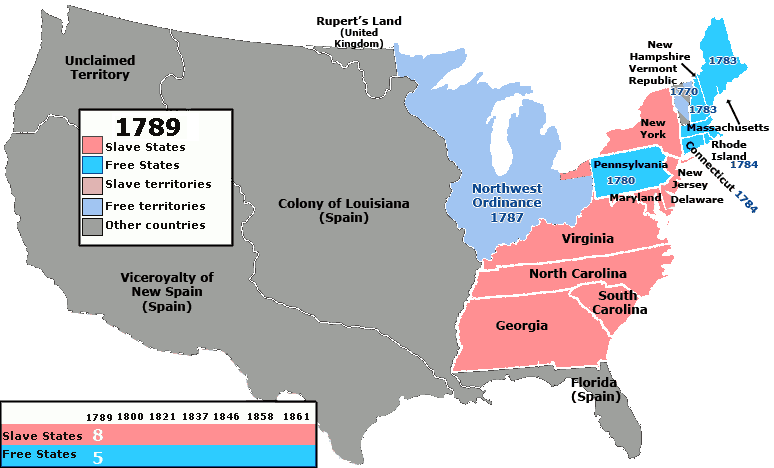
| 描述US SlaveFree1789.gif | Map of the states and territories of the United States as it was from March 1789 to August 1789 showing which areas of the United States did and did not allow slavery. Territories and states which had not specifically banned slavery are colored red/pink. |
| 日期 | (UTC) |
| 来源 | |
| 作者 |
|
我,本作品著作权人,特此采用以下许可协议发表本作品:
| 本文件采用知识共享署名-相同方式共享 3.0 未本地化版本许可协议授权。 | ||
| ||
| 本许可协议标签作为GFDL许可协议更新的组成部分被添加至本文件。http://creativecommons.org/licenses/by-sa/3.0/CC BY-SA 3.0Creative Commons Attribution-Share Alike 3.0truetrue |

|
已授权您依据自由软件基金会发行的无固定段落及封面封底文字(Invariant Sections, Front-Cover Texts, and Back-Cover Texts)的GNU自由文件许可协议1.2版或任意后续版本的条款,复制、传播和/或修改本文件。该协议的副本请见“GNU Free Documentation License”。http://www.gnu.org/copyleft/fdl.htmlGFDLGNU Free Documentation Licensetruetrue |
您可以选择您需要的许可协议。
原始上传日志
This image is a derivative work of the following images:
- File:United_States_1789-03-1789-08.png licensed with Cc-by-2.5, Cc-by-sa-3.0-migrated, GFDL
- 2007-08-14T10:58:05Z Golbez 1000x677 (99534 Bytes)
Uploaded with derivativeFX
说明
添加一行文字以描述该文件所表现的内容
此文件中描述的项目
描繪內容
14 10 2010
文件历史
点击某个日期/时间查看对应时刻的文件。
| 日期/时间 | 缩略图 | 大小 | 用户 | 备注 | |
|---|---|---|---|---|---|
| 当前 | 2010年10月14日 (四) 20:59 | | 774 × 468(20 KB) | Kenmayer | {{Information |Description=Map of the states and territories of the United States as it was from March 1789 to August 1789 showing which areas of the United States did and did not allow slavery. Territories and states which had not specifically banned sla |
文件用途
没有页面链接到本图像。
全域文件用途
以下其他wiki使用此文件:
- en.wikipedia.org上的用途
- es.wikipedia.org上的用途
- fa.wikipedia.org上的用途
- it.wikipedia.org上的用途
- ro.wikipedia.org上的用途
- ru.wikipedia.org上的用途
- simple.wikipedia.org上的用途