Restr:NS_administrative_Gliederung_1944.png
From Wikipedia, the free encyclopedia
Restr orin (8 000 × 6 094 piksel, ment ar restr : 4,14 Mio, seurt MIME : image/png)
![]()
| Tennet eo ar restr-mañ eus Wikimedia Commons ha gallout a ra bezañ implijet evit raktresoù all. Diskouezet eo deskrivadur he fajenn zeskrivañ amañ dindan. |

|
This locator map image could be re-created using vector graphics as an SVG file. This has several advantages; see Commons:Media for cleanup for more information. If an SVG form of this image is available, please upload it and afterwards replace this template with
{{vector version available|new image name}}.
It is recommended to name the SVG file “NS administrative Gliederung 1944.svg”—then the template Vector version available (or Vva) does not need the new image name parameter. |
Diverradur
| DeskrivadurNS administrative Gliederung 1944.png |
Беларуская (тарашкевіца): Мапа адміністрацыйна-тэрытарыяльнага падзелу Вялікага нямецкага райху паводле НСДАП (1944).
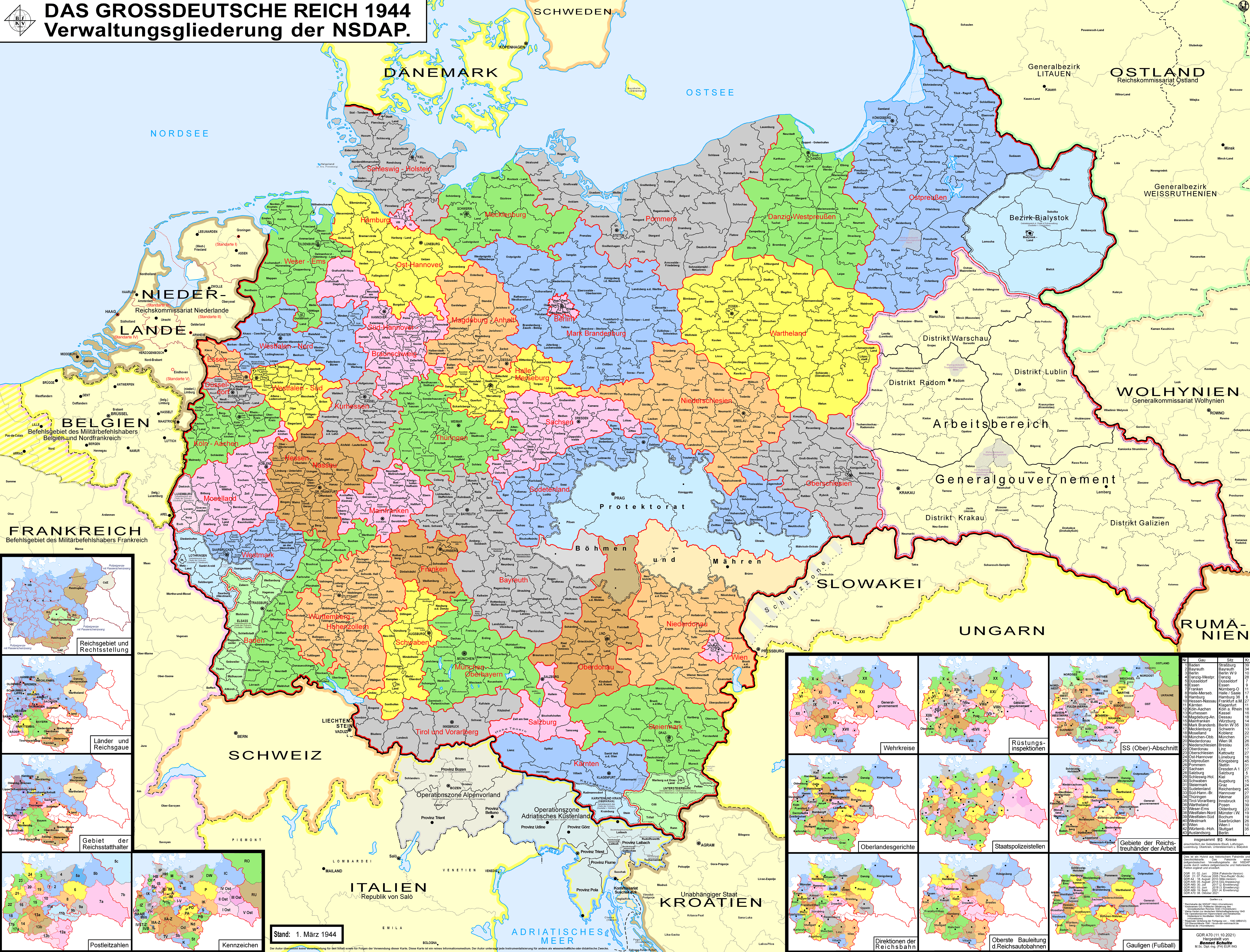
Deutsch: Karte der Verwaltungsgliederung des Großdeutschen Reiches durch die NSDAP 1944. Sie zeigt die Kreise, Gaue und Reichsgaue der NSDAP. Zudem die Länder, die Gebiete der Reichsstatthalter und die Rechtsstellung der Reichsteile. Zusätzlich Postleitzahlen, Kennzeichen, Wehrkreise, Oberlandesgerichte, Staatspolizeistellen, Direktionen der Reichsbahn, Oberste Bauleitung der Reichsautobahnen und Arbeitsamtsgebiete 1944.
English: Map of the administrative division of the Greater German Reich (»Großdeutsches Reich«/»Großdeutschland«/"Greater German Empire"/"Greater Germany") by the NSDAP (Nazi Party) 1944, showing Kreise, Gaue and Reichsgaue. In addition, the states, the territories of the Reichsstatthalter and the legal status of Reich territories. Additionally postal codes, license plates, military districts, higher regional courts, State Police offices, railway directorates, Supreme construction management of the highways and work coordination areas 1944.
Polski: Mapa Wielkiej Rzeszy Niemieckiej (1944)
Русский: Административно-территориальное деление Третьего Рейха - Великой Германии (1944)
Українська: Адміністративно-територіальний поділ Третього Рейху - Великої Німеччини (1944) |
||
| Deiziad | |||
| Mammenn | Labour an-unan | ||
| Aozer | Bennet Schulte | ||
| Aotre (Adimplij ar restr-mañ) |
Ar restr-mañ a zo dindan an aotre-implijout Creative Commons Deroadenn-Share Alike 3.0 Alamagn.
 |
||
| Stummoù all |
|


| Annotations InfoField | This image is annotated: View the annotations at Commons |
Distrikt Galizien
Partei-Gau/Reichsgau Wartheland
Distrikt Warschau
Partei-Gau Ostpreußen
Distrikt Lublin
Distrikt Radom
Distirkt Krakau
Partei-Gau Oberschlesien
Partei-Gau Niederschlesien
Partei-Gau/Reichsgau Sudetenland
Captions
Items portrayed in this file
diskouez a ra
some value
18 Eos 2010
source of file saozneg
original creation by uploader saozneg
image/png
Istor ar restr
Klikañ war un deiziad/eur da welet ar restr evel ma oa da neuze.
| Deiziad/Eur | Munud | Mentoù | Implijer | Notenn | |
|---|---|---|---|---|---|
| red | 12 Her 2021 da 03:32 | | 8 000 × 6 094 (4,14 Mio) | Exec | resolution reduzed |
| 12 Her 2021 da 03:31 |  | 17 392 × 13 248 (4,99 Mio) | Exec | -render modus of previous version fixed | |
| 11 Her 2021 da 13:09 |  | 8 000 × 6 094 (7,98 Mio) | Exec | - Lublin-Galicia-Adjustment implemented, Galicia internal boundaries redone, modifications at Desitrikt Bialystok | |
| 6 Her 2021 da 10:36 |  | 8 000 × 6 094 (22,08 Mio) | Kamilhrub | Corrected name Hrubieszow and southern borders of Bilgoraj, Hrubieszow and Zamosc districts, which didn't change after 1941 (source: Amtliches Gemeinde- und Dorfverzeichnis für das Generalgouvernement auf Grund der Summarischen Bevölkerungsbestandsaufnahme am 1. März 1943) | |
| 19 Gwe 2021 da 22:27 |  | 8 000 × 6 094 (19,36 Mio) | Exec | content exansion on multiple aspects | |
| 19 Gwe 2021 da 22:15 |  | 8 000 × 6 094 (8,37 Mio) | Exec | inhaltliche Erweiterung verschiedenster Art | |
| 21 C'hwe 2021 da 00:33 |  | 8 000 × 6 094 (22,22 Mio) | Exec | - additional small map of Wehrinspektionen; minor corrections | |
| 12 Ebr 2019 da 14:57 |  | 8 000 × 6 094 (3,46 Mio) | FDRMRZUSA | Lower resolution but better display: no more display problems and same image quality. Previous file too big: bigger dimensions not necessary. Reduced size: compressed and optimized. No other changes. | |
| 5 Mez 2018 da 21:54 |  | 17 392 × 13 248 (11,47 Mio) | Exec | - another color correction | |
| 5 Mez 2018 da 21:33 |  | 17 366 × 13 226 (11,46 Mio) | Exec | Color Error Correction |
Implij ar restr
Implijout a ra an 3 pajenn da heul ar restr-mañ :
Implij hollek ar restr
Ober a ra ar wikioù da-heul gant ar restr-mañ :
- Implij war af.wikipedia.org
- Implij war an.wikipedia.org
- Implij war ar.wikipedia.org
- Implij war ast.wikipedia.org
- Implij war azb.wikipedia.org
- Implij war ba.wikipedia.org
- Implij war be-tarask.wikipedia.org
- Implij war be.wikipedia.org
- Implij war bg.wikipedia.org
- Implij war bn.wikipedia.org
- Implij war bs.wikipedia.org
- Implij war ca.wikipedia.org
- Protectorat de Bohèmia i Moràvia
- Potències de l'Eix
- Partit Nacionalsocialista Alemany dels Treballadors
- Zona d'Operacions dels Prealps
- Gauleiter
- Gran Alemanya
- Govern General
- Divisions administratives de l'Alemanya nazi
- Zona d'Operacions del Litoral Adriàtic
- Viquipèdia:Estat Lliure de Prússia
- Usuari:Casablanca~cawiki/Estat Lliure de Prússia
- Reichsgau
- Gau de Magdeburg-Anhalt
- Gau de Halle-Merseburg
- Gau de Baden
- Gau de Württemberg-Hohenzollern
- Gau de Bayreuth
- Gau de Francònia
- Gau de Main-Francònia
- Gau de Múnic-Alta Baviera
- Gau de Suàbia
- Gau de Hannover del Sud-Brunsvic
- Gau de Hannover Oriental
- Gau de Turíngia
- Gau de Mecklenburg
- Gau de Weser-Ems
- Gau de Westfàlia del Nord
- Plantilla:Divisions administratives de l'Alemanya Nazi
Gwelet muioc'h eus implij hollek ar restr-mañ.
Metaroadennoù
Titouroù ouzhpenn zo er restr-mañ; bet lakaet moarvat gant ar c'hamera niverel pe ar skanner implijet evit he niverelaat. Mard eo bet cheñchet ar skeudenn e-keñver he stad orin marteze ne vo ket kenkoulz munudoù zo e-keñver ar skeudenn kemmet.
| Meziant bet implijet |
|
|---|