
Marpingen
Municipality in Saarland, Germany / From Wikipedia, the free encyclopedia
Dear Wikiwand AI, let's keep it short by simply answering these key questions:
Can you list the top facts and stats about Marpingen?
Summarize this article for a 10 year old
SHOW ALL QUESTIONS
Marpingen is a municipality in the district of Sankt Wendel, in Saarland, Germany. It is situated approximately 8 km west of Sankt Wendel, and 25 km north of Saarbrücken.
Quick Facts Country, State ...
Marpingen | |
|---|---|
 | |
 Coat of arms | |
Location of Marpingen within Sankt Wendel district 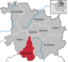 | |
 Marpingen  Marpingen | |
| Coordinates: 49°27′N 7°3′E | |
| Country | Germany |
| State | Saarland |
| District | Sankt Wendel |
| Subdivisions | 4 |
| Government | |
| • Mayor (2016–26) | Volker Weber[1] (SPD) |
| Area | |
| • Total | 39.68 km2 (15.32 sq mi) |
| Elevation | 301 m (988 ft) |
| Population (2022-12-31)[2] | |
| • Total | 9,935 |
| • Density | 250/km2 (650/sq mi) |
| Time zone | UTC+01:00 (CET) |
| • Summer (DST) | UTC+02:00 (CEST) |
| Postal codes | 66646 |
| Dialling codes | 06827, 06853 |
| Vehicle registration | WND |
| Website | www.marpingen.de |
Close
The municipality contains the urban areas Marpingen, Urexweiler, Alsweiler und Berschweiler, which have the status of Ortschaft, and Rheinstraße, which is in the administrative area of Marpingen, and Habenichts, which is in the administrative area of Urexweiler.