קובץ:NS_administrative_Gliederung_1944.png
ויקיפדיה האנציקלופדיה encyclopedia
לקובץ המקורי (8,000 × 6,094 פיקסלים, גודל הקובץ: 4.14 מ"ב, סוג MIME: image/png)
| זהו קובץ שמקורו במיזם ויקישיתוף. תיאורו בדף תיאור הקובץ המקורי (בעברית) מוצג למטה. |

|
יש ליצור מחדש את התמונה locator map הזו באמצעות גרפיקה וקטורית כדוגמת קובץ SVG. לפעולה זו מספר יתרונות, כפי שניתן לקרוא (באנגלית) בדף Commons:Media for cleanup. אם ברשותכם קובץ SVG, אנא העלו אותו. לאחר מכן, החליפו תבנית זו בתבנית
{{vector version available|שם הקובץ.svg}} |
תקציר
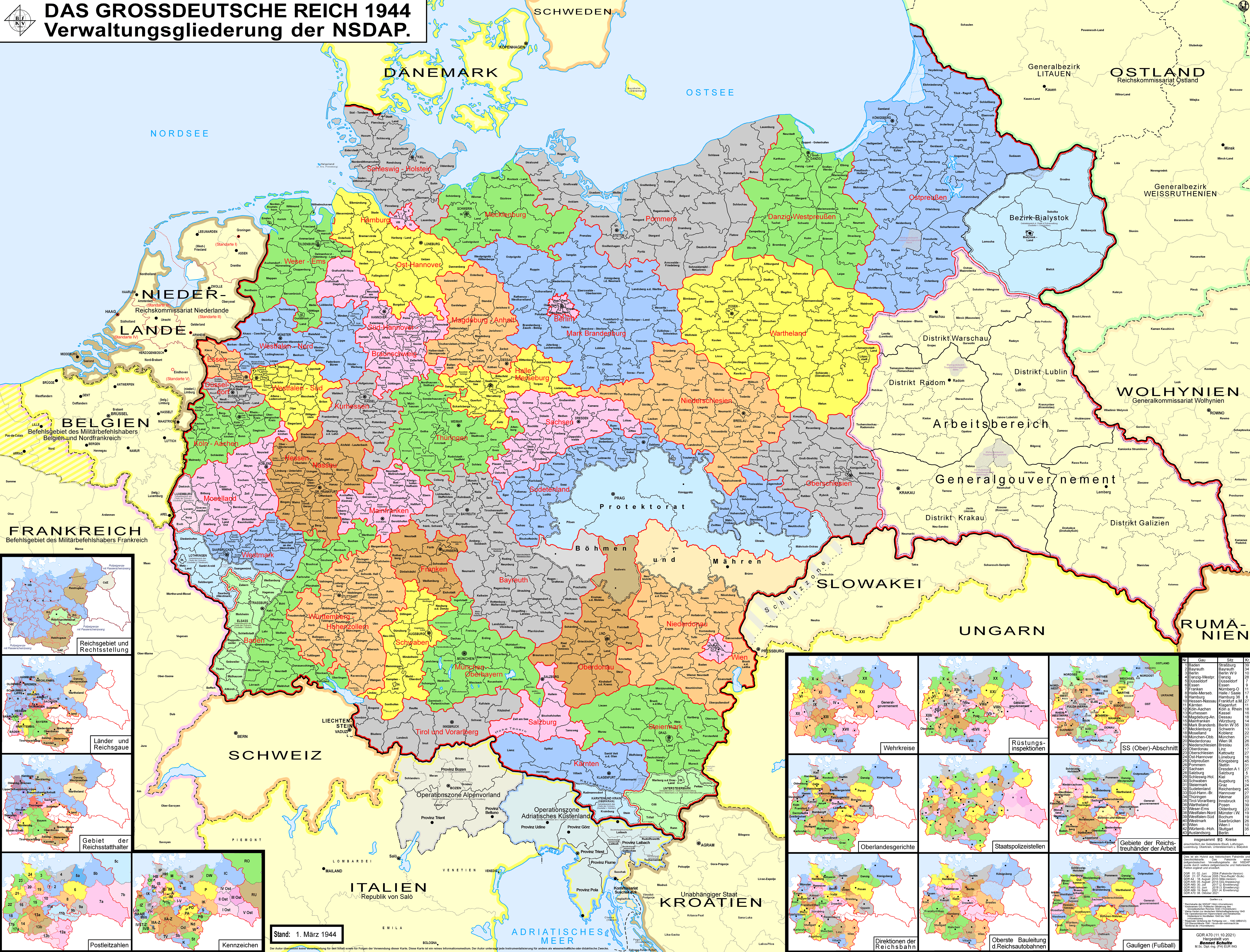
| תיאורNS administrative Gliederung 1944.png |
Беларуская (тарашкевіца): Мапа адміністрацыйна-тэрытарыяльнага падзелу Вялікага нямецкага райху паводле НСДАП (1944).
Deutsch: Karte der Verwaltungsgliederung des Großdeutschen Reiches durch die NSDAP 1944. Sie zeigt die Kreise, Gaue und Reichsgaue der NSDAP. Zudem die Länder, die Gebiete der Reichsstatthalter und die Rechtsstellung der Reichsteile. Zusätzlich Postleitzahlen, Kennzeichen, Wehrkreise, Oberlandesgerichte, Staatspolizeistellen, Direktionen der Reichsbahn, Oberste Bauleitung der Reichsautobahnen und Arbeitsamtsgebiete 1944.
English: Map of the administrative division of the Greater German Reich (»Großdeutsches Reich«/»Großdeutschland«/"Greater German Empire"/"Greater Germany") by the NSDAP (Nazi Party) 1944, showing Kreise, Gaue and Reichsgaue. In addition, the states, the territories of the Reichsstatthalter and the legal status of Reich territories. Additionally postal codes, license plates, military districts, higher regional courts, State Police offices, railway directorates, Supreme construction management of the highways and work coordination areas 1944.
Polski: Mapa Wielkiej Rzeszy Niemieckiej (1944)
Русский: Административно-территориальное деление Третьего Рейха - Великой Германии (1944)
Українська: Адміністративно-територіальний поділ Третього Рейху - Великої Німеччини (1944) |
||
| תאריך יצירה | |||
| מקור | נוצר על־ידי מעלה היצירה | ||
| יוצר | Bennet Schulte | ||
| אישורים והיתרים (שימוש חוזר בקובץ זה) |
הקובץ הזה מתפרסם לפי תנאי רישיון קריאייטיב קומונז ייחוס-שיתוף זהה 3.0 גרמניה.
 |
||
| גרסאות אחרות |
|


| Annotations InfoField | This image is annotated: View the annotations at Commons |
Distrikt Galizien
Partei-Gau/Reichsgau Wartheland
Distrikt Warschau
Partei-Gau Ostpreußen
Distrikt Lublin
Distrikt Radom
Distirkt Krakau
Partei-Gau Oberschlesien
Partei-Gau Niederschlesien
Partei-Gau/Reichsgau Sudetenland
כיתובים
פריטים שמוצגים בקובץ הזה
מוצג
ערך כלשהו ללא פריט ויקינתונים
18 באוגוסט 2010
image/png
היסטוריית הקובץ
ניתן ללחוץ על תאריך/שעה כדי לראות את הקובץ כפי שנראה באותו זמן.
| תאריך/שעה | תמונה ממוזערת | ממדים | משתמש | הערה | |
|---|---|---|---|---|---|
| נוכחית | 06:32, 12 באוקטובר 2021 | | 6,094 × 8,000 (4.14 מ"ב) | Exec | resolution reduzed |
| 06:31, 12 באוקטובר 2021 |  | 13,248 × 17,392 (4.99 מ"ב) | Exec | -render modus of previous version fixed | |
| 16:09, 11 באוקטובר 2021 |  | 6,094 × 8,000 (7.98 מ"ב) | Exec | - Lublin-Galicia-Adjustment implemented, Galicia internal boundaries redone, modifications at Desitrikt Bialystok | |
| 13:36, 6 באוקטובר 2021 |  | 6,094 × 8,000 (22.08 מ"ב) | Kamilhrub | Corrected name Hrubieszow and southern borders of Bilgoraj, Hrubieszow and Zamosc districts, which didn't change after 1941 (source: Amtliches Gemeinde- und Dorfverzeichnis für das Generalgouvernement auf Grund der Summarischen Bevölkerungsbestandsaufnahme am 1. März 1943) | |
| 01:27, 20 בספטמבר 2021 |  | 6,094 × 8,000 (19.36 מ"ב) | Exec | content exansion on multiple aspects | |
| 01:15, 20 בספטמבר 2021 |  | 6,094 × 8,000 (8.37 מ"ב) | Exec | inhaltliche Erweiterung verschiedenster Art | |
| 03:33, 21 בפברואר 2021 |  | 6,094 × 8,000 (22.22 מ"ב) | Exec | - additional small map of Wehrinspektionen; minor corrections | |
| 17:57, 12 באפריל 2019 |  | 6,094 × 8,000 (3.46 מ"ב) | FDRMRZUSA | Lower resolution but better display: no more display problems and same image quality. Previous file too big: bigger dimensions not necessary. Reduced size: compressed and optimized. No other changes. | |
| 00:54, 6 ביוני 2018 |  | 13,248 × 17,392 (11.47 מ"ב) | Exec | - another color correction | |
| 00:33, 6 ביוני 2018 |  | 13,226 × 17,366 (11.46 מ"ב) | Exec | Color Error Correction |
שימוש בקובץ
הדפים הבאים משתמשים בקובץ הזה:
שימוש גלובלי בקובץ
אתרי הוויקי השונים הבאים משתמשים בקובץ זה:
- שימוש באתר af.wikipedia.org
- שימוש באתר an.wikipedia.org
- שימוש באתר ar.wikipedia.org
- שימוש באתר ast.wikipedia.org
- שימוש באתר azb.wikipedia.org
- שימוש באתר ba.wikipedia.org
- שימוש באתר be-tarask.wikipedia.org
- שימוש באתר be.wikipedia.org
- שימוש באתר bg.wikipedia.org
- שימוש באתר bn.wikipedia.org
- שימוש באתר br.wikipedia.org
- שימוש באתר bs.wikipedia.org
- שימוש באתר ca.wikipedia.org
- Protectorat de Bohèmia i Moràvia
- Potències de l'Eix
- Partit Nacionalsocialista Alemany dels Treballadors
- Zona d'Operacions dels Prealps
- Gauleiter
- Gran Alemanya
- Govern General
- Divisions administratives de l'Alemanya nazi
- Zona d'Operacions del Litoral Adriàtic
- Viquipèdia:Estat Lliure de Prússia
- Usuari:Casablanca~cawiki/Estat Lliure de Prússia
- Reichsgau
- Gau de Magdeburg-Anhalt
- Gau de Halle-Merseburg
- Gau de Baden
- Gau de Württemberg-Hohenzollern
- Gau de Bayreuth
- Gau de Francònia
- Gau de Main-Francònia
- Gau de Múnic-Alta Baviera
- Gau de Suàbia
- Gau de Hannover del Sud-Brunsvic
- Gau de Hannover Oriental
- Gau de Turíngia
- Gau de Mecklenburg
מטא־נתונים
קובץ זה מכיל מידע נוסף, שכנראה הגיע ממצלמה דיגיטלית או מסורק שבהם הקובץ נוצר או עבר דיגיטציה.
אם הקובץ שונה ממצבו הראשוני, כמה מהנתונים להלן עלולים שלא לשקף באופן מלא את הקובץ הנוכחי.
| תוכנה בשימוש |
|
|---|