File:Bia-map-indian-reservations-usa.png
Da Wikipedia, l'enciclopedia encyclopedia
Dimensioni di questa anteprima: 800 × 563 pixel. Altre risoluzioni: 320 × 225 pixel | 640 × 451 pixel | 1 024 × 721 pixel | 1 280 × 901 pixel | 2 560 × 1 803 pixel | 3 124 × 2 200 pixel.
File originale (3 124 × 2 200 pixel, dimensione del file: 457 KB, tipo MIME: image/png)
| Questo file e la sua pagina di descrizione (discussione · modifica) si trovano su Wikimedia Commons (?) |

|
Questa immagine (categorizzazione automatica: ethnographic map) o tutte le immagini in questa categoria o galleria dovrebbero essere ricreate usando grafica vettoriale come file SVG. Questo offre diversi vantaggi: vedi Commons:Media for cleanup per maggiori informazioni. Se è disponibile una versione in formato SVG di questa immagine, per favore caricala. Dopo aver caricato un file SVG, sostituisci questo avviso con il template {{Vector version available|nome_immagine.svg}}.
|

|
Questo file è stato rimpiazzato da File:Indian reservations in the Continental United States.png. Si raccomanda di usare l'altro file. Per favore ricorda che la cancellazione di immagini rimpiazzate è soggetta a consenso. Motivo per usare l'altro file: "Updated to include newly-established reservations"
|

|
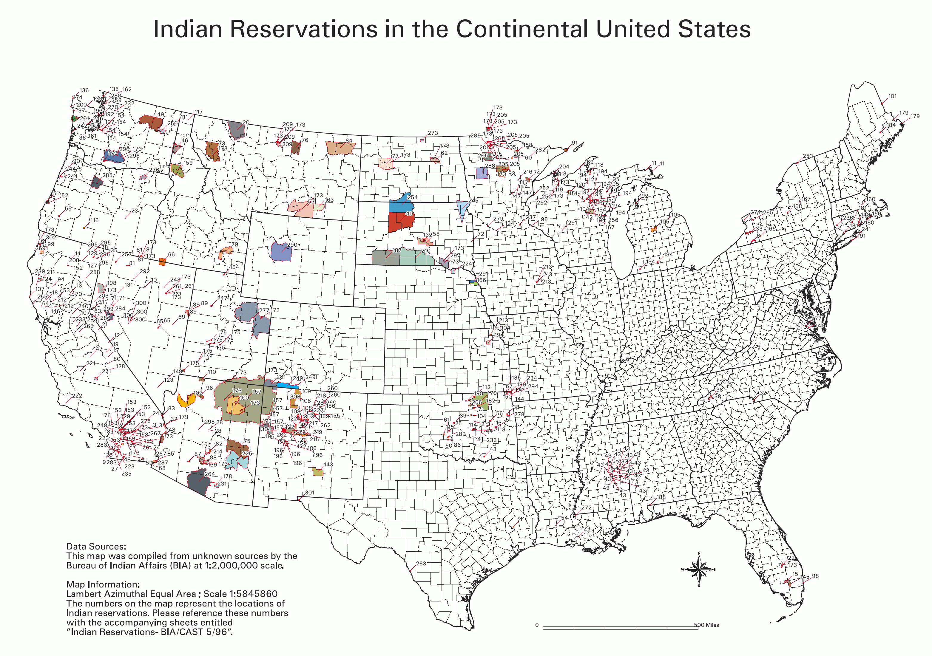
Source
- National Park Service; see also: Bureau of Indian Affairs
Key
- 0 No Data
- Absentee Shawnee
- Acoma
- Agua Caliente
- Alabama-Coushatta
- Alabama-Quassarte Creeks
- Allegany
- Apache
- Bad River
- Barona Ranch
- Battle Mountain
- Bay Mills
- Benton Paiute
- Berry Creek
- Big Bend
- Big Cypress
- Big Lagoon
- Big Pine
- Big Valley
- Bishop
- Blackfeet
- Bridgeport
- Brighton
- Burns Paiute Colony
- Cabezon
- Caddo
- Cahuilla
- Campo
- Camp Verde
- Canoncito
- Capitan Grande
- Carson
- Catawba
- Cattaraugus
- Cayuga
- Cedarville
- Chehalis
- Chemehuevi
- Cherokee
- Cheyenne-Arapahoe
- Cheyenne River
- Chickasaw
- Chitimacha
- Choctaw
- Citizen Band Of Potawatomi
- Cochiti
- Coeur D'alene
- Cold Springs
- Colorado River
- Colville
- Comanche
- Coos, Lower Umpqua & Siuslaw
- Coquille
- Cortina
- Coushatta
- Cow Creek
- Creek
- Crow
- Crow Creek
- Cuyapaipe
- Deer Creek
- Delaware
- Devils Lake
- Dresslerville Colony
- Dry Creek
- Duckwater
- Duck Valley
- Eastern Shawnee
- East Cocopah
- Ely Colony
- Enterprise
- Fallon/Stillwater
- Flandreau Indian School
- Flathead
- Fond Du Lac
- Fort Apache
- Fort Belknap
- Fort Berthold
- Fort Bidwell
- Fort Hall
- Fort Independence
- Fort Mcdermitt
- Fort Mcdowell
- Fort Mohave
- Fort Peck
- Fort Yuma
- Ft. Sill Apache
- Gila Bend
- Gila River
- Goshute
- Grande Ronde
- Grand Portage
- Grand Traverse
- Greater Leech Lake
- Grindstone
- Hannahville
- Havasupai
- Hoh
- Hollywood
- Hoopa Valley
- Hopi
- Houlton Maliseets
- Hualapai
- Inaja
- Iowa
- Isabella
- Isleta
- Jackson
- Jemez
- Jicarilla
- Kaibab
- Kalispel
- Kaw
- Kialegee Creek
- Kickapoo
- Kiowa
- Klamath
- Kootenai
- L'anse
- Lac Courte Oreilles
- Lac Du Flambeau
- Lac Vieux Desert
- Laguna
- Las Vegas
- Laytonville
- La Jolla
- La Posta
- Likely
- Lone Pine
- Lookout
- Los Coyotes
- Lovelock Colony
- Lower Brule
- Lower Elwah
- Lower Sioux
- Lummi
- Makah
- Manchester
- Manzanita
- Maricopa
- Mashantucket Pequot
- Mattaponi
- Menominee
- Mescalero
- Miami
- Miccosukee
- Middletown
- Mille Lacs
- Mission
- Moapa
- Modoc
- Mole Lake
- Montgomery Creek
- Morongo
- Muckleshoot
- Nambe
- Narragansett
- Navajo
- Nett Lake
- Nez Perce
- Nipmuc-Hassanamisco
- Nisqually
- Nooksack
- Northern Cheyenne
- Northwestern Shoshone
- Oil Springs
- Omaha
- Oneida
- Onondaga
- Ontonagon
- Osage
- Otoe-Missouri
- Ottawa
- Out
- Ozette
- Paiute
- Pala
- Pamunkey
- Pascua Yaqui
- Passamaquoddy
- Paucatauk Pequot
- Paugusett
- Pawnee
- Pechanga
- Penobscot
- Peoria
- Picuris
- Pine Ridge
- Poarch Creek
- Pojoaque
- Ponca
- Poosepatuck
- Port Gamble
- Port Madison
- Potawatomi
- Prairie Isle
- Puertocito
- Puyallup
- Pyramid Lake
- Quapaw
- Quillayute
- Quinault
- Ramah
- Ramona
- Red Cliff
- Red Lake
- Reno-Sparks
- Rincon
- Roaring Creek
- Rocky Boys
- Rosebud
- Round Valley
- Rumsey
- Sac And Fox
- Salt River
- Sandia
- Sandy Lake
- Santa Ana
- Santa Clara
- Santa Domingo
- Santa Rosa
- Santa Rosa (North)
- Santa Ynez
- Santa Ysabel
- Santee
- San Carlos
- San Felipe
- San Ildefonso
- San Juan
- San Manual
- San Pasqual
- San Xavier
- Sauk Suiattle
- Seminole
- Seneca-Cayuga
- Sequan
- Shagticoke
- Shakopee
- Sheep Ranch
- Sherwood Valley
- Shingle Spring
- Shinnecock
- Shoalwater
- Shoshone
- Siletz
- Sisseton
- Skokomish
- Skull Valley
- Soboba
- Southern Ute
- Spokane
- Squaxon Island
- St. Croix
- St. Regis
- Standing Rock
- Stewarts Point
- Stockbridge Munsee
- Summit Lake
- Susanville
- Swinomish
- Taos
- Te-Moak
- Tesuque
- Texas Kickapoo
- Tohono O'odham
- Tonawanda
- Tonikawa
- Torres Martinez
- Toulumne
- Trindad
- Tulalip
- Tule River
- Tunica-Biloxi
- Turtle Mountains
- Tuscarora
- Twentynine Palms
- Umatilla
- Uintah And Ouray
- United Keetoowah Band Of Cherokee
- Upper Sioux
- Upper Skagit
- Ute Mountain
- Vermilion Lake
- Viejas
- Walker River
- Warm Springs
- Washoe
- West Cocopah
- White Earth
- Wichita
- Wind River
- Winnebago
- Winnemucca
- Woodford Indian Community
- Wyandotte
- Xl Ranch
- Yakama
- Yankton
- Yavapai
- Yerington
- Yomba
- Ysleta Del Sur
- Yurok
- Zia
- Zuni
Info contained in image
Data Sources: This map was compiled from unknown sources by the Bureau of Indian Affairs (BIA) at 1:2,000,000 scale.
Map Information: Lambert Azimuthal Equal Area; Scale 1:5845860 The numbers on the map represent the locations of Indian reservations. Please reference these numbers with the accompanying sheets entitled Indian Reservations - BIA/CAST 5/96
Dettagli
English: BIA map of Indian Reservations in the Continental United States. An index to the reservations of the map can be found on the National NAGPRA site, http://www.cr.nps.gov/nagpra/. That key is currently at http://www.nps.gov/history/nagpra/documents/ResMapIndex.htm.
Licenza
| Public domainPublic domainfalsefalse |
| This image or media file contains material based on a work of a National Park Service employee, created as part of that person's official duties. As a work of the U.S. federal government, such work is in the public domain in the United States. See the NPS website and NPS copyright policy for more information. |
derivative works
Opere derivate da questo file:
Didascalie
Aggiungi una brevissima spiegazione di ciò che questo file rappresenta
Карта индейских резерваций в США
Elementi ritratti in questo file
raffigura
image/png
4bbf9ff352889a4d233ac05a68df95b1fe97c30f
467 634 byte
2 200 pixel
3 124 pixel
Cronologia del file
Fare clic su un gruppo data/ora per vedere il file come si presentava nel momento indicato.
| Data/Ora | Miniatura | Dimensioni | Utente | Commento | |
|---|---|---|---|---|---|
| attuale | 03:06, 1 feb 2006 | | 3 124 × 2 200 (457 KB) | Wille Raab~commonswiki | BIA map of Indian Reservations in the Continental United States. An index to the reservations of the map can be found on the National NAGPRA site, http://www.cr.nps.gov/nagpra/. |
Pagine che usano questo file
Le seguenti 3 pagine usano questo file:
Utilizzo globale del file
Anche i seguenti wiki usano questo file:
- Usato nelle seguenti pagine di af.wikipedia.org:
- Usato nelle seguenti pagine di ast.wikipedia.org:
- Usato nelle seguenti pagine di bar.wikipedia.org:
- Usato nelle seguenti pagine di ba.wikipedia.org:
- Usato nelle seguenti pagine di be.wikipedia.org:
- Usato nelle seguenti pagine di bg.wikipedia.org:
- Usato nelle seguenti pagine di ca.wikipedia.org:
- Usato nelle seguenti pagine di da.wikipedia.org:
- Usato nelle seguenti pagine di de.wikipedia.org:
- Usato nelle seguenti pagine di de.wikiversity.org:
- Usato nelle seguenti pagine di en.wikipedia.org:
- Usato nelle seguenti pagine di eo.wikipedia.org:
- Usato nelle seguenti pagine di es.wikipedia.org:
- Usato nelle seguenti pagine di eu.wikipedia.org:
- Usato nelle seguenti pagine di fa.wikipedia.org:
- Usato nelle seguenti pagine di fi.wikipedia.org:
- Usato nelle seguenti pagine di frr.wikipedia.org:
- Usato nelle seguenti pagine di fr.wikipedia.org:
- Usato nelle seguenti pagine di fy.wikipedia.org:
- Usato nelle seguenti pagine di gl.wikipedia.org:
- Usato nelle seguenti pagine di he.wikipedia.org:
- Usato nelle seguenti pagine di hi.wikipedia.org:
- Usato nelle seguenti pagine di hu.wikipedia.org:
- Usato nelle seguenti pagine di id.wikipedia.org:
- Usato nelle seguenti pagine di ja.wikipedia.org:
Visualizza l'utilizzo globale di questo file.