चित्र:Irish_Sea_–_relief,_ports,_limits.tif
From Wikipedia, the free encyclopedia
Size of this JPG preview of this TIF file: 415 × 600 पिक्सेल. अउरी रिजोल्यूशन: 166 × 240 पिक्सेल | 332 × 480 पिक्सेल | 531 × 768 पिक्सेल | 1,043 × 1,507 पिक्सेल.
ओरिजनल फाइल (1,043 × 1,507 पिक्सेल, फाइल साइज: 4.5 MB, MIME टाइप: image/tiff)
ई फाइल Wikimedia Commons से बा आ अउरी प्रोजेक्ट भी एकर इस्तेमाल कर सकत बाड़ें। एकर विवरण फाइल विवरण पन्ना नीचे देखावल गइल बा।
सारांश
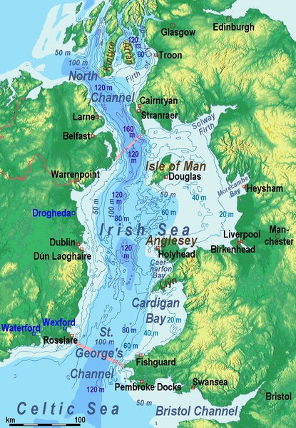
| बिबरणIrish Sea – relief, ports, limits.tif | Bathysmographic map of the en:Irish Sea. Major ports shown with red marks. freight-only ports in blue. |
| तारीख | |
| स्रोत | आपन रचना, the countures of depth are drawn by myself according to the UK source, the areal colours are derived from the Irish one. The land is from Maps for Free. |
| लेखक | Ulamm (talk) |
| Other versions |
Sources of information
- internal report Nr. 174 of the National Oceanography Centre (Liverpool)
- http://www.dcenr.gov.ie (Department of Communications, Energy and Natural Resources) -> IOSEA4Annex–Master–r02–Fiinal.pdf (Fourth Strategic Environmental Assessment for Oil and Gas ACtivity in Irelands Offshore Waters) -> figures 2.1 & 2.2a
लाइसेंसिंग
I, the copyright holder of this work, hereby publish it under the following license:
ई फाइल Creative Commons Attribution-Share Alike 3.0 Unported लाइसेंस की तहत लाइसेंसी बा।
- आप फ्री बानी:
- साझा करे खातिर – रचना के नकल करे, बाँटे आ दुसरी जगह भेजे खातिर
- रीमिक्स करे खातिर – काम के अपनी हिसाब से बनावे खातिर
- नीचे दिहल कारणन की तहत:
- एट्रीब्यूशन – लाइसेंस के कड़ी दे के उचित श्रेय (क्रेडिट) दिहल जरूरी बा आ अगर कौनों बदलाव कइल गइल बा तब ओहू के बतावल जाए के चाहीं। आप ई काम कौनों उचित तरीका से क सकत बानी, बाकी ई न झलके के चाहीं की जेकरा लगे लाइसेंस बा ऊ राउर चाहे राउर काम के समर्थन करत बाटे या सही बतावत बा।
- शेयर अलाइक (share alike) – अगर आप एह सामग्री के आधार बना के कुछ रिमिक्स करत बानी, रूप बदलाव करत बानी, चाहे कुछ जोड़ के सामग्री के बढ़ावत बानी, आपके आपन योगदान ठीक एही या कंपेटिबल लाइसेंस जइसन कि ओरिजनल बाटे, के तहत होखे के चाहीं।
Captions
Add a one-line explanation of what this file represents
Items portrayed in this file
depicts अंगरेजी
creator अंगरेजी
some value
copyright status अंगरेजी
copyrighted अंगरेजी
inception अंगरेजी
१५ दिसंबर 2014
source of file अंगरेजी
original creation by uploader अंगरेजी
फाइल के इतिहास
ओ समय ई फाइल कइसन लउके ई देखे खातिर कौनों तारीख/समय पर क्लिक करीं।
| तारीख/समय | चिप्पी रूप | डाइमेंशन | प्रयोगकर्ता | टिप्पणी | |
|---|---|---|---|---|---|
| वर्तमान | 15:17, 14 दिसंबर 2014 |  | 1,043 × 1,507 (4.5 MB) | Ulamm | {{Information |Description = Bathysmographic map of the en:Irish Sea. Major ports shown with red marks. freight-only ports in blue. |Source = {{own}}, the countures of depth are drawn by myself according to the UK source, the areal colours are der... |
फाइल के उपयोग
फाइल के इस्तेमाल पन्ना करत बा:
बैस्विक फाइल उपयोग
नीचे दिहल अउरी विकिसभ पर एह फाइल के इस्तेमाल हो रहल बा:
- azb.wikipedia.org पर इस्तेमाल
- bar.wikipedia.org पर इस्तेमाल
- ckb.wikipedia.org पर इस्तेमाल
- de.wikipedia.org पर इस्तेमाल
- en.wikipedia.org पर इस्तेमाल
- eu.wikipedia.org पर इस्तेमाल
- frr.wikipedia.org पर इस्तेमाल
- fr.wikipedia.org पर इस्तेमाल
- fy.wikipedia.org पर इस्तेमाल
- gl.wikipedia.org पर इस्तेमाल
- hsb.wikipedia.org पर इस्तेमाल
- li.wiktionary.org पर इस्तेमाल
- lv.wikipedia.org पर इस्तेमाल
- nl.wikipedia.org पर इस्तेमाल
- pt.wikipedia.org पर इस्तेमाल
- sr.wikipedia.org पर इस्तेमाल
- sw.wikipedia.org पर इस्तेमाल
- th.wikipedia.org पर इस्तेमाल
- uz.wikipedia.org पर इस्तेमाल
- vi.wikipedia.org पर इस्तेमाल
- vls.wikipedia.org पर इस्तेमाल
मेटाडाटा
ए फाइल में एक्स्ट्रा जानकारी उपलब्ध बा, हो सकत बा कि ई डिजिटल कैमरा या स्कैनर से लेवल गइल होखे। अगर ई वर्तमान फाइल एकरी ओरिजनल फाइल से सुधार के बनल बा त हो सकेला कुछ जानकारी ना लउके।
| Width | 1,043 px |
|---|---|
| Height | 1,507 px |
| Bits per component |
|
| Compression scheme | Uncompressed |
| Pixel composition | RGB |
| Image data location | 2,534 |
| Number of components | 3 |
| Number of rows per strip | 1,507 |
| Bytes per compressed strip | 4,715,403 |
| Horizontal resolution | 72 dpi |
| Vertical resolution | 72 dpi |
| Data arrangement | chunky format |