Payl:Haarlem_centrum.png
From Wikipedia, the free encyclopedia
Gidak-on ning maong paunang tan-aw: 540 x 599 ka mga piksel. Uban pang mga resoluyon: 216 x 240 ka mga piksel | 432 x 480 ka mga piksel | 674 x 748 ka mga piksel.
Tibuok resolusyon (674 × 748 pixels, size sa payl: 408 KB, MIME type: image/png)
Kining maong payl gikan sa Wikimedia Commons ug mahimong gigamit sa ubang proyekto. Ang deskripsyon niini didto gipakita sa ubos.
Mubong sugid:
| DeskripsyonHaarlem centrum.png |
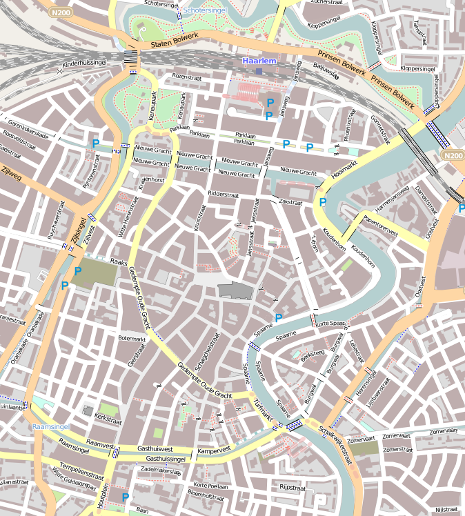
English: Map of Haarlem
Geographic limits of the map:
This file is licensed under the Creative Commons Attribution-Share Alike 2.0 Generic license.
|
| Petsa | |
| Gigikanan | OpenStreetMap |
| Tagsulat | Jane023 (talk) 15:47, 27 January 2011 (UTC) |
Pagtugot
I, the copyright holder of this work, hereby publish it under the following license:
This file is licensed under the Creative Commons Attribution-Share Alike 3.0 Unported license.
- Libre ka:
- sa pagsabwag – sa pagkopya, pag-apod-apod ug pagsabwag sa hinimo
- sa pag-remix – sa pag-adap sa binuhat
- Ubos sa mosunod nga mga kondisyon:
- atribusyon – Kinahanglan nimo nga hatagan ang angay nga kredito, maghatag usa ka link sa lisensya, ug ipakita kung adunay mga pagbag-o. Mahimo nimo kini buhaton sa bisan unsang makatarunganon nga paagi, apan dili sa bisan unsang paagi nga nagsugyot nga gi-endorso ka sa licensor o ang imong paggamit.
- share parehas – Kung imong gi-remix, gibag-o, o gibase sa materyal, kinahanglan nimo nga iapod-apod ang imong mga kontribusyon sa ilawom sa parehas o katugma nga lisensya sama sa orihinal.
Captions
Add a one-line explanation of what this file represents
Items portrayed in this file
depicts English
copyright status English
copyrighted English
27 Enero 2011
instance of English
city map English
publisher English
OpenStreetMap English
Kaagi sa payl
I-klik ang petsa/oras aron makit-an ang hulagway sa payl niadtong panahona.
| Petsa/Takna | Thumbnail | Mga dimensyon | Tiggamit | Komento | |
|---|---|---|---|---|---|
| kasamtangan | 15:47, 27 Enero 2011 | | 674 × 748 (408 KB) | Jane023 | {{Information |Description={{en|1=Map of Haarlem Geographic limits of the map: * N: 52.39015° * S: 52.37407° * W: 4.62487° * E: 4.64933° {{CC-BY-SA 2.0}} }} |Source=[http://www.openstreetmap.org/?lat=52.38211&lon=4.6371&zoom=15&layers=M OpenStree |
Mga paggamit sa payl
Ang mosunod nga mga panid misumpay niining payl:
Global nga paggamit sa payl
Kining ubang wiki naggamit ning maong payl:
- Paggamit sa ar.wikipedia.org
- Paggamit sa ca.wikipedia.org
- Paggamit sa en.wikipedia.org
- Teylers Museum
- Vleeshal
- Hofje van Bakenes
- Hofje van Noblet
- Frans Loenenhofje
- Lutherse Hofje
- Hofje van Staats
- Hofje van Loo
- Teylers Hofje
- Hofje In den Groenen Tuin
- Hofjes in Haarlem
- Wijnbergshofje
- Grote Markt (Haarlem)
- Vrouwe- en Antonie Gasthuys
- Hofje van Oorschot
- Module:Location map/data/Netherlands Haarlem/doc
- Johan Enschedé Hof
- Bakenesserkerk
- St. Barbara Gasthuis
- Module:Location map/data/Netherlands Haarlem
- Paggamit sa fa.wikipedia.org
- Paggamit sa fr.wikipedia.org
- Paggamit sa fy.wikipedia.org
- Paggamit sa ig.wikipedia.org
- Paggamit sa kn.wikipedia.org
- Paggamit sa nl.wikipedia.org
- Teylers Museum
- Amsterdamse Poort (Haarlem)
- Frans Hals Museum
- Grote of Sint-Bavokerk
- Groenmarktkerk
- Vishal (Haarlem)
- Grote Markt (Haarlem)
- Hofje van Bakenes
- Brouwershofje
- Vrouwe- en Antonie Gasthuys
- Hofje van Noblet
- Frans Loenenhofje
- Verweyhal
- Bakenesserkerk
- Gravinnehof
- Synagoge (Haarlem)
- H.H. Anna en Mariakathedraal
- Sint Josephkerk (Haarlem)
View more global usage of this file.
Gikuha gikan sa "https://ceb.wikipedia.org/wiki/Payl:Haarlem_centrum.png"