
Amakusa, Kumamoto
City in Kyushu, Japan / From Wikipedia, the free encyclopedia
Dear Wikiwand AI, let's keep it short by simply answering these key questions:
Can you list the top facts and stats about Amakusa, Kumamoto?
Summarize this article for a 10 year old
Amakusa (天草市, Amakusa-shi) is a city located in Kumamoto Prefecture, Japan.
This article needs additional citations for verification. (May 2009) |
Amakusa
天草市 | |
|---|---|
 Panorama view of Amakusa, from Jyunkyō Park | |
 Flag  Emblem | |
 Location of Amakusa in Kumamoto Prefecture | |
 | |
 Amakusa Location in Japan | |
| Coordinates: 32°28′N 130°12′E | |
| Country | Japan |
| Region | Kyushu |
| Prefecture | Kumamoto Prefecture |
| Hondo City Settled | April 1, 1954 |
| Ushibuka City Settled | July 1, 1954 |
| Both Cities Mergerd | March 27, 2006[citation needed] |
| Government | |
| • Mayor | Shoji Baba |
| Area | |
| • Total | 683.82 km2 (264.02 sq mi) |
| Population (April 2024) | |
| • Total | 72,623 |
| • Density | 110/km2 (280/sq mi) |
| Time zone | UTC+09:00 (JST) |
| City hall address | 8-1 Higashihamamachi, Amakusa-shi, Kumamoto-ken 863-0014 |
| Climate | Cfa |
| Website | www |
| Symbols | |
| Bird | Larus canus |
| Flower | Hibiscus hamabo |
| Tree | Ficus superba |
| Amakusa | |||||
|---|---|---|---|---|---|
| Japanese name | |||||
| Kanji | 天草市 | ||||
| Hiragana | あまくさし | ||||
| Katakana | アマクサシ | ||||
| |||||

As of March 2024, Amakusa has an estimated population of 72,623[1] and a population density of 110 persons per km2. The total area is 683.82 km (424.91 mi). Amakusa has the distinction of being the fastest depopulating city in Japan since the last census (2005).[citation needed]
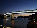 A night view of Ushibuka Haiya Bridge


Amakusa covers the majority of two main islands, Kamishima (上島, "Upper Island") and Shimoshima (下島, "Lower Island") (天草諸島), and six smaller islands and islets. The modern city of Amakusa was established on March 27, 2006, from a merger between the former cities of Hondo and Ushibuka, and the towns of Amakusa , Ariake, Goshoura, Itsuwa, Kawaura, Kuratake, Shinwa and Sumoto from Amakusa District.[citation needed]
Amakusa Airlines is headquartered in Amakusa.[2]