File:Map_of_Poland_(1945).png
From Wikipedia, the free encyclopedia
No higher resolution available.
Map_of_Poland_(1945).png (594 × 513 pixels, file size: 13 KB, MIME type: image/png)
| This is a file from the Wikimedia Commons. Information from its description page there is shown below. Commons is a freely licensed media file repository. You can help. |

|
This historical map image could be re-created using vector graphics as an SVG file. This has several advantages; see Commons:Media for cleanup for more information. If an SVG form of this image is available, please upload it and afterwards replace this template with
{{vector version available|new image name}}.
It is recommended to name the SVG file “Map of Poland (1945).svg”—then the template Vector version available (or Vva) does not need the new image name parameter. |
| Datasource (reference to visualized facts) is not provided for the data that is visualized in this self-made work. |
Summary
| DescriptionMap of Poland (1945).png |
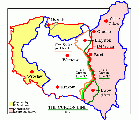
English: Map of Poland in 1945.
Deutsch: Karte Polens (1945). |
| Date | |
| Source | Own work (originally at en.wikipedia) |
| Author | Adam Carr |
| Other versions | Derivative works of this file: Polszczyzna kresowa.png |
Licensing
| Public domainPublic domainfalsefalse |
| |
This work has been released into the public domain by its author, Adam Carr, at the English Wikipedia project. This applies worldwide. In case this is not legally possible: |
Captions
Add a one-line explanation of what this file represents
Položky vyobrazené v tomto souboru
depicts
2 December 2005
File history
Click on a date/time to view the file as it appeared at that time.
| Date/Time | Thumbnail | Dimensions | User | Comment | |
|---|---|---|---|---|---|
| current | 18:29, 18 June 2018 | | 594 × 513 (13 KB) | Julieta39 | According with 1919 maps |
| 03:57, 30 June 2016 |  | 594 × 513 (15 KB) | Poeticbent | r/m dead space, spelling | |
| 07:58, 12 February 2007 |  | 617 × 513 (9 KB) | Unomano | Map of Poland in 1945, drawn by en:User: Adam Carr. From en:Image:Map of Poland (1945).png {{PD-user-w|en|English Wikipedia|Adam Carr}} Category:Maps of the history of Poland | |
| 14:43, 2 December 2005 |  | 617 × 513 (9 KB) | Thuresson | Map of Poland in 1945, drawn by User: Adam Carr. From en:Image:Map of Poland (1945).png {{PD-user-w|en|English Wikipedia|Adam Carr}} Category:Historical maps of Poland |
.png)
File usage
The following pages on the English Wikipedia use this file (pages on other projects are not listed):
- History of German settlement in Central and Eastern Europe
- Polish People's Republic
- Polish population transfers (1944–1946)
- Talk:Flight and expulsion of Germans (1944–1950)/Archive 10
- User:Adam Carr/My archive of original cartographic contributions
- User:Falcaorib
- User:Halibutt/expulsion
- User:Landau7
- User:TheNoiseBringer
Global file usage
The following other wikis use this file:
- Usage on ang.wikipedia.org
- Usage on ar.wikipedia.org
- Usage on be-tarask.wikipedia.org
- Usage on be.wikipedia.org
- Usage on bg.wikipedia.org
- Usage on ca.wikipedia.org
- Usage on cs.wikipedia.org
- Usage on de.wikibooks.org
- Usage on el.wikipedia.org
- Usage on es.wikipedia.org
- Usage on fa.wikipedia.org
- Usage on fr.wikipedia.org
- Usage on id.wikipedia.org
- Usage on it.wikipedia.org
- Usage on kk.wikipedia.org
- Usage on lv.wikipedia.org
- Usage on nl.wikipedia.org
- Usage on pt.wikipedia.org
- Usage on ro.wikipedia.org
- Usage on ru.wikipedia.org
- Usage on sk.wikipedia.org
- Usage on sr.wikipedia.org
- Usage on tr.wikipedia.org
View more global usage of this file.
.png)
Metadata
This file contains additional information, probably added from the digital camera or scanner used to create or digitize it.
If the file has been modified from its original state, some details may not fully reflect the modified file.
| Horizontal resolution | 28.35 dpc |
|---|---|
| Vertical resolution | 28.35 dpc |
Retrieved from "https://en.wikipedia.org/wiki/File:Map_of_Poland_(1945).png"