File:Micronesia_and_Marshall_islands_bathymetry.pdf
From Wikipedia, the free encyclopedia
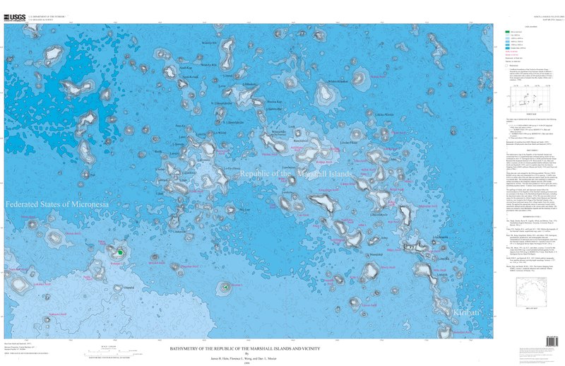
Size of this JPG preview of this PDF file: 800 × 518 pixels. Other resolutions: 320 × 207 pixels | 640 × 415 pixels | 1,024 × 663 pixels | 1,280 × 829 pixels | 2,560 × 1,658 pixels | 8,231 × 5,331 pixels.
Original file (8,231 × 5,331 pixels, file size: 16.49 MB, MIME type: application/pdf)
| This is a file from the Wikimedia Commons. Information from its description page there is shown below. Commons is a freely licensed media file repository. You can help. |
Summary
| DescriptionMicronesia and Marshall islands bathymetry.pdf |
Français : Carte bathymétrique des monts sous-marins et des îles de Micronésie et des Îles Marshall. |
| Date | |
| Source | https://ngmdb.usgs.gov/Prodesc/proddesc_33349.htm |
| Author | James R. Hein, Florence L. Wong, Dan L. Mosier |
Licensing
| Public domainPublic domainfalsefalse |
This image is in the public domain in the United States because it only contains materials that originally came from the United States Geological Survey, an agency of the United States Department of the Interior. For more information, see the official USGS copyright policy.
Bahasa Indonesia ∙ català ∙ čeština ∙ Deutsch ∙ eesti ∙ English ∙ español ∙ français ∙ galego ∙ italiano ∙ Nederlands ∙ português ∙ polski ∙ sicilianu ∙ suomi ∙ Tiếng Việt ∙ Türkçe ∙ български ∙ македонски ∙ русский ∙ മലയാളം ∙ 한국어 ∙ 日本語 ∙ 中文 ∙ 中文(简体) ∙ 中文(繁體) ∙ العربية ∙ فارسی ∙ +/− |
Captions
Add a one-line explanation of what this file represents
Items portrayed in this file
depicts
1999
application/pdf
File history
Click on a date/time to view the file as it appeared at that time.
| Date/Time | Thumbnail | Dimensions | User | Comment | |
|---|---|---|---|---|---|
| current | 19:56, 17 September 2019 |  | 8,231 × 5,331 (16.49 MB) | Sémhur | == {{int:filedesc}} == {{Information |Description = A bathymetric map of seamounts and islands in Micronesia and the Marshall Islands |Source = https://ngmdb.usgs.gov/Prodesc/proddesc_33349.htm |Date = 1999 |Author = James R. Hein, Florence L. Wong, Dan L. Mosier }} == {{int:license-header}} == {{PD-USGov-USGS}} Category:Geography of the Marshall Islands Category:Geography of the Federated States of Micronesia |
File usage
The following pages on the English Wikipedia use this file (pages on other projects are not listed):
Global file usage
The following other wikis use this file:
- Usage on de.wikipedia.org
- Usage on fr.wikipedia.org
- Usage on ru.wikipedia.org
Metadata
This file contains additional information, probably added from the digital camera or scanner used to create or digitize it.
If the file has been modified from its original state, some details may not fully reflect the modified file.
| Short title | USGS Miscellaneous Field Studies Map MF-2324 |
|---|---|
| Image title | Bathymetry of the Republic of the Marshall Islands and vicinity |
| Author | Hein, J.R., Wong, F.L., and Mosier, D.L. |
| Keywords |
|
| Software used | pdftk 1.44 - www.pdftk.com |
| Conversion program | itext-paulo-155 (itextpdf.sf.net-lowagie.com) |
| Encrypted | no |
| Page size | 3951 x 2559 pts |
| Version of PDF format | 1.4 |