File:World-airline-routemap-2009.png
From Wikipedia, the free encyclopedia
Size of this preview: 800 × 400 pixels. Other resolutions: 320 × 160 pixels | 640 × 320 pixels | 1,024 × 513 pixels | 1,280 × 641 pixels | 2,048 × 1,025 pixels.
Original file (2,048 × 1,025 pixels, file size: 2.43 MB, MIME type: image/png)
| This is a file from the Wikimedia Commons. Information from its description page there is shown below. Commons is a freely licensed media file repository. You can help. |
Summary
| DescriptionWorld-airline-routemap-2009.png |
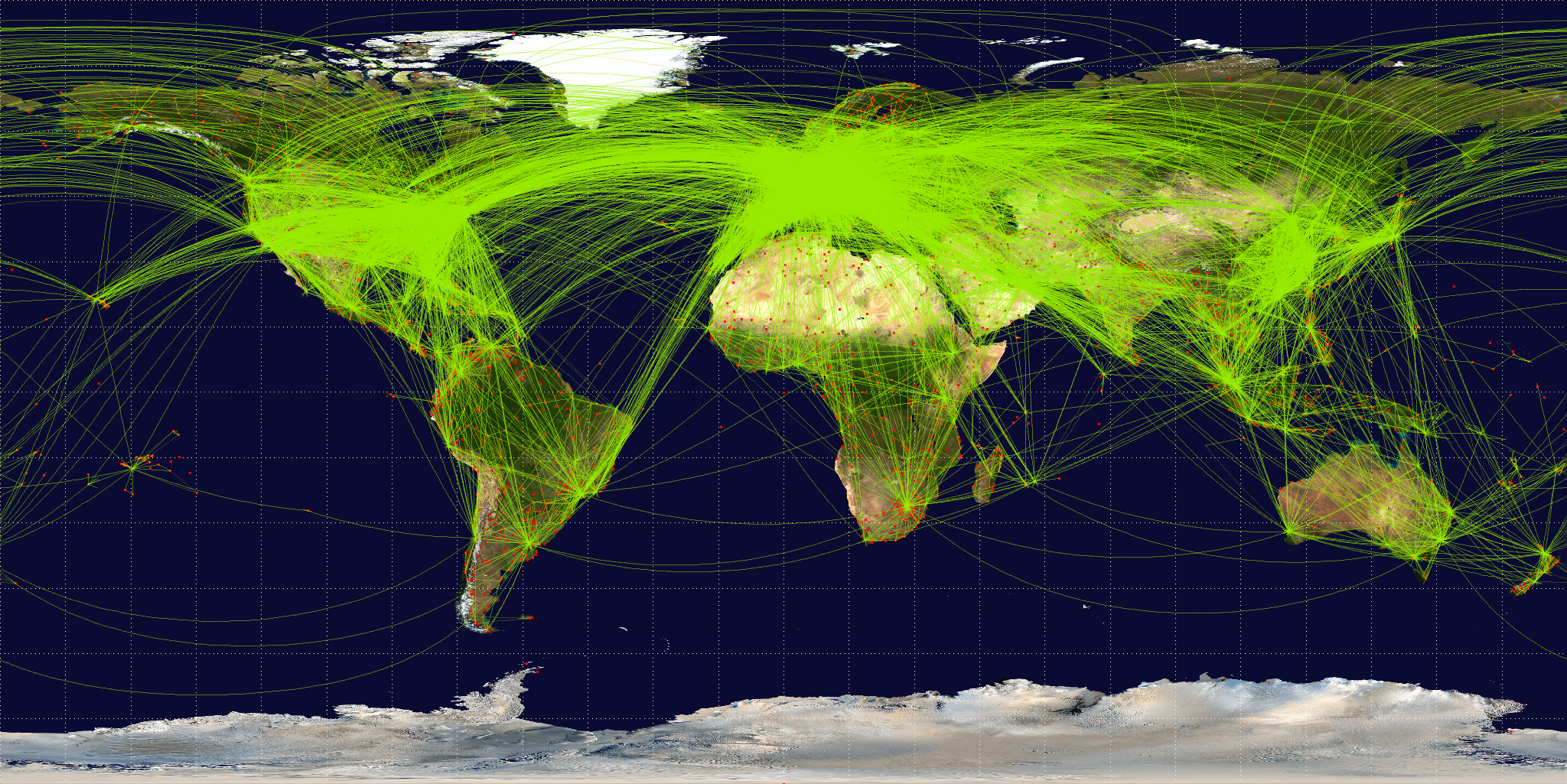
English: Map of scheduled airline traffic around the world, circa June 2009. Contains 54317 routes, rendered at 25% transparency.
Base map is NASA Blue Marble (PD) plus airports from file:World-airport-map-2008.png, route data is from Airline Route Mapper, rendering by OpenFlights (Open Database License). PHP source code for rendering available at the OpenFlights SVN. |
||
| Date | |||
| Source | Own work | ||
| Author | Jpatokal | ||
| Other versions |
|

I, the copyright holder of this work, hereby publish it under the following licenses:
This file is licensed under the Creative Commons Attribution-Share Alike 3.0 Unported, 2.5 Generic, 2.0 Generic and 1.0 Generic license.
- You are free:
- to share – to copy, distribute and transmit the work
- to remix – to adapt the work
- Under the following conditions:
- attribution – You must give appropriate credit, provide a link to the license, and indicate if changes were made. You may do so in any reasonable manner, but not in any way that suggests the licensor endorses you or your use.
- share alike – If you remix, transform, or build upon the material, you must distribute your contributions under the same or compatible license as the original.

|
Permission is granted to copy, distribute and/or modify this document under the terms of the GNU Free Documentation License, Version 1.2 or any later version published by the Free Software Foundation; with no Invariant Sections, no Front-Cover Texts, and no Back-Cover Texts. A copy of the license is included in the section entitled GNU Free Documentation License.http://www.gnu.org/copyleft/fdl.htmlGFDLGNU Free Documentation Licensetruetrue |
You may select the license of your choice.
Captions
Add a one-line explanation of what this file represents
Items portrayed in this file
depicts
26 June 2009
image/png
File history
Click on a date/time to view the file as it appeared at that time.
| Date/Time | Thumbnail | Dimensions | User | Comment | |
|---|---|---|---|---|---|
| current | 07:57, 26 June 2009 | | 2,048 × 1,025 (2.43 MB) | Jpatokal | {{Information |Description={{en|1=Map of scheduled airline traffic around the world. Contains 54317 routes, rendered at 25% transparency. Base map is NASA Blue Marble (PD) plus airports from file:World-airport-map-2008.png, route data is from [http |
File usage
The following pages on the English Wikipedia use this file (pages on other projects are not listed):
Global file usage
The following other wikis use this file:
- Usage on af.wikipedia.org
- Usage on ar.wikipedia.org
- Usage on arz.wikipedia.org
- Usage on az.wikipedia.org
- Usage on be.wikipedia.org
- Usage on bg.wikipedia.org
- Usage on bn.wikipedia.org
- Usage on bs.wikipedia.org
- Usage on ca.wikipedia.org
- Usage on cs.wikipedia.org
- Usage on da.wikipedia.org
- Usage on de.wikipedia.org
- Usage on en.wikibooks.org
- Usage on es.wikipedia.org
- Usage on eu.wikipedia.org
- Usage on fa.wikipedia.org
- Usage on fi.wikipedia.org
- Usage on fr.wikipedia.org
- Usage on fr.wikiversity.org
- Usage on ga.wikipedia.org
View more global usage of this file.
Retrieved from "https://en.wikipedia.org/wiki/File:World-airline-routemap-2009.png"