
Pyrogeography
Study of the distribution of wildfires / From Wikipedia, the free encyclopedia
Dear Wikiwand AI, let's keep it short by simply answering these key questions:
Can you list the top facts and stats about Pyrogeography?
Summarize this article for a 10 year old
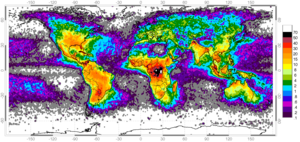
Pyrogeography is the study of the past, present, and projected distribution of wildfire. Wildland fire occurs under certain conditions of climate, vegetation, topography, and sources of ignition, such that it has its own biogeography, or pattern in space and time.[1][2] The earliest published evidence of the term appears to be in the mid-1990s, and the meaning was primarily related to mapping fires[3][4] The current understanding of pyrogeography emerged in the 2000s as a combination of biogeography and fire ecology, facilitated by the availability of global-scale datasets of fire occurrence, vegetation cover, and climate. Pyrogeography has also been placed at the juncture of biology, the geophysical environment, and society and cultural influences on fire.[5]


Pyrogeography often uses a framework of ecological niche concepts to evaluate the environmental controls on fire. By examining how environmental factors interact to facilitate fire activity, pyrogeographers can predict expected fire behavior under new conditions. Pyrogeographic research contributes to and informs land management policy in various regions across the globe.