Fichier:China-Heilongjiang.png
De Wikipedia, l'encyclopédie encyclopedia
China-Heilongjiang.png (268 × 218 pixels, taille du fichier : 31 kio, type MIME : image/png)
Ce fichier et sa description proviennent de Wikimedia Commons.


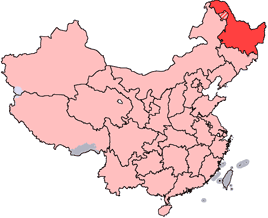
en: Location of Heilongjiang Province in the People's Republic of China. See Locator maps of province-level divisions of the People's Republic of China for more information. The striped area is administered by Daxing'anling Prefecture of Heilongjiang, but it is nominally part of Inner Mongolia Autonomous Region.
zh: 黑龍江省在中華人民共和國的位置。另見Locator maps of province-level divisions of the People's Republic of China。加斜杠的地區由黑龍江省大興安嶺地區所管轄,但在名義上為内蒙古自治區的一部分。

|
Vous avez la permission de copier, distribuer et modifier ce document selon les termes de la GNU Free Documentation License version 1.2 ou toute version ultérieure publiée par la Free Software Foundation, sans sections inaltérables, sans texte de première page de couverture et sans texte de dernière page de couverture. Un exemplaire de la licence est inclus dans la section intitulée GNU Free Documentation License.http://www.gnu.org/copyleft/fdl.htmlGFDLGNU Free Documentation Licensetruetrue |
| Ce fichier est disponible selon les termes de la licence Creative Commons Attribution – Partage dans les Mêmes Conditions 3.0 (non transposée). | ||
| ||
| Ce bandeau de licence a été ajouté à ce fichier dans le cadre de la procédure de mise à jour des licences des images sous GFDL.http://creativecommons.org/licenses/by-sa/3.0/CC BY-SA 3.0Creative Commons Attribution-Share Alike 3.0truetrue |
Légendes
Éléments décrits dans ce fichier
dépeint
image/png
9639ba8f1aeb2dc007f9ff699b6b408b1a589d7b
31 497 octet
218 pixel
268 pixel
Historique du fichier
Cliquer sur une date et heure pour voir le fichier tel qu'il était à ce moment-là.
| Date et heure | Vignette | Dimensions | Utilisateur | Commentaire | |
|---|---|---|---|---|---|
| actuel | 28 octobre 2007 à 16:45 | | 268 × 218 (31 kio) | Croquant | transparent background |
| 4 juin 2005 à 23:47 |  | 268 × 218 (9 kio) | Ran | '''en''': Location of Heilongjiang Province in the People's Republic of China. See Category:Locator maps of province-level divisions of the People's Republic of China for more information. The striped area is administered by Daxing'anling Prefecture |
Utilisation du fichier
La page suivante utilise ce fichier :
Usage global du fichier
Les autres wikis suivants utilisent ce fichier :
- Utilisation sur cy.wikipedia.org
- Utilisation sur da.wikipedia.org
- Utilisation sur de.wikipedia.org
- Utilisation sur en.wikipedia.org
- Pingfang, Harbin
- Wikipedia:WikiProject Chinese provinces/Locator maps
- Songjiang Province
- Longjiang County
- Jingpo Lake
- Wanda Mountains
- Mingshui County
- Heitai
- Kedong County
- Bei'an
- Nan'gang, Harbin
- Yabuli Ski Resort
- Ang'angxi District
- Diaoshuilou Falls
- Mudan River
- Zhalong Nature Reserve
- Nenjiang Province
- Gannan County
- Nehe
- Shuangcheng, Harbin
- Tangchi, Heilongjiang
- Tieli
- Mishan
- Baoquan, Heilongjiang
- Heihe Aihui Airport
- Yi'an Town, Heilongjiang
- Laha, Heilongjiang
- Muling
- Template:Heilongjiang-geo-stub
- Daxing'anling Prefecture
- Daoli, Harbin
- HLA-B67
- HLA-B59
Voir davantage sur l’utilisation globale de ce fichier.