קובץ:Map_of_the_Holy_Roman_Empire,_1789_en.png
ויקיפדיה האנציקלופדיה encyclopedia
גודל התצוגה המקדימה הזאת: 736 × 600 פיקסלים. רזולוציות אחרות: 295 × 240 פיקסלים | 589 × 480 פיקסלים | 942 × 768 פיקסלים | 1,256 × 1,024 פיקסלים | 2,513 × 2,048 פיקסלים | 2,650 × 2,160 פיקסלים.
לקובץ המקורי (2,650 × 2,160 פיקסלים, גודל הקובץ: 726 ק"ב, סוג MIME: image/png)
| זהו קובץ שמקורו במיזם ויקישיתוף. תיאורו בדף תיאור הקובץ המקורי (בעברית) מוצג למטה. |
תקציר
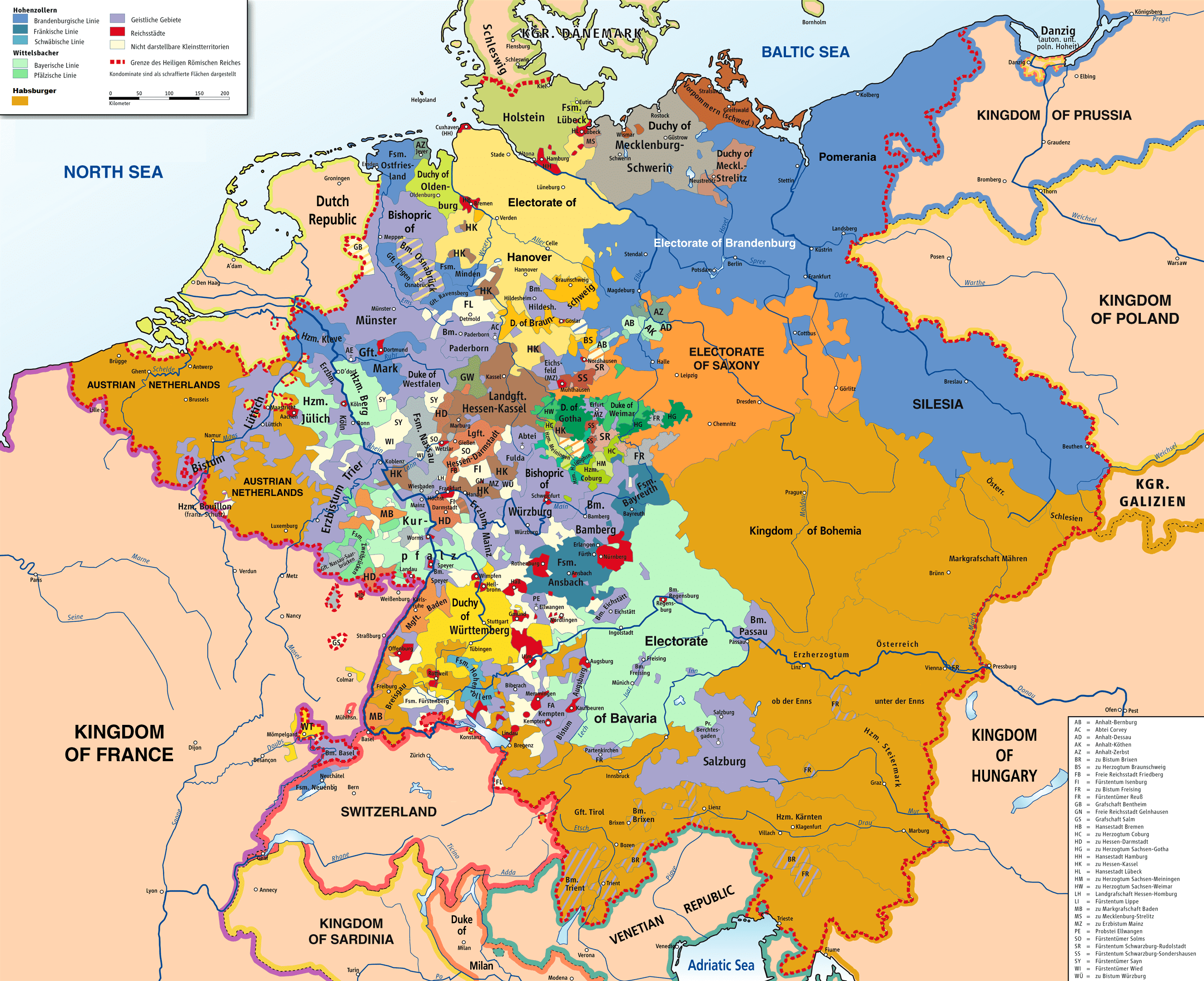
| תיאורMap of the Holy Roman Empire, 1789 en.png |
English: Map of the Holy Roman Empire, 1789. |
||
| תאריך יצירה | |||
| מקור |
נוצר על ידי מעלה היצירה בהתבסס על: HRR 1789.png "translated (somewhat) from original German version" References:
|
||
| יוצר |
Robert Alfers, ziegelbrenner |
||
| Georeferencing | Georeference the map in Wikimaps Warper If inappropriate please set warp_status = skip to hide. | ||
| גרסאות אחרות |
 Ursprungskarte in Deutsch
|

רישיון
הקובץ הזה מתפרסם לפי תנאי רישיונות קריאייטיב קומונז ייחוס-שיתוף זהה 3.0 לא מותאם, 2.5 כללי, 2.0 כללי ו־1.0 כללי.
- הנכם רשאים:
- לשתף – להעתיק, להפיץ ולהעביר את העבודה
- לערבב בין עבודות – להתאים את העבודה
- תחת התנאים הבאים:
- ייחוס – יש לתת ייחוס הולם, לתת קישור לרישיון, ולציין אם נעשו שינויים. אפשר לעשות את זה בכל צורה סבירה, אבל לא בשום צורה שמשתמע ממנה שמעניק הרישיון תומך בך או בשימוש שלך.
- שיתוף זהה – אם תיצרו רמיקס, תשנו, או תבנו על החומר, חובה עליכם להפיץ את התרומות שלך לפי תנאי רישיון זהה או תואם למקור.
כיתובים
נא להוסיף משפט שמסביר מה הקובץ מייצג
פריטים שמוצגים בקובץ הזה
מוצג
8 ביוני 2008
היסטוריית הקובץ
ניתן ללחוץ על תאריך/שעה כדי לראות את הקובץ כפי שנראה באותו זמן.
| תאריך/שעה | תמונה ממוזערת | ממדים | משתמש | הערה | |
|---|---|---|---|---|---|
| נוכחית | 17:47, 30 בנובמבר 2018 | | 2,160 × 2,650 (726 ק"ב) | FDRMRZUSA | Implemented map legend: inserted "Kilometers". |
| 01:59, 30 בנובמבר 2018 |  | 2,160 × 2,650 (810 ק"ב) | FDRMRZUSA | Implemented map legend: "Habsburger". Reduced dimensions (size). | |
| 19:17, 17 בפברואר 2013 |  | 2,160 × 2,650 (2.69 מ"ב) | Opus33 | I've added a few more English place names, as follows: Wien > Vienna Muenchen > Munich Mailand > Milan Bruessel > Brussels Prag > Prague Antwerpen > Antwerp Triest > Trieste Warschau > Warsaw Gent > Ghent Erzbistum removed from Salzburg; should be Ar... | |
| 20:08, 2 ביולי 2010 |  | 2,160 × 2,650 (2.55 מ"ב) | Ras67 | cropped | |
| 07:09, 8 ביוני 2008 |  | 2,170 × 2,659 (2.62 מ"ב) | RobNS | {{Information |Description={{en|1=Map of the Holy Roman Empire, 1789, translated (somewhat) from original German version on Wikipedia Commons}} |Source=Own source, translated map from Image:HRR 1789.png, also on WC |Author=Robert Alfers, [[:de:Benutzer:kg |
שימוש בקובץ
הדף הבא משתמש בקובץ הזה:
שימוש גלובלי בקובץ
אתרי הוויקי השונים הבאים משתמשים בקובץ זה:
- שימוש באתר als.wikipedia.org
- שימוש באתר ar.wikipedia.org
- שימוש באתר azb.wikipedia.org
- שימוש באתר az.wikipedia.org
- שימוש באתר be.wikipedia.org
- שימוש באתר bg.wikipedia.org
- שימוש באתר ca.wikipedia.org
- שימוש באתר cs.wikipedia.org
- שימוש באתר da.wikipedia.org
- שימוש באתר de.wikipedia.org
- שימוש באתר el.wikipedia.org
- שימוש באתר en.wikipedia.org
- Battle of Rastatt (1796)
- Imperial immediacy
- Unification of Germany
- German mediatisation
- Kleinstaaterei
- Names of Germany
- Army of Sambre and Meuse
- Talk:Holy Roman Empire/Archive 1
- Austria–Germany relations
- Siege of Kehl (1796–1797)
- Wikipedia:Graphics Lab/Map workshop/Archive/Dec 2012
- Nationality of Wolfgang Amadeus Mozart
- Rhine campaign of 1796
- User:Dainomite/sandbox
- Dissolution of the Holy Roman Empire
- Rhine campaign of 1795
- Battle of Kehl (1796)
- Siege of Hüningen (1796–1797)
- Wikipedia:Village pump (technical)/Archive 144
- User:JMvanDijk/Sandbox 10
- Early clashes in the Rhine campaign of 1796
- User:Falcaorib
- User:Bunhouse768/sandbox
- User:Dronebogus/Don’t Balkanize Wikipedia
- שימוש באתר es.wikipedia.org