Bestand:USSR_Republics_Numbered_Alphabetically.png
Uit Wikipedia, de vrije encyclopedia
Oorspronkelijk bestand (1.356 × 928 pixels, bestandsgrootte: 80 kB, MIME-type: image/png)
| Dit is een bestand van Wikimedia Commons. Onderstaande beschrijving komt van de beschrijving van het bestand daar. |


Beschrijving
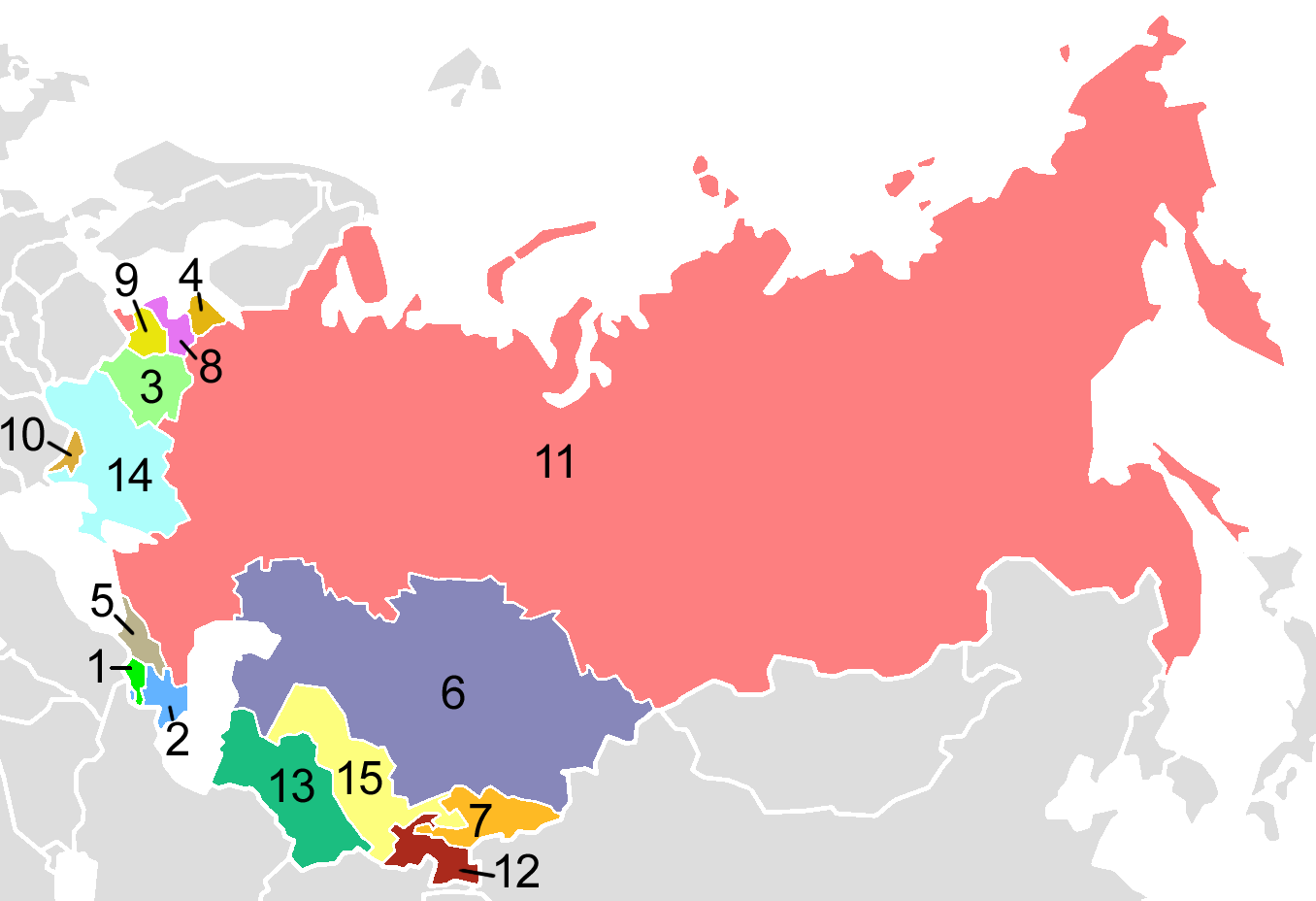
USSR Republics, numbered alphabetically.
Post-Soviet states in English alphabetical order:
| 1. | Armenia |
| 2. | Azerbaijan |
| 3. | Belarus |
| 4. | Estonia |
| 5. | Georgia |
| 6. | Kazakhstan |
| 7. | Kyrgyzstan |
| 8. | Latvia |
| 9. | Lithuania |
| 10. | Moldova |
| 11. | Russia |
| 12. | Tajikistan |
| 13. | Turkmenistan |
| 14. | Ukraine |
| 15. | Uzbekistan |
Map created by en:User:Aris_Katsaris, based on Image:Soviet Union Map.png in mimicry of the concept of fr:Image:USSR_Republics_Numbered_Alphabetically.png.
Licentie
| Public domainPublic domainfalsefalse |
| This map is ineligible for copyright and therefore in the public domain, because it consists entirely of information that is common property and contains no original authorship. For more information, see Commons:Threshold of originality § Maps.
English | Español | Galego | Română | slovenščina | العربية | 简体中文 | 繁體中文 | +/− |
Derivative works
Afgeleide werken van dit bestand: Soviet Socialist Republics numbered by the Soviet constitution.png
| Aantekeningen InfoField | Deze afbeelding is aangetekend: Bekijk de aantekeningen op Commons |
Carte de l'Union des Républiques Socialistes Soviétiques
Bijschriften
Items getoond in dit bestand
beeldt af
image/png
Bestandsgeschiedenis
Klik op een datum/tijd om het bestand te zien zoals het destijds was.
| Datum/tijd | Miniatuur | Afmetingen | Gebruiker | Opmerking | |
|---|---|---|---|---|---|
| huidige versie | 3 aug 2009 05:40 | | 1.356 × 928 (80 kB) | Hoshie | Added border for N. Ireland; spilit Germany so that this map dates from 1988-89 |
| 10 okt 2008 23:06 |  | 1.356 × 928 (52 kB) | Milosevo | {{Information |Description= |Source= |Date= |Author= |Permission= |other_versions= }} | |
| 15 apr 2005 05:38 |  | 1.356 × 928 (46 kB) | Aris Katsaris | USSR Republics, numbered alphabetically. Created by User:Aris Katsaris, based on Image:Soviet Union Map.png, in mimicry of the concept of en:Image:Soviet republics.jpg. {{GFDL}} Category:Political divisions of the Soviet Union [[Categor |
Bestandsgebruik
Dit bestand wordt op de volgende 4 pagina's gebruikt:
Globaal bestandsgebruik
De volgende andere wiki's gebruiken dit bestand:
- Gebruikt op af.wikipedia.org
- Gebruikt op als.wikipedia.org
- Gebruikt op ar.wikipedia.org
- Gebruikt op ast.wikipedia.org
- Gebruikt op avk.wikipedia.org
- Gebruikt op azb.wikipedia.org
- Gebruikt op ban.wikipedia.org
- Gebruikt op bar.wikipedia.org
- Gebruikt op be-tarask.wikipedia.org
- Gebruikt op bg.wikipedia.org
- Gebruikt op br.wikipedia.org
- Gebruikt op bs.wikipedia.org
- Gebruikt op ca.wikipedia.org
- Gebruikt op ckb.wikipedia.org
- Gebruikt op cs.wikipedia.org
- Gebruikt op cv.wikipedia.org
- Gebruikt op cy.wikipedia.org
- Gebruikt op da.wikipedia.org
- Sovjetunionen
- Bruger:Rasmus81/Sandkasse2
- Jødiske autonome oblast
- Russiske SFSR
- Sovjetrepublik
- Karelsk-finske SSR
- Lettiske SSR
- Aserbajdsjanske SSR
- Skabelon:Navboks Sovjetunionens administrative inddeling
- Hviderussiske SSR
- Ukrainske SSR
- Karelske ASSR
- Litauiske SSR
- Estiske SSR
- Autonome Socialistiske Sovjetrepublikker i Sovjetunionen
- SNG ved OL
- Tadsjikiske SSR
- Georgiske SSR
Globaal gebruik van dit bestand bekijken.
Metadata
Dit bestand bevat metadata met EXIF-informatie, die door een fotocamera, scanner of fotobewerkingsprogramma toegevoegd kan zijn.
| Tijdstip laatste bestandswijziging | 10 okt 2008 21:05 |
|---|