فائل:Ghaznavid_Empire_975_-_1187_(AD).PNG
From Wikipedia, the free encyclopedia
اس توں وڈی مورت موجود نہیں۔
Ghaznavid_Empire_975_-_1187_(AD).PNG (۶۲۰ × ۴۲۸ پکسلز, فائل حجم: ۲۰ کلوبائٹ, MIME type: image/png)
ایہ فائل Wikimedia Commons توں اے تے دوجیاں ویونتاں تے وی ورتی جاسکدی اے۔ گل بات اس دے فائل گل بات صفحہ تے تھلے دتی گئی۔
خلاصہ
| تفصیلGhaznavid Empire 975 - 1187 (AD).PNG |
Polski: Państwo Ghaznawidów
English: Ghaznavid Empire |
| تریخ | |
| سروت | آپݨا کم |
| لکھاری | Arab League |
| دوجے ورژن | Arabic |
-ar.PNG)
لائسنس –
| Public domainPublic domainfalsefalse |
| اس کم نوں لوکاں لئی ایدے لکھاریArab League at English وکیپیڈیا نے دے دتا اے، اے سارے جگ واسطے لاگو اے۔ کج ملکاں چ قانونی طور تے اے ممکن نئیں اے؛ اگر انج ای اے ے: Arab League ہر کسے نوں اس کم نوں کسے وی مقصد واسطے ورتن دا بغیر کسے شرط دے حق دیندا واں، اگر اوہ قانون دے خلاف نا ہوۓ۔Public domainPublic domainfalsefalse |
Captions
Add a one-line explanation of what this file represents
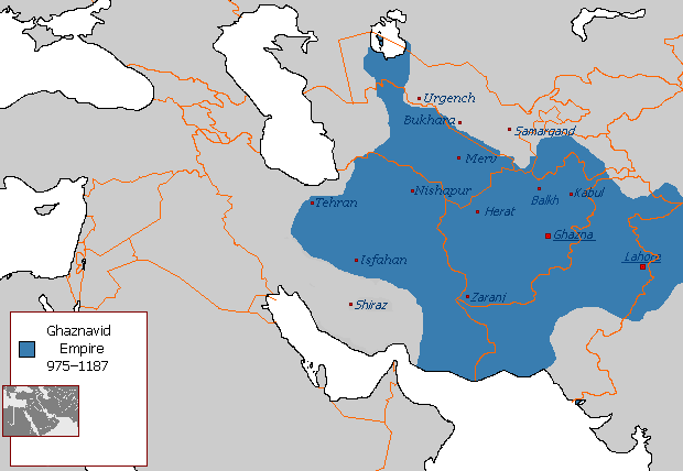
نقشهٔ قلمروی دودمان غزنویان
Items portrayed in this file
چترن
۲۹ اگست 2007
فائل دی تریخ
فائل نو اس ویلے دی حالت وچ ویکھن واسطے تاریخ/ویلے تے کلک کرو۔
| تریخ تے ویلہ | نکی مورت | پاسے | ورتن والا | تیپّݨی کرو | |
|---|---|---|---|---|---|
| موجودہ | ۰۹:۵۴, ۷ جولائی ۲۰۱۵ | | ۶۲۰ × ۴۲۸ (۲۰ کلوبائٹ) | HistoryofIran | Of course Iranica doesn't, it states which areas they ruled at their extent, stop making reverts without discussing.. |
| ۰۶:۰۵, ۴ جولائی ۲۰۱۵ |  | ۶۱۹ × ۴۲۸ (۲۱ کلوبائٹ) | Persia10101 | More accurate map after some research | |
| ۰۶:۰۵, ۴ جولائی ۲۰۱۵ |  | ۶۱۹ × ۴۲۸ (۲۱ کلوبائٹ) | Persia10101 | More accurate map after some research | |
| ۰۵:۵۸, ۴ جولائی ۲۰۱۵ |  | ۶۲۰ × ۴۲۸ (۲۶ کلوبائٹ) | Persia10101 | Iranica doesnt show a map. reverting to the more commonly agreed map | |
| ۰۵:۵۷, ۴ جولائی ۲۰۱۵ |  | ۶۲۰ × ۴۲۸ (۲۶ کلوبائٹ) | Persia10101 | Reverted to version as of 08:05, 14 August 2011 | |
| ۱۷:۰۸, ۹ مئی ۲۰۱۴ |  | ۶۲۰ × ۴۲۸ (۲۰ کلوبائٹ) | HistoryofIran | Further fixed the map, i will be adding vassals later. | |
| ۰۴:۴۷, ۲۹ جنوری ۲۰۱۴ |  | ۶۲۰ × ۴۲۸ (۲۰ کلوبائٹ) | HistoryofIran | Fars and Kerman remained under Buyid rule until the Seljuqs came. | |
| ۲۰:۰۱, ۷ جون ۲۰۱۳ |  | ۶۲۰ × ۴۲۸ (۲۰ کلوبائٹ) | HistoryofIran | Fixed the map, according to Iranica the map was like this at it's greatest extent. | |
| ۱۹:۵۸, ۷ جون ۲۰۱۳ |  | ۶۲۰ × ۴۲۸ (۲۰ کلوبائٹ) | HistoryofIran | Fixed the map, according to Iranica the map was like this at it's greatest extent. | |
| ۱۹:۵۴, ۷ جون ۲۰۱۳ |  | ۶۲۰ × ۴۲۸ (۲۰ کلوبائٹ) | HistoryofIran | Fixed the map, according to Iranica the map was like this at it's greatest extent. |
فائل دی ورتوں
تھلے دتے گئے 6 صفحے اس فائل نال جُڑدے نیں
فائل ویاپک ورتوں
ایہہ دوجے وکیاں ایس فائل نوں ورتدے نیں –
- arz.wikipedia.org تے ورتوں
- ast.wikipedia.org تے ورتوں
- av.wikipedia.org تے ورتوں
- azb.wikipedia.org تے ورتوں
- az.wikipedia.org تے ورتوں
- ba.wikipedia.org تے ورتوں
- be.wikipedia.org تے ورتوں
- bg.wikipedia.org تے ورتوں
- bn.wikipedia.org تے ورتوں
- ca.wikipedia.org تے ورتوں
- ceb.wikipedia.org تے ورتوں
- ckb.wikipedia.org تے ورتوں
- da.wikipedia.org تے ورتوں
- de.wikipedia.org تے ورتوں
- el.wikipedia.org تے ورتوں
- en.wikipedia.org تے ورتوں
- Muslim conquests of Afghanistan
- History of Afghanistan
- Turkic peoples
- Greater Iran
- Jasrota
- User:Arab Hafez/Map
- Portal:Afghanistan
- Shia Islam in the Indian subcontinent
- User:Ottava Rima/Persian Empire
- User:Sobreira/Religion
- Muslim conquest of Khorasan
- Nurpur kingdom
- User:Northamerica1000/Portals of the world
- User:Kansas Bear/Ghaznavids
- User:Kypioys sx/sandbox
- User:Kansas Bear/Saffarid dynasty
- eo.wikipedia.org تے ورتوں
- es.wikipedia.org تے ورتوں
ایس فائل دا ویکھو ہور جگت ورتن .
.PNG)
میٹا ڈیٹا
اس فائل وچ ہور وی معلومات نے، شاید او ڈیجیٹل کیمرے یا سکینر نے پائیاں گئیاں نے جس نال اینو کچھیا یا ڈیجیٹل بنایا گیا اے۔
اگر فائل نو ایدی اصلی حالت توں تبدیل کیتا گیا اے تے کجھ تفصیلات تبدیل ہوئی فائل دے بارے چ نئیں دسن گیاں۔
| ہوریزنٹل ریزولوشن | ۲۸.۳۵ dpc |
|---|---|
| ورٹیکل ریزولوشن | ۲۸.۳۵ dpc |
.PNG)