File:Kingdoms_of_the_Levant_Map_830.xcf
維基百科,自由的 encyclopedia
此XCF文件的PNG预览的大小:503 × 600像素。 其他分辨率:201 × 240像素 | 402 × 480像素 | 644 × 768像素 | 858 × 1,024像素 | 1,955 × 2,332像素。
原始文件 (1,955 × 2,332像素,文件大小:941 KB,MIME类型:image/x-xcf)
|
|
摘要
| 描述Kingdoms of the Levant Map 830.xcf |
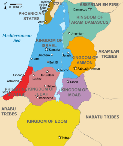
English: Map showing Kingdoms of the Levant c 830. The Kingdoms:
العربية: خريطة توضح ممالك بلاد الشام ج 830. الممالك:
فينيقيا - بني ارام دمشق - زبرجد آمون - البرتقالي موآب - بنفسجي ايدوم - الأصفر فلسطين - أحمر يهوذا - مارون تُظهر الخريطة المنطقة في القرن التاسع قبل الميلاد. |
| 日期 | (UTC) |
| 来源 |
本檔案衍生自: |
| 作者 |
|
| 其他版本 | 此文件衍生的作品: Kingdoms of the Levant Map 830.png |


| 这是一张修改过的图片,这意味着它已在原版本的基础上通过软件进行了编辑,改动内容:Added colours for the two kingdoms。其原始版本为:Kingdoms of Israel and Judah map 830.svg。修改者:Dlv999。
|
许可协议
本文件采用知识共享署名-相同方式共享 3.0 未本地化版本许可协议授权。
- 您可以自由地:
- 共享 – 复制、发行并传播本作品
- 修改 – 改编作品
- 惟须遵守下列条件:
- 署名 – 您必须对作品进行署名,提供授权条款的链接,并说明是否对原始内容进行了更改。您可以用任何合理的方式来署名,但不得以任何方式表明许可人认可您或您的使用。
- 相同方式共享 – 如果您再混合、转换或者基于本作品进行创作,您必须以与原先许可协议相同或相兼容的许可协议分发您贡献的作品。
原始上传日志
This image is a derivative work of the following images:
- File:Kingdoms_around_Israel_830_map.svg licensed with Cc-by-sa-3.0, GFDL
- 2010-07-13T12:58:31Z Richardprins 720x859 (169373 Bytes) livened up the colors, converted med sea text to path
- 2010-07-13T11:26:40Z Richardprins 720x859 (141985 Bytes) {{Information |Description={{en|1=Map showing the ancient levant borders and ancient cities such as [[Urmomium]] and [[Jerash]]. The Kingdoms around Israel and Judah are colored. The map also shows the region in the 9th centu
- File:Kingdoms_of_Israel_and_Judah_map_830.svg licensed with Cc-by-sa-3.0, GFDL
- 2011-02-12T23:48:05Z Richardprins 720x859 (80190 Bytes) -
- 2010-07-13T11:29:47Z Richardprins 720x859 (80899 Bytes) Fixed Judah color
- 2010-07-13T10:51:49Z Richardprins 720x859 (80858 Bytes) Added colors for the two kingdoms and converted their text to path and arial
- 2010-07-12T23:53:35Z Richardprins 720x859 (63843 Bytes) Shrinked down the borders
- 2010-07-12T19:43:31Z Richardprins 720x859 (63800 Bytes) {{Information |Description={{en|1=Map showing the ancient levant borders and ancient cities such as [[Urmomium]] and [[Jerash]]. The map also shows the region in the 9th century BCE. Notice the coastal land of Philistia, from
Uploaded with derivativeFX
说明
添加一行文字以描述该文件所表现的内容
此文件中描述的项目
描繪內容
12 3 2012
image/x-xcf
文件历史
点击某个日期/时间查看对应时刻的文件。
| 日期/时间 | 缩略图 | 大小 | 用户 | 备注 | |
|---|---|---|---|---|---|
| 当前 | 2012年3月12日 (一) 11:26 |  | 1,955 × 2,332(941 KB) | Dlv999 | == {{int:filedesc}} == {{Information |Description={{en|1=Map showing Kingdoms of the Levant c 830. The Kingdoms: * Phoenicia -Brown * Aram Damascus - Aquamarine * Amon - Orange * Moab - Purple * Edom - Yellow * Philistia - Red * Israel - Blue) *... |
文件用途
没有页面链接到本图像。
全域文件用途
以下其他wiki使用此文件:
- ar.wikipedia.org上的用途
- hr.wikipedia.org上的用途
- mg.wikipedia.org上的用途