File:Map_administrative_divisions_of_the_First_French_Empire_1812-en.svg
維基百科,自由的 encyclopedia

此SVG文件的PNG预览的大小:712 × 600像素。 其他分辨率:285 × 240像素 | 570 × 480像素 | 912 × 768像素 | 1,216 × 1,024像素 | 2,432 × 2,048像素 | 2,052 × 1,728像素。
原始文件 (SVG文件,尺寸为2,052 × 1,728像素,文件大小:3.86 MB)
摘要
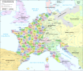
| 描述Map administrative divisions of the First French Empire 1812-en.svg |
Català: Divisions administratives del Primer Imperi Francès el 1812
English: Administrative divisions of the First French Empire in 1812 |
| 日期 | |
| 来源 |
|
| 作者 | Andrein |
| 其他版本 |
Other related versions:[编辑]
|


| 此SVG檔案包含可翻譯至您的語言的内嵌文字,可以使用任何可用SVG編輯器、文本編輯器或SVG翻譯工具來翻譯。詳情請見:關於翻譯SVG檔案。 |
此檔案使用SVG <switch>元素翻譯。所有的譯文都儲存在同一檔案中!了解更多。
請在 要將此檔案中的文字翻譯成您的語言,您可以使用SVG 翻譯工具。或者,您可以將該檔案下載至您的電腦中,使用您熟悉的任何軟體進行翻譯,然後使用「相同」名稱重新上傳。如果不確定如何進行此操作,您能在圖像實驗室中找到幫助。 |
许可协议
我,本作品著作权人,特此采用以下许可协议发表本作品:
本文件采用知识共享署名-相同方式共享 4.0 国际许可协议授权。
- 您可以自由地:
- 共享 – 复制、发行并传播本作品
- 修改 – 改编作品
- 惟须遵守下列条件:
- 署名 – 您必须对作品进行署名,提供授权条款的链接,并说明是否对原始内容进行了更改。您可以用任何合理的方式来署名,但不得以任何方式表明许可人认可您或您的使用。
- 相同方式共享 – 如果您再混合、转换或者基于本作品进行创作,您必须以与原先许可协议相同或相兼容的许可协议分发您贡献的作品。
说明
添加一行文字以描述该文件所表现的内容
此文件中描述的项目
描繪內容
19 7 2015
image/svg+xml
文件历史
点击某个日期/时间查看对应时刻的文件。
| 日期/时间 | 缩略图 | 大小 | 用户 | 备注 | |
|---|---|---|---|---|---|
| 当前 | 2024年2月9日 (五) 12:33 | | 2,052 × 1,728(3.86 MB) | Manlleus | added catalan language |
| 2021年5月21日 (五) 17:10 |  | 2,052 × 1,728(3.55 MB) | Andrei Stroe | File uploaded using svgtranslate tool (https://svgtranslate.toolforge.org/). Added translation for ro. | |
| 2020年8月30日 (日) 12:32 |  | 2,052 × 1,728(3.24 MB) | Jfblanc | File uploaded using svgtranslate tool (https://svgtranslate.toolforge.org/). Added translation for oc. | |
| 2018年3月1日 (四) 10:37 |  | 2,052 × 1,728(2.83 MB) | Imperator Honorius | Formatting Fix | |
| 2018年3月1日 (四) 10:29 |  | 2,052 × 1,728(2.83 MB) | Imperator Honorius | Formatting and missing Anglicization (Gand to Ghent) | |
| 2018年3月1日 (四) 10:17 |  | 2,052 × 1,728(2.83 MB) | Imperator Honorius | Spelling and typos; more Anglicised (and up to date) city names. | |
| 2015年7月20日 (一) 19:41 |  | 2,052 × 1,728(2.82 MB) | ArdadN | spelling | |
| 2015年7月20日 (一) 17:11 |  | 2,052 × 1,728(2.81 MB) | ArdadN | 1 | |
| 2015年7月20日 (一) 17:05 |  | 2,052 × 1,728(2.81 MB) | ArdadN | font size | |
| 2015年7月20日 (一) 16:06 |  | 2,052 × 1,728(2.81 MB) | ArdadN | 1 |
文件用途
没有页面链接到本图像。
全域文件用途
以下其他wiki使用此文件:
- af.wikipedia.org上的用途
- ar.wikipedia.org上的用途
- ca.wikipedia.org上的用途
- en.wikipedia.org上的用途
- History of the Netherlands
- 1810s
- Departments of France
- 130 departments of the First French Empire
- Illyrian Provinces
- Kingdom of Italy (Napoleonic)
- Portal:Maps/Maps/Political
- Portal:Maps/Maps/Political/14
- First French Empire
- Bouches-del'Èbre
- Department of Segre
- Left Bank of the Rhine
- User:Falcaorib
- User:Dakaysaa/sandbox
- et.wikipedia.org上的用途
- fr.wikipedia.org上的用途
- hr.wikipedia.org上的用途
- it.wikipedia.org上的用途
- ka.wikipedia.org上的用途
- km.wikipedia.org上的用途
- mt.wikipedia.org上的用途
- no.wikipedia.org上的用途
- pl.wikipedia.org上的用途
- pnb.wikipedia.org上的用途
- pt.wikipedia.org上的用途
- ru.wikipedia.org上的用途
- tr.wikipedia.org上的用途
- ur.wikipedia.org上的用途
- vi.wikipedia.org上的用途
元数据
此文件中包含有扩展的信息。这些信息可能是由数码相机或扫描仪在创建或数字化过程中所添加。
如果此文件的源文件已经被修改,一些信息在修改后的文件中将不能完全反映出来。
| 宽度 | 2051.7188 |
|---|---|
| 高度 | 1727.8906 |