File:East-Hem_565ad.jpg
Z Wikipedii, wolnej encyclopedia
Rozmiar pierwotny (3240 × 1903 pikseli, rozmiar pliku: 773 KB, typ MIME: image/jpeg)
| Plik East-Hem 565ad.jpg znajduje się w Wikimedia Commons – repozytorium wolnych zasobów. Dane z jego strony opisu znajdują się poniżej. |

|
Ta grafika (historical map) (lub wszystkie grafiki w tym artykule bądź kategorii) powinny zostać przetworzone na grafiki wektorowe jako plik SVG. O zaletach grafik wektorowych można przeczytać na stronie Commons:Media for cleanup. Jeśli wersja SVG tej grafiki jest już dostępna, załaduj ją. Po załadowaniu SVG zamień ten szablon na stronie tej grafiki na szablon {{vector version available|nazwa nowej grafiki.svg}}.
|
 | Ten obrazek został przesłany w formacie JPEG, mimo że nie jest zdjęciem. Takie informacje mogą być przechowane bardziej efektywnie lub bardziej dokładnie w formacie PNG lub SVG. Jeśli możesz, prześlij wersję w formacie PNG lub SVG bez artefaktów kompresji pochodzącą z pierwotnego źródła (lub z usuniętymi artefaktami). Potem oznacz wersję JPEG szablonem {{Superseded|NowyObrazek.roz}} zamiast niniejszego ({{BadJPEG}}) i rozważ inne poprawki. Niniejszego szablonu nie należy stosować do fotografii ani skanów. |  |
| OpisEast-Hem 565ad.jpg |
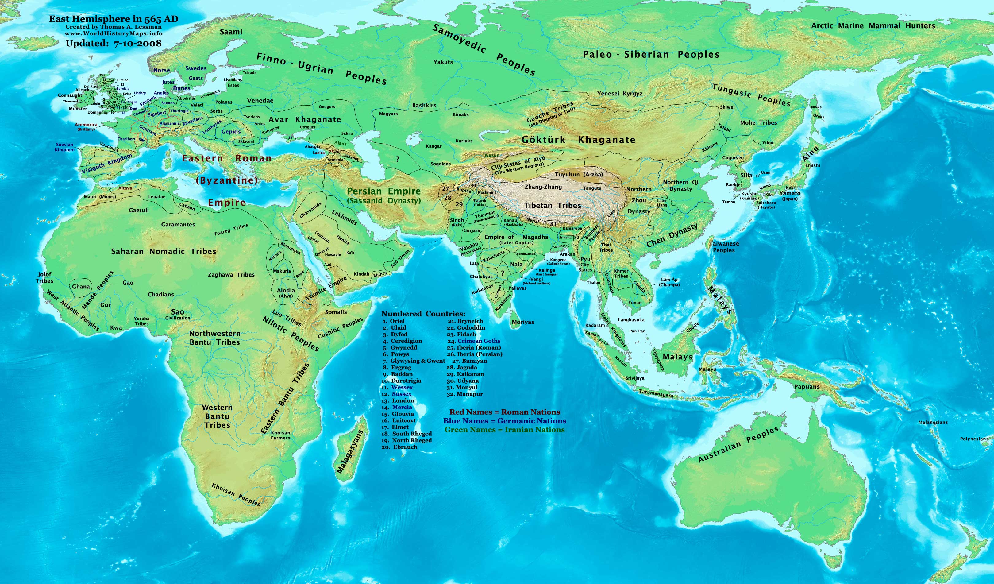
English: Eastern Hemisphere in 565 AD |
| Źródło | self-made (For reference information, see the Map Source References section below.) |
| Autor | Thomas Lessman (Contact!) |
| Licencja (Ponowne użycie tego pliku) |
Ja, właściciel praw autorskich do tego dzieła, udostępniam je na poniższej licencji Ten plik udostępniony jest na licencji Creative Commons Uznanie autorstwa – Na tych samych warunkach 3.0.
|
| Inne wersje |
Prace pochodne od tego pliku: see East-Hem_565ad.jpg file history on Wikipedia. |
Map Summary
Original Source URL: http://www.thomaslessman.com/History/images/East-Hem_565ad.jpg.
This map of the Eastern Hemisphere in 565 AD was created by Thomas Lessman, based on information from the sources listed below. This map is free for educational use (see Permission info above). When using this map, please mention that it is available for free at www.WorldHistoryMaps.info.
Map Source References
- Remember, sources often conflict with each other. This map is only as accurate as the information that is available to me. To report any errors or to help further this work, please click here, or email Thomas Lessman at talessman@yis.us
References for information contained in this map:
Primary Sources for East-Hem_565ad.jpg:
- 1. The DK Atlas of World History, 2000 Edition; map of The World in 500 CE, (Pages 50-51) (See other specific references below)
- 2. John Nelson. Map of the "Countries of the World 1/1/565 CE." Interactive Historical Atlas of the World since 500BCE. World History Maps Inc., Alexandria, VA, 2008. Available at www.WorldHistoryMaps.com.
- 3. The History & Commercial Atlas of China, maps of The Divisions of China, 530 & 560 AD and Asia in 610 AD, available at Huhai.net
- 4. Wikimedia's World Map 500 CE, made by User:Javierfv1212, and Wikipedia articles (noted below).
I - African Information
Note: Most of my African Information comes from The DK Atlas of World History map of The Development of Complex Societies in Africa; (Pg 160).
- (Bantus, Berber Tribes, Chadians, Cushites, Daamat, Garamantes, Gur, Khoisan Peoples, Kwa, Libyans, Mandes, Nilotic Peoples, West Atlantic Peoples)
- Nubian/Sudanese borders (Makuria, Nobatia, Alodia, Blemmyes, Bega, Axum, etc.) are derived from these sources:
- 1. The DK Atlas of World History map of "Northeast Africa, c. 500 CE"; (Pg. 161)
- 2. Denis Bellemare. Historical Atlas of Late Antiquity. Map of Arabia in 540 AD
- Ghana's location is derived from John Nelson's map of the "Countries of the World, 1-1-500 CE", available at www.WorldHistoryMaps.com.
- North African borders are derived from a comparison of
- 1. Denis Bellemare. Historical Atlas of Late Antiquity. Comparison of the maps of North Africa in 540 AD and North Africa in 580 AD.
II - Asian Information
- Arabian borders & Tribal locations are derived from a combination of these sources:
- 1. The MidEastWeb.org map of Arabia in 500 CE.
- 2. Denis Bellemare. Historical Atlas of Late Antiquity. Maps of "Southern Arabia in 540 AD and North Arabia in 540 AD.
- 3. Wikipedia's map of Pre-Islamic Arab tribal locations, created by User:Slackerlawstudent.
Note: I used information in various Wikipedia articles to reconcile the maps and the borders I depict for Arabia.
- Chinese Borders are derived from the History & Commercial Atlas of China, map of The Divisions of China, 530 & 560 AD, available on Huhai.net
- India's borders are derived from these sources:
- 1. John Nelson. Map of the "Countries of the World 1/1/565 CE." Interactive Historical Atlas of the World since 500BCE. World History Maps Inc., Alexandria, VA, 2008. Available at www.WorldHistoryMaps.com.
- 2. The Historical Atlas of South Asia, maps of "The Gupta-Vakataka Age, c. A.D. 300-500" and "The age of Pusyabhuti and Calukyan ascendancy, c. A.D. 550-700", by Joseph Schwartzberg.
- Japanese information is derived from The DK Atlas of World History map of "State Formation in Korea & Japan to 650 CE"; (Pg 264)
III - European Information
Note: Borders of Europe are mostly derived from a combination of:
1. The www.Euratlas.com map of Europe in 600 AD and to a lesser extent, their map of Europe in 500 AD.
- (Please note: User:Bogomolov.PL has done a great job of showing me possible discrepancies in my north European borders compared to this source, due to the differences in the geographical layout of the maps.)
2. John Nelson. Map of the "Countries of the World 1/1/565 CE." Interactive Historical Atlas of the World since 500BCE. World History Maps Inc., Alexandria, VA, 2008. Available at www.WorldHistoryMaps.com.
- British/English Borders derived from "Early British Kingdoms" map of Britain in 550 AD and their map of Britain in 575 AD.
4. Fringe areas like Africa, Australia, Siberia, etc. are partially derived from Wikimedia's map of The world in 500 CE, created by User:Javierfv1212.
5. Much of the information in this map was cross-checked with Bruce Gordon's Regnal Chronologies.
Other Maps by Thomas Lessman
| Maps of the eastern hemisphere showing history
Bold dates are available on Wikimedia or Wikipedia. | ||
| Primeval | ||
| Ancient
|
·| 600 BC | 550 BC | 527 BC | 500 BC |
400 BC | ·| 1 AD | 50 AD | 100 AD | 200 AD | 300 AD | | |
| Medieval |
·| 500 AD | 565 AD | 600 AD | 700 AD | | |
| Modern |
·| 1500 AD | · * For historical maps of the whole world, | |
| history links talk edit view | ||
Podpisy
Obiekty przedstawione na tym zdjęciu
przedstawia
Jakaś wartość bez elementu Wikidanych
Historia pliku
Kliknij na datę/czas, aby zobaczyć, jak plik wyglądał w tym czasie.
| Data i czas | Miniatura | Wymiary | Użytkownik | Opis | |
|---|---|---|---|---|---|
| aktualny | 00:29, 11 lip 2008 | | 3240 × 1903 (773 KB) | Talessman | |
| 23:18, 9 maj 2008 |  | 3240 × 1903 (760 KB) | Talessman | {{Information |Description=Eastern Hemisphere in 565 AD. |Source=self-made |Author=Thomas Lessman |Permission={{self|cc-by-sa-3.0}} }} |
Lokalne wykorzystanie pliku
Żadna strona nie korzysta z tego pliku.
Globalne wykorzystanie pliku
Ten plik jest wykorzystywany także w innych projektach wiki:
- Wykorzystanie na azb.wikipedia.org
- Wykorzystanie na bar.wikipedia.org
- Wykorzystanie na be.wikipedia.org
- Wykorzystanie na br.wikipedia.org
- Wykorzystanie na de.wikipedia.org
- Wykorzystanie na el.wikipedia.org
- Wykorzystanie na en.wikipedia.org
- Wykorzystanie na es.wikipedia.org
- Wykorzystanie na fa.wikipedia.org
- Wykorzystanie na fr.wikipedia.org
- Wykorzystanie na hr.wikipedia.org
- Wykorzystanie na hy.wikipedia.org
- Wykorzystanie na ka.wikipedia.org
- Wykorzystanie na mn.wikipedia.org
- Wykorzystanie na no.wikipedia.org
- Wykorzystanie na pt.wikipedia.org
- Wykorzystanie na rue.wikipedia.org
- Wykorzystanie na ru.wikipedia.org
- Wykorzystanie na sh.wikipedia.org
- Wykorzystanie na sl.wikipedia.org
- Wykorzystanie na sv.wikipedia.org
- Wykorzystanie na tr.wikipedia.org
- Wykorzystanie na uk.wikipedia.org
- Wykorzystanie na vi.wikipedia.org
Metadane
Niniejszy plik zawiera dodatkowe informacje, prawdopodobnie dodane przez aparat cyfrowy lub skaner użyte do wygenerowania tego pliku.
Jeśli plik był modyfikowany, dane mogą być częściowo niezgodne z parametrami zmodyfikowanego pliku.
| _error | 0 |
|---|