File:Deutschland_topo.jpg
From Wikipedia, the free encyclopedia
Size of this preview: 454 × 599 pixels. Other resolutions: 182 × 240 pixels | 364 × 480 pixels | 582 × 768 pixels | 776 × 1,024 pixels | 2,011 × 2,654 pixels.
Original file (2,011 × 2,654 pixels, file size: 1.76 MB, MIME type: image/jpeg)
| This is a file from the Wikimedia Commons. Information from its description page there is shown below. Commons is a freely licensed media file repository. You can help. |
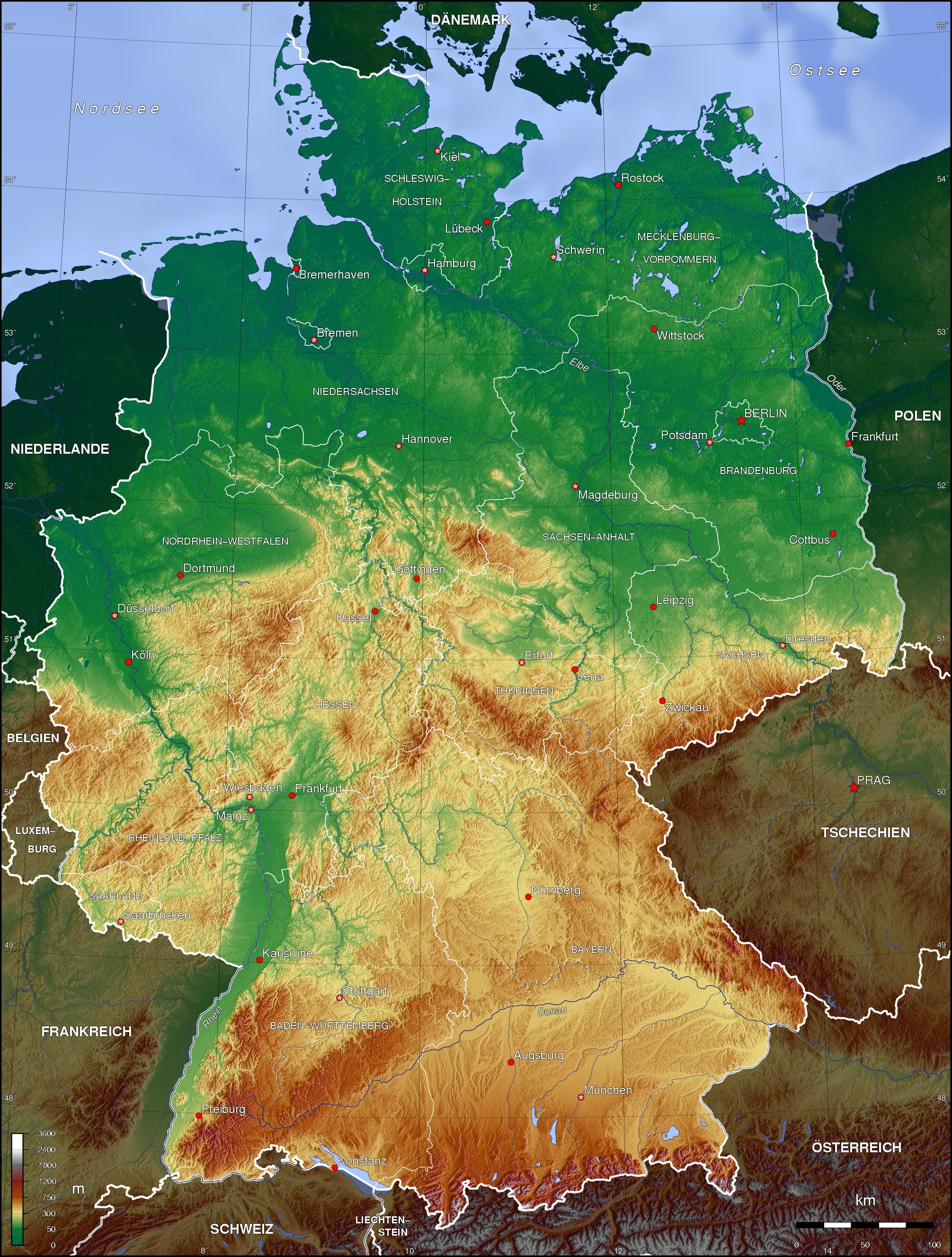
| DescriptionDeutschland topo.jpg |
English: Topographic map of Germany (Borders of the States of Germany approximately as of 1990) Deutsch: Topografische Karte Deutschlands (Verlauf der Ländergrenzen etwa Stand 1990) |
| Date | |
| Source | Own work |
| Author | Botaurus-stellaris |
The map has been created with the Generic Mapping Tools: https://www.generic-mapping-tools.org/ using one or more of these public-domain datasets for the relief:
বাংলা ∙ English ∙ español ∙ français ∙ italiano ∙ 日本語 ∙ македонски ∙ sicilianu ∙ 中文(简体) ∙ 中文(繁體) ∙ +/− |

|
Permission is granted to copy, distribute and/or modify this document under the terms of the GNU Free Documentation License, Version 1.2 or any later version published by the Free Software Foundation; with no Invariant Sections, no Front-Cover Texts, and no Back-Cover Texts. A copy of the license is included in the section entitled GNU Free Documentation License.http://www.gnu.org/copyleft/fdl.htmlGFDLGNU Free Documentation Licensetruetrue |
| This file is licensed under the Creative Commons Attribution-Share Alike 3.0 Unported license. | ||
| ||
| This licensing tag was added to this file as part of the GFDL licensing update.http://creativecommons.org/licenses/by-sa/3.0/CC BY-SA 3.0Creative Commons Attribution-Share Alike 3.0truetrue |
derivative works
Derivative works of this file: Deutschland topo cropped.jpg
Captions
Add a one-line explanation of what this file represents
Germany topo
Топографическая карта Германии
Items portrayed in this file
depicts
some value
17 November 2006
image/jpeg
File history
Click on a date/time to view the file as it appeared at that time.
| Date/Time | Thumbnail | Dimensions | User | Comment | |
|---|---|---|---|---|---|
| current | 23:43, 16 November 2006 | | 2,011 × 2,654 (1.76 MB) | Botaurus-stellaris |
File usage
The following pages on the English Wikipedia use this file (pages on other projects are not listed):
Global file usage
The following other wikis use this file:
- Usage on af.wikipedia.org
- Usage on als.wikipedia.org
- Usage on ar.wikipedia.org
- Usage on ast.wikipedia.org
- Usage on azb.wikipedia.org
- Usage on az.wikipedia.org
- Usage on bar.wikipedia.org
- Usage on be-tarask.wikipedia.org
- Usage on be.wikipedia.org
- Usage on bn.wikipedia.org
- Usage on bo.wikipedia.org
- Usage on bs.wikipedia.org
- Usage on bxr.wikipedia.org
- Usage on ce.wikipedia.org
- Usage on ckb.wikipedia.org
- Usage on cs.wikipedia.org
- Usage on da.wikipedia.org
- Usage on de.wikipedia.org
- Karte (Kartografie)
- Benutzer:Nainoa
- Benutzer:Meisel
- Benutzer:Kiezkicker
- Bucht
- Wikipedia:WikiProjekt Kommunen und Landkreise in Deutschland
- Benutzer:Meph666/Galerie
- Benutzer:Metrics
- Benutzer:Kuellmann.de
- Benutzer:Paulimausi
- Benutzer:RMeier
- Wikipedia:Kandidaten für exzellente Bilder/Archiv2005/10
- Benutzer:Dr Nibbles
- Benutzer:Tjö
- Geographie Deutschlands
- Benutzer:Neurowiki
- Benutzer:MyChaOS
- Benutzer:Behrev
- Benutzer:Stefan Zwierlein
View more global usage of this file.
Metadata
This file contains additional information, probably added from the digital camera or scanner used to create or digitize it.
If the file has been modified from its original state, some details may not fully reflect the modified file.
| _error | 0 |
|---|
Retrieved from "https://en.wikipedia.org/wiki/File:Deutschland_topo.jpg"