File:Sudeten_m.svg
From Wikipedia, the free encyclopedia

Size of this PNG preview of this SVG file: 800 × 503 pixels. Other resolutions: 320 × 201 pixels | 640 × 402 pixels | 1,024 × 644 pixels | 1,280 × 805 pixels | 2,560 × 1,610 pixels | 1,576 × 991 pixels.
Original file (SVG file, nominally 1,576 × 991 pixels, file size: 195 KB)
| This is a file from the Wikimedia Commons. Information from its description page there is shown below. Commons is a freely licensed media file repository. You can help. |
Summary
| DescriptionDivisions of the Sudetes.svg |
English: Divisions of the Sudetes Deutsch: Naturräumliche Gliederung der Sudeten Polski: Sudety Čeština: Krkonošsko-jesenická subprovincie (This article is just about the Czech Part of the Sudetes) |
| Date | |
| Source |
Own work This file was derived from: Sudeten.png |
| Author | Pavouk (colors and revised legend: W like wiki) |
| Other versions |
|

Legend
Original legend copied from de:Sudeten#Gliederung (copy date was 2009)
Notes:
- ↑ a b c d The Czech names for Nr. 21 (Góry Kamienne), 22 (Lubavská brána), 25 (Broumovská kotlina) and 26 (Stolové hory) are names for landscapes. The Czech parts of these landscapes are geomorphologicaly put together under different names in one region called cs:Broumovská vrchovina IVB-1 (pl:Broumovská vrchovina, de:Braunauer Bergland).
- Region is part of these countries
- The numbers behind the polish names in the table are polish region numbers. (The underlining of some numbers meaning nothing but to separate them visually: 332.2 and its subdevisions from 332.3 in Western Sudetes and 332.1 and its subdevisions from 332.4 and 332.5 in Central Sudetes.)
For a map of the polish part of the sudetes with region numbers see: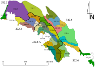 Sudety podzial.svg or with elevations
  Polish Regiony Southwest with Sudetes.png
 - for more details see also:
- pl:Sudety#Podział Sudetów (łącznie z przedgórzem) – Division of the Sudetes (including the foothills)
- cs:Krkonošsko-jesenická subprovincie – Czech name of the area


Licensing
I, the copyright holder of this work, hereby publish it under the following license:
This file is licensed under the Creative Commons Attribution-Share Alike 3.0 Unported license.
- You are free:
- to share – to copy, distribute and transmit the work
- to remix – to adapt the work
- Under the following conditions:
- attribution – You must give appropriate credit, provide a link to the license, and indicate if changes were made. You may do so in any reasonable manner, but not in any way that suggests the licensor endorses you or your use.
- share alike – If you remix, transform, or build upon the material, you must distribute your contributions under the same or compatible license as the original.
Captions
Add a one-line explanation of what this file represents
Karte des Sudeten mit deren Unterteilung in drei Zonen und 42 Naturräume
Items portrayed in this file
depicts
15 September 2013
image/svg+xml
File history
Click on a date/time to view the file as it appeared at that time.
| Date/Time | Thumbnail | Dimensions | User | Comment | |
|---|---|---|---|---|---|
| current | 00:24, 8 January 2021 | | 1,576 × 991 (195 KB) | W like wiki | 33a switched with 33b |
| 00:19, 8 January 2021 |  | 1,576 × 991 (195 KB) | W like wiki | #33: Góry Bystrzyckie and Góry Orlickie "a bit" separated, in #4: border of Kotlina Żytawska | |
| 03:28, 24 December 2020 |  | 1,576 × 991 (193 KB) | W like wiki | blue borders, blue states | |
| 03:21, 24 December 2020 |  | 1,576 × 991 (193 KB) | W like wiki | corr mistake at #22 | |
| 03:02, 24 December 2020 |  | 1,576 × 991 (193 KB) | W like wiki | subregions in separate colors to show better the connections across the fat blue state borders | |
| 16:38, 15 September 2013 |  | 1,576 × 991 (156 KB) | Pavouk | User created page with UploadWizard |
File usage
The following pages on the English Wikipedia use this file (pages on other projects are not listed):
Global file usage
The following other wikis use this file:
- Usage on bs.wikipedia.org
- Usage on cs.wikipedia.org
- Usage on da.wikipedia.org
- Usage on de.wikipedia.org
- Usage on de.wikibooks.org
- Usage on de.wikiversity.org
- Usage on de.wikivoyage.org
- Usage on de.wiktionary.org
- Usage on el.wikipedia.org
- Usage on en.wikivoyage.org
- Usage on en.wiktionary.org
- Usage on eo.wikipedia.org
- Usage on es.wikipedia.org
- Usage on fa.wikipedia.org
- Usage on fi.wikipedia.org
- Usage on fr.wikipedia.org
- Usage on fy.wikipedia.org
- Usage on hsb.wikipedia.org
- Usage on incubator.wikimedia.org
- Usage on is.wikipedia.org
- Usage on it.wikipedia.org
- Usage on ko.wikipedia.org
- Usage on mk.wikipedia.org
- Usage on no.wikipedia.org
- Usage on pl.wikipedia.org
- Usage on sco.wikipedia.org
- Usage on sh.wikipedia.org
- Usage on sk.wikipedia.org
View more global usage of this file.
Metadata
This file contains additional information, probably added from the digital camera or scanner used to create or digitize it.
If the file has been modified from its original state, some details may not fully reflect the modified file.
| Width | 1261pt |
|---|---|
| Height | 793pt |
Retrieved from "https://en.wikipedia.org/wiki/File:Divisions_of_the_Sudetes.svg"