Fichier:Arctic_sea_ice_loss_animation.gif
De Wikipedia, l'encyclopédie encyclopedia
Arctic_sea_ice_loss_animation.gif (361 × 252 pixels, taille du fichier : 850 kio, type MIME : image/gif, en boucle, 32 trames, 21 s)
Ce fichier et sa description proviennent de Wikimedia Commons.
Description
| DescriptionArctic sea ice loss animation.gif |
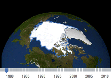
English: Declining Arctic sea ice: 1979-2010
Changes in Arctic sea ice are an indicator of climate change. Observations from NASA satellites show that Arctic sea ice is now declining at a rate of 11.5 percent per decade, relative to the 1979 to 2000 average. Arctic sea ice reaches its minimum extent each September. This time series, based on satellite data, shows the annual Arctic sea ice minimum since 1979. The September 2010 extent was the third lowest in the satellite record. Among the NASA missions that help monitor Earth’s ice are the Gravity Recovery and Climate Experiment (GRACE), Terra and IceSat. Bear in mind there was a chain of undersea volcanos that erupted almost all year in 2007 beneath the ice cap. This is almost never mentioned but it is fairly critical to late in the ice loss in 2007. This time series was created by scientists who study this; they say by 2045, Earth's temperature may increase to effect the melting of ice. |
| Date | |
| Source | http://photojournal.jpl.nasa.gov/catalog/PIA14385 |
| Auteur | NASA/Goddard Scientific Visualization Studio and adapted for NASA’s Global Climate Change website http://climate.nasa.gov/ |
| Autorisation (Réutilisation de ce fichier) |
Studio Scientific |
Conditions d’utilisation
| Public domainPublic domainfalsefalse |
| Ce fichier provient de la NASA. Sauf exception, les documents créés par la NASA ne sont pas soumis à copyright. Pour plus d'informations, voir la politique de copyright de la NASA. | ||
 |
Attention :
|
| Annotations InfoField | Cette image est annotée : Voir les annotations sur Wikimedia Commons |
Alaska
Grönland
Spitzbergen
Canada
Nordpol
Légendes
Éléments décrits dans ce fichier
dépeint
image/gif
8918eba5648bea43876f0fa8bdf108c49db8df7b
870 857 octet
20,5 seconde
252 pixel
361 pixel
Historique du fichier
Cliquer sur une date et heure pour voir le fichier tel qu'il était à ce moment-là.
| Date et heure | Vignette | Dimensions | Utilisateur | Commentaire | |
|---|---|---|---|---|---|
| actuel | 31 juillet 2011 à 06:18 | | 361 × 252 (850 kio) | Maddox2 | {{Information |Description ={{en|1=Declining Arctic sea ice: 1979-2010 Changes in Arctic sea ice are an indicator of climate change. Observations from NASA satellites show that Arctic sea ice is now declining at a rate of 11.5 percent per decade, re |
| 31 juillet 2011 à 06:17 |  | 361 × 252 (850 kio) | Maddox2 | {{Information |Description ={{en|1=Declining Arctic sea ice: 1979-2010 Changes in Arctic sea ice are an indicator of climate change. Observations from NASA satellites show that Arctic sea ice is now declining at a rate of 11.5 percent per decade, re |
Utilisation du fichier
La page suivante utilise ce fichier :
Usage global du fichier
Les autres wikis suivants utilisent ce fichier :
- Utilisation sur cs.wikipedia.org
- Utilisation sur de.wikipedia.org
- Utilisation sur en.wikipedia.org
- Utilisation sur fi.wikibooks.org
- Utilisation sur incubator.wikimedia.org
- Utilisation sur ka.wikipedia.org
- Utilisation sur ne.wikipedia.org
- Utilisation sur nn.wikipedia.org
- Utilisation sur pt.wikipedia.org
- Utilisation sur ta.wikipedia.org
- Utilisation sur uk.wikipedia.org
- Utilisation sur vi.wikipedia.org